
Strongest El Nino on Record Developing Now
08/02/2026, 1:59 pm EDT
Climate Impact Company 2026 North Atlantic Basin
FINAL Tropical Cyclone Outlook
Issued: Monday August 3, 2026
Highlight: The 2026 seasonal forecast is cut lower – again due to developing super El Nino.
Executive summary: Climate Impact Company has revised the 2026 North Atlantic basin tropical cyclone season activity forecast LOWER to 9 tropical storms, 3 hurricanes, and 2 major hurricanes. The ACE index forecast is 50. The CIC forecast is similar with the Colorado State University downward revision. ECMWF rainfall probability forecasts indicate this year’s activity is heavily biased toward the subtropics with very limited deep tropics development. The outlook is revised lower due to the evolving super El Nino and the suppressing effects of El Nino on tropical cyclone development.
| Tropical Storms | Hurricanes | Intense Hurricanes | ACE Index | |
| New Forecast | 9 | 3 | 2 | 50 |
| 5/28/26 | 11 | 5 | 3 | 73 |
| 3/28/26 | 13 | 5 | 3 | 98 |
| CSU | 9 | 4 | 1 | 50 |
| NOAA | 8-14 | 3-6 | 1-3 | 45-115% |
| 30-Yr NML | 14.4 | 7.2 | 3.2 | 123 |
Table 1: The Climate Impact Company updated North Atlantic basin seasonal tropical cyclone forecast for 2026 compared to CSU, NOAA, and normal.
Climate discussion: Super El Nino is developing across the eastern equatorial Pacific Ocean (Fig. 1). Daily Nino34 SSTA observations reveal +2.50 while July 2026 southern oscillation index (SOI) was -2.68, both within super El Nino thresholds. In the tropical North Atlantic, marginally warm SSTA have developed although the equatorial region is cooler than normal. Marine heatwaves (MHW) stretch across the southeastern North Pacific basin and subtropical North Atlantic. The SSTA pattern suggests buoyant tropical cyclone activity ahead in the East Pacific with above normal risk of systems turning northward toward California, Baja California, and Mexico to the Southwest U.S. An exceptionally wet Southwest U.S. Monsoon should develop given the SSTA regime in the East Pacific. In the North Atlantic, the best location for development and tracks are across the warmer subtropical waters while El Nino westerly shear defeats deep tropics development. The upper ocean heat in the North Atlantic deep tropics is near normal for the 2013-25 period of record and somewhat cooler than recent years (Fig. 2).
The ECMWF AUG/SEP/OCT 2026 global SSTA forecast maintains super El Nino development and warms both the southeastern North Pacific basin and the subtropical/tropical North Atlantic basin (Fig. 3). Upper air patterns related to the El Nino climate will promote above to well above normal tropical cyclone activity in the East Pacific. However, the El Nino shear will prevent tropical cyclone activity in the North Atlantic deep tropics despite the warming ocean surface. In the North Atlantic, the best location for tropical cyclone activity during the 2026 season is in the subtropics.
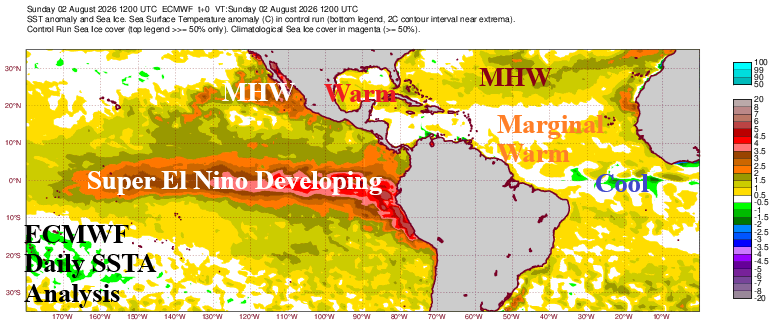
Fig. 1: ECMWF daily SSTA analysis of the tropical/subtropical East Pacific and North Atlantic.
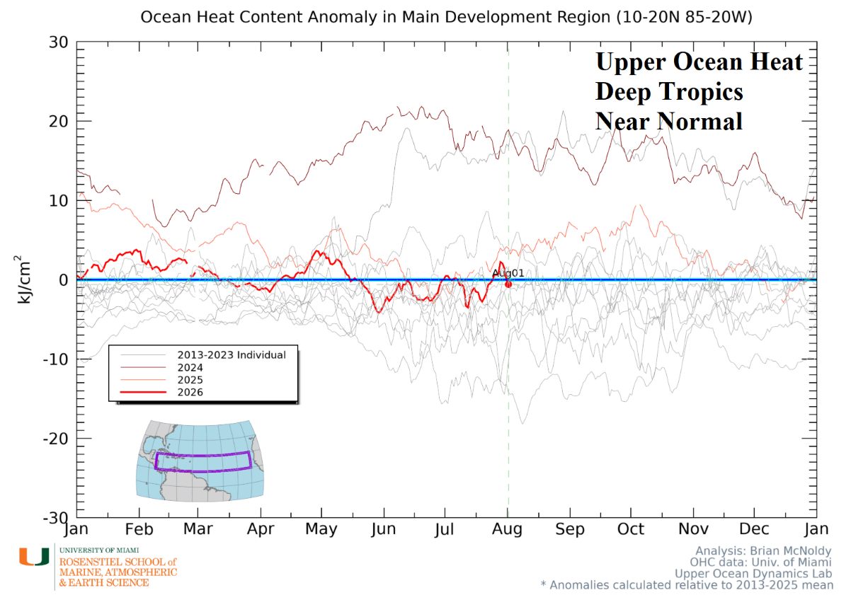
Fig. 2: Upper ocean heat content of the North Atlantic tropics.
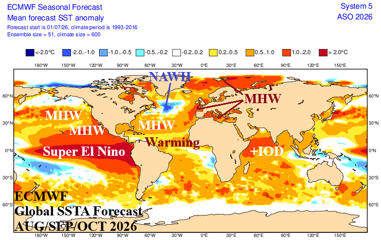
Fig. 3: ECMWF global SSTA forecast for AUG/SEP/OCT 2026.
Activity forecast discussion: Given the strength of El Nino, analog years are confined to strongest El Nino years on record: 1982, 1997, and 2015. Given the warming of mid-latitude oceans during the past 1-2 decades, the 2015 analog year is counted twice. The analog forecast is revised lower from previous outlooks to 9 tropical storms, 3 hurricanes, and 2 intense hurricanes (Table 2).
| Year | Weight | Tropical Storms | Hurricanes | Major Hurricanes | ACE Index |
| 2015 | 2 | 11 | 4 | 2 | 63 |
| 1997 | 1 | 8 | 3 | 1 | 41 |
| 1982 | 1 | 6 | 2 | 1 | 32 |
| Average | 9.0 | 3.3 | 1.5 | 49.8 | |
| Forecast | 9 | 3 | 2 | 50 | |
| Previous | 11 | 5 | 2 | 73 | |
| Normal | 14.4 | 7.2 | 3.2 | 123 |
Table 2: The analog years and their weighting used to generate the Climate Impact Company 2026 North Atlantic basin seasonal tropical cyclone season forecast.
U.S. impacts discussion: Utilizing ECMWF seasonal rainfall probability forecasts for AUG/SEP/OCT and SEP/OCT/NOV 2026, the risk of where tropical cyclone activity is likely to have impacts is clearly in the subtropics and not the deep tropics (Fig. 4-5). The AUG/SEP/OCT 2026 (ECMWF) outlook indicates strong support for dangerous tropical cyclone tracks into Baja California with attendant rainfall spreading across the Southwest U.S. Risk of major flooding across this stretch is favored. Tropical systems will track westward and reach Hawaii. In the western North Atlantic, the rainfall probability forecast by ECMWF is arid and potentially represents a total lack of deep tropics tropical cyclones. The favored areas for tropical cyclone impacts are in Louisiana likely caused by local development. During SEP/OCT/NOV 2026 ECWMF indicates the Northern Gulf of Mexico and North Atlantic subtropics are quite wet likely associated with tropical systems that form in these areas and track into the Northern Gulf of America Coast and possibly the Mid-Atlantic Coast most likely during September and possibly early October.
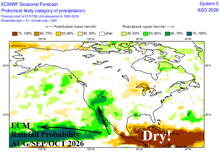
Fig. 4: ECMWF global SSTA forecast for AUG/SEP/OCT 2026 with potential tropical cyclone tracks.
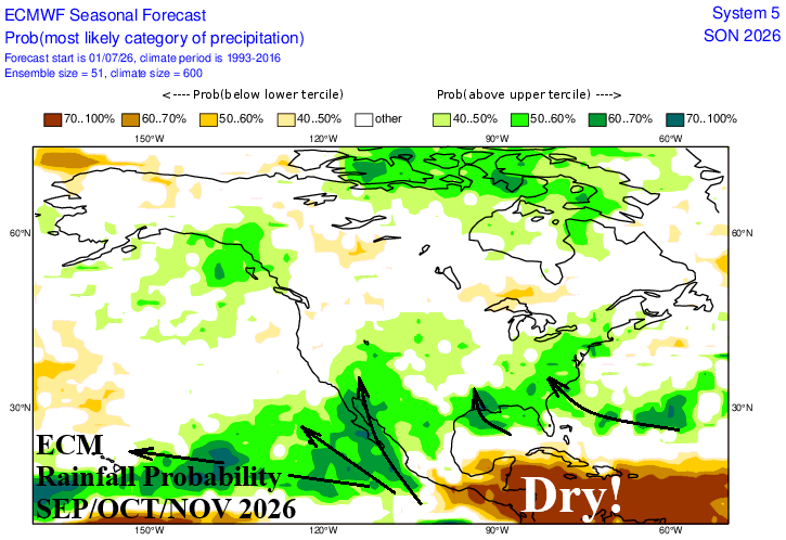
Fig. 5: ECMWF global SSTA forecast for SEP/OCT/NOV 2026 with potential tropical cyclone tracks.