First Northern Hemisphere Summertime El Nino Since 2015 in 2026? Maybe!
02/11/2026, 5:01 am EST
Oceanic La Nina Ends, Subsurface Warming Validates El Nino Forecasts for Mid-year. But! Atmosphere Not Responding Yet.
02/16/2026, 11:52 am EST
Climate Impact Company Early U.S. Notes
Issued: Friday February 13, 2026
Highlight: Support to keep U.S. pattern warm increasing. News on new Nino34 SSTA index and AIFS updates.
News ONE: Yesterday, NOAA announced a new ENSO index. The new index is named the Relative Operational Nino Index (RONI). The old index, Operational Nino Index (ONI) was a 3-month running average of the Nino34 monthly sea surface temperature anomaly (SSTA) compared to the 30-year normal (of Nino34). The new index compares the Nino34 region to the global tropics (20N to 20S) over 5 over-lapping 3-month periods. The goal of this approach is to provide a more accurate measurement of the Nino34 SSTA relative to the warming of the oceans over many decades. Historically, this new method makes previous La Nina’s a little stronger and previous El Nino’s a little weaker. In some cases, weak El Nino is erased. The NOAA explanation is below.
The Climate Impact Company response is problematic. First, commodities markets watching ENSO indices, particularly global agriculture, are interested in pattern change and intensity of ENSO events. Second, the 5-month average lowers the ability to identify a change or peak intensity although a better job at identifying Nino34 observations as they relate to long-term (ocean) climate. Third, the base climatology is compared to 20N to 20S global tropics while the Nino SSTA regions are traditionally within 5 degrees of the equator.
Climate Impact Company will produce a second database with RONI data and (new) constructed analog forecast, issued next week. However, an added service that recognizes DAILY observations and their 7-day, 14-day, and 30-day SSTA changes (data provided by CWG/SVWM) to keep pace with commodities interest in this important climate diagnostic begins shortly.
News TWO: CWG/SVWM announced (yesterday) that model updates to ECMWF and AIFS are ahead. Primary change, AIFS adds snowfall and 10 MB temperature anomalies (stratosphere).
Today’s weather discussion: Speaking of ENSO, evolving important (ENSO) diagnostics are likely to affect the U.S. weather pattern sooner rather than later. The latest 2-week Madden Julian oscillation (MJO) forecast (Fig. 1) indicates a split decision on a moderate-to-strong MJO event in phase_3 weakening during the 8-14/11-15-day period (ECM) or strengthening and shifting east through phase_4 and phase_5 (GFS). The eastward shift through phase_4 and phase_5 is a strong warming signal for the U.S. and if correct would likely defeat cold Northeast/East U.S. implications by ongoing negative West Pacific oscillation (-WPO) forecasts for that time frame. What makes the eastward progression particularly interesting is the passage over extremely warm anomalous ocean water just beneath the surface across the length of the Pacific near the equator (Fig. 2). A double Kelvin Wave has warmed the subsurface and upper ocean heat is accelerating (Fig. 3). HDD forecasts have shifted a little warmer for late FEB/early MAR (Fig. 4) and the warmer week 4-5 AI models are preferred for the extended range (Fig. 5).
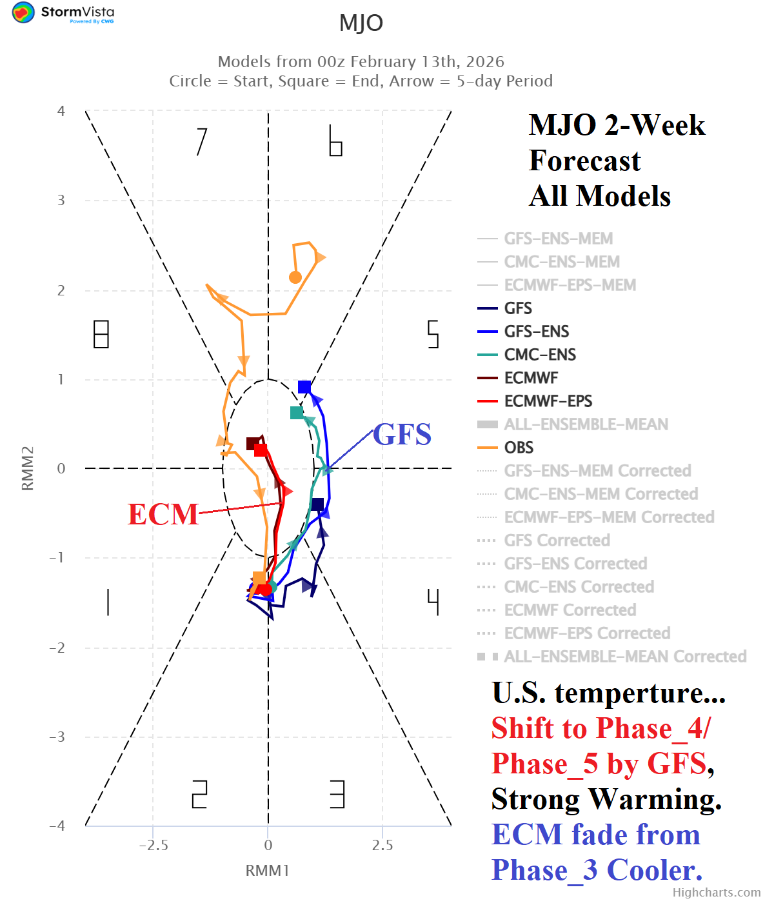
Fig. 1: MJO 2-week forecast indicates a split decision between weakening (ECM) or eastward progression (GFS). Eastward progression is a strong warm signal for the U.S.
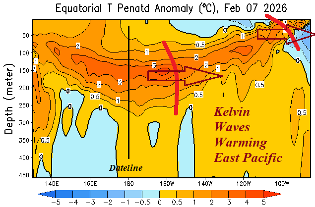
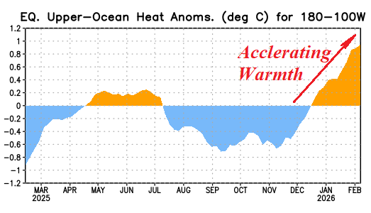
Fig. 2-3: The subsurface equatorial Pacific is warming dramatically, accelerating during recent weeks.
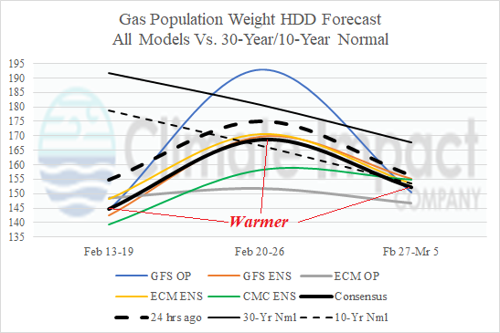
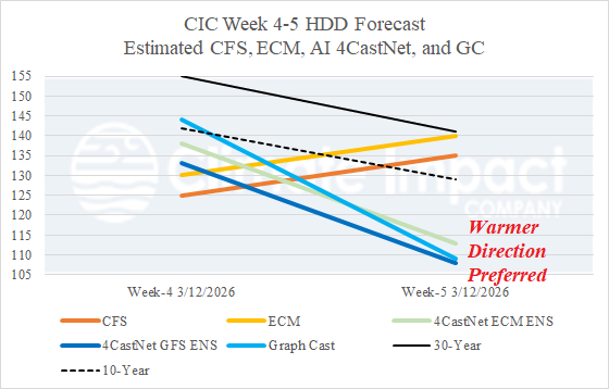
Fig. 4-5: The U.S. gas population weight HDD forecast utilizing all models shifts slightly warmer into early March while the warmer forecasts for week 4-5 ahead are preferred.