Pattern Change in The East U.S. Days 11-15?
09/28/2023, 5:35 am EDTUpper Ocean Heat Easing Slightly, Suggests El Nino 2023-24 Not a Super El Nino
10/02/2023, 2:07 pm EDT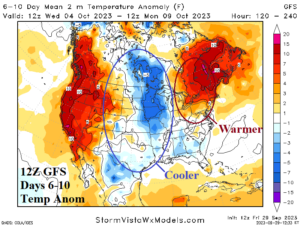
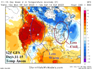
Fig. 1-2: 12Z GFS medium range temperature anomaly forecast.
Discussion: The midday 12Z GFS is cooler in the Central U.S. while the Northeast is somewhat warmer in the 6-10-day period (Fig. 1). The West Coast is quite warm. In the 11-15-day period, the previously indicated very warm outlook is less warm throughout the West-central States (Fig. 2). The Northeast cool forecast from yesterday is moderated to near normal. The 12Z GFS is much wetter in the Gulf region and throughout much of the East U.S. (Fig. 3-4). In the tropics, Tropical Storms Philippe and Rina turn northward and may each stall in the central North Atlantic later next week (Fig. 5).
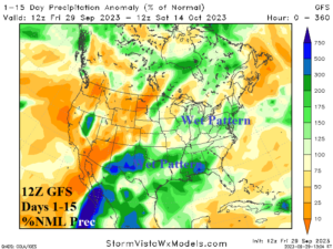
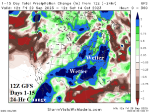
Fig. 3-4: The 12Z GFS percent of normal rainfall forecast and 24-hour change.
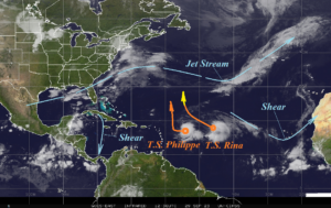
Fig. 5: North Atlantic basin satellite view and primary tropical features.
| Dates | HDD Forecast | 12-Hr Change | 24-Hr Change | 30-Year NML | 10-Year NML |
| Sep. 29- Oct. 5
| 12.8 | -0.6 | +1.5 | 35.0 | 28.4 |
| Oct. 6-12
| 44.2 | -3.4 | -5.0 | 47.9 | 39.3 |
| Oct. 13-19
| 44.1 | -10.9 | -7.0 | 62.5 | 52.5 |
Table 1: The 12Z GFS U.S. gas population weight HDD forecast compared to 12 and 24 hours ago.
| Dates | CDD Forecast | 12-Hr Change | 24-Hr Change | 30-Year NML | 10-Year NML |
| Sep. 29- Oct. 5
| 43.9 | +2.1 | +0.6 | 25.3 | 30.7 |
| Oct. 6-12
| 24.6 | -1.4 | -1.5 | 19.3 | 23.8 |
| Oct. 13-19
| 19.2 | +0.6 | +1.2 | 14.6 | 18.0 |
Table 2: The 12Z GFS U.S. population weight CDD forecast compared to 12 and 24 hours ago.