Midday 12Z GFS Trend is Much Wetter Eastern Half of U.S.
09/29/2023, 1:36 pm EDTTropics Present High Impact Weather This Weekend and Next Week
10/05/2023, 8:08 am EDT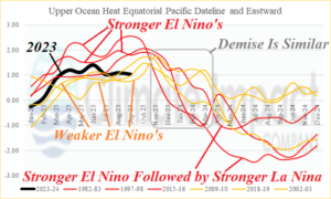
Fig. 1: The 12-week monitor of the Nino SSTA regions indicates a steady moderate to strong El Nino although very warm waters off the northwest coast of South America have cooled slightly.
Discussion: The upper ocean heat east of the Dateline along the equatorial Pacific appears to have peaked in June and eased slightly during the past 3 months (Fig. 1). Upper ocean heat is the fuel for El Nino. Comparing September 2023, the 9th month of an El Nino year, to the past 3 vigorous or moderate El Nino episodes indicates El Nino 2023 is moderately strong and trending toward the weaker El Nino’s regarding subsurface fuel supply and sustain the warm ENSO event. Note that early during year 2 of each El Nino episode, regardless of intensity, a steady uniform decline in upper ocean heat east of the Dateline is observed. Also note that to compensate for a strong El Nino, the subsurface equatorial Pacific to the east of the Dateline cooled dramatically by mid-to-late the following year. One diagnostic that is new during the past 30 days and supports the idea of a less intense El Nino is the cooling of the Northeast Pacific off the Coast. Implied is strengthening of an already strong cool phase of the Pacific decadal oscillation (-PDO) and a westward shift of Marine Heatwave NEP23A. In 2015, a MHW shifted to the West Coast and expanded enhancing El Nino and that scenario looks less likely for late 2023. Additionally, El Nino generally runs parallel to the PDO phase. The continuation of -PDO through late 2023 suggests El Nino 2023-24 is weaker and could collapse sooner by early next year. An El Nino winter is ahead in the northern hemisphere but less likely a super El Nino as witnessed in 1982-83, 1997-98, and 2015-16.
Last week, the Nino SSTA regions cooled slightly (Fig. 2). Peak warming in the Nino SSTA regions was earlier in September. Most notable was the decline in the Nino34 SSTA (by 0.2C).
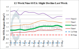
Fig. 2: The 12-week Nino SSTA observations indicate a slight decline from peak warmth earlier in September.