Upper Ocean Heat Easing Slightly, Suggests El Nino 2023-24 Not a Super El Nino
10/02/2023, 2:07 pm EDTOctober 2023 Global Soil Moisture Observations And Forecast
10/09/2023, 8:00 pm EDT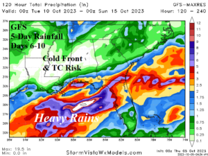
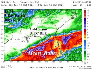
Fig. 1-2: GFS and ECM 5-day rainfall forecast across the Gulf of Mexico valid in the 6-10-day period.
Discussion: Next week a major rainfall event is indicated across the Gulf of Mexico and Florida (Fig. 1-2). A frontal system stalls over the northwest/north Gulf while to the south a tropical system emerges. The combination of the two events leads too heavy to extreme rain. Florida is implicated for the heavy rain mid-to-late next week. High wind caused by a possible tropical cyclone is an increasing concern.
Tropical Storm Philippe is north of Puerto Rico and heading northward. Forecast models take Philippe due north, just to the west of Bermuda later tomorrow, and farther north striking the upper Maine Coast Saturday night (Fig. 3). The remains of Philippe track westward and well inland into early next week. The passage of Philippe brings high wind gusts to eastern New England this weekend, particularly Maine (Fig. 4).
In the East Pacific, Tropical Storm Lidia meanders well southwest of Mexico the next 5 days but is likely to turn northeast and strike Mexico next week (Fig. 5). Some of the rainfall is likely entrained into the wet regime in the Gulf of Mexico next week.
Of interest across the North Atlantic basin is increasing upper shear likely indicating lowering risk of late season hurricane development (Fig. 6).
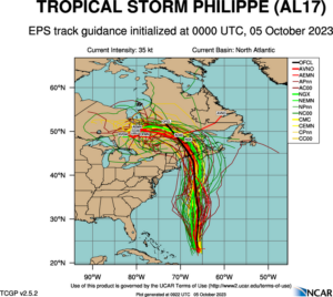
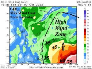
Fig. 3-4: Tropical cyclone models extended range forecast track for Tropical Storm Philippe and wind gust forecast valid at Noon Saturday for eastern New England.
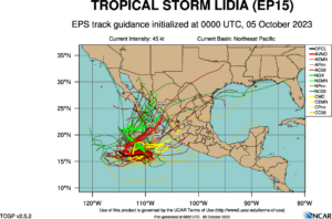
Fig. 5: Tropical cyclone models extended range forecast track for Tropical Storm Lidia implicating Mexico next week.
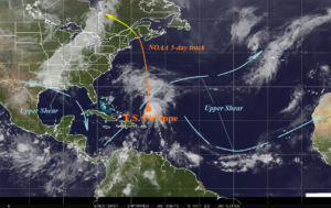
Fig. 6: North Atlantic basin satellite view and prominent tropical features.