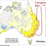
The Surprising Dry Climate in Australia
10/13/2025, 6:05 am EDT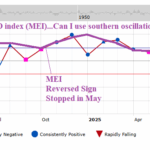
Can I Use Southern Oscillation Index to Approximate Multivariate ENSO Index?
10/20/2025, 7:28 pm EDT![]()
October 2025 Climate Impact Company Marine Heat Waves Outlook
Issued: Thursday October 16, 2025
Highlight: An explanation for the West/Central Pacific warming and changed character of the cool phase Pacific decadal oscillation.
Discussion: Since 2018, and especially in this decade, sea surface temperature anomalies (SSTA) have been consistently much warmer than normal and frequently record warm, off the East Asia Coast. Recent (Sep. 18) research published in Journal of Climate (“A New Dynamic Regime in the Kuroshio/Kuroshio Extension and the North Pacific Climate System after 2018” by Bo Qiu and Shuiming Chen) offers an explanation. Several factors including intensifying wind forcing over the southern subtropical gyre and weakened northern gyre (associated with the North Pacific subtropical high-pressure system), a widening Kuroshio Current (referred to as a large meander path) south of Japan, and the attendant altered storm tracks have contributed to the warming. The ocean warming is “manifested as frequent marine heatwaves (MHW) along the 35N to 45N band of the western North Pacific”.
Possibly related is the extension of the described new warm pattern eastward, past the Dateline, sometimes reaching the North America West Coast. NOAA’s California Current Integrated Ecosystem Assessment monitors the Northeast Pacific warming by identifying marine heatwaves, their progress, and forecasts. Marine heatwave NEP25A manifested as a “warm blob” in the Northeast Pacific peaking in early September (Fig. 1). However, as fast as the oceanic warming developed, cooling followed (Fig. 2).
Interestingly, the published research also offers a possible explanation for the change in character of cool phase Pacific decadal oscillation (-PDO). Since the change in the Kuroshio Current, and the attendant widespread ocean warming, the -PDO has reached steady record-breaking intensity (Fig. 3) despite the general warmer than normal observations in the Northeast Pacific (usually cooler than normal during -PDO). By comparison, the West/Central Pacific warming of the middle latitudes is extreme with much warmer anomalies than the Northeast Pacific, consequently a cool phase PDO.
Current global SSTA analysis (Fig. 4) reveals a plethora of MHW’s, most intense in the northern hemisphere (typical of early autumn). The most notable MHW’s are off the East Asia Coast, Central North Pacific, and off the Northwest Eurasia Coast. A new MHW has formed off the Southeast Canada Coast while MHW’s in the Caribbean Sea and off the Southwest Europe Coast are strengthening. At least 6 MHW’s are identified in the southern hemisphere. Typically, during the past decade, southern hemisphere MHW’s will intensify during summer/autumn.
In the last NOAA MHW assessment, analysis revealed global MHW coverage near 30% expected to weaken slightly in late 2025 and strengthen slightly in early 2026.
In the middle latitudes of both hemispheres, Climate Impact Company has observed increased strength of subtropical high pressure across or downwind large MHW regimes. The stronger subtropical ridge areas are causal to a warmer climate, when the ridge areas extend toward or across land mass. Additionally, the warming oceans provide increased low atmosphere moisture making synoptic scale storms and tropical cyclones potentially increasingly capable of producing extreme rainfall. MHW’s influence on climate rivals ENSO.
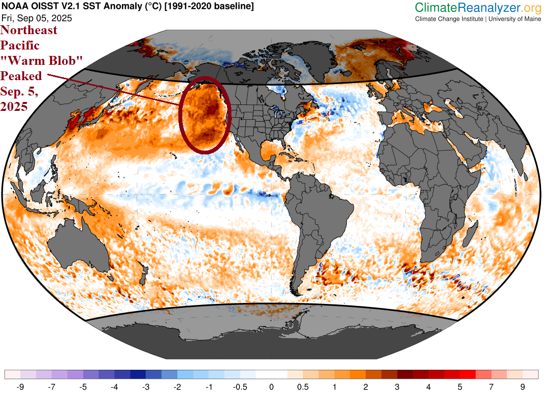
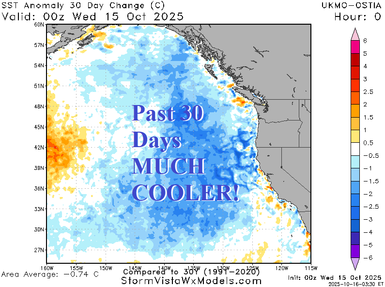
Fig. 1-2: The “warm blob” arrived in the Northeast Pacific during AUG/SEP followed by rapid dissipation in October.
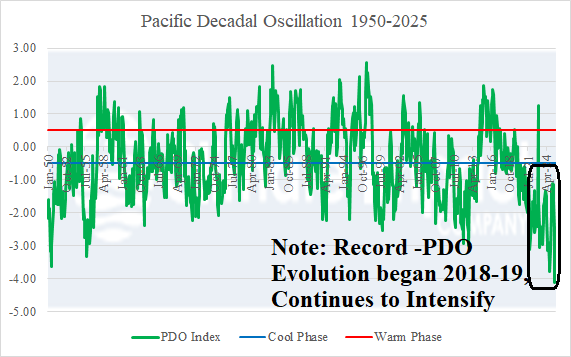
Fig. 3: The cool phase of the Pacific decadal oscillation continues to intensify due to the much warmer West/Central Pacific compared to the less warm Northeast Pacific.
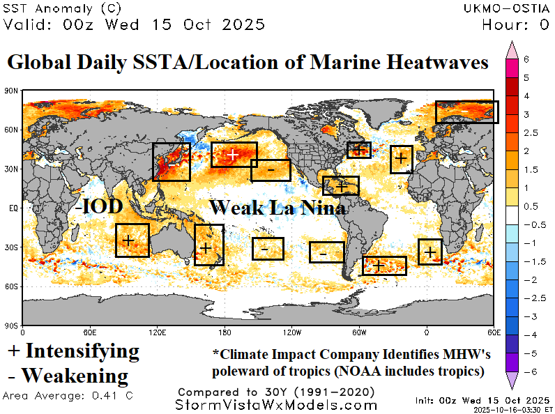
Fig. 4: Daily global SSTA analysis reveals where MHW’s are located.