North-central U.S. Blizzard Early Next Week Biases U.S. Medium-range Forecasts Cooler
03/22/2024, 8:35 am EDTEclipse Obscured by Cloudiness: Wind Event Central Great Plains Days 11-15
03/26/2024, 9:37 am EDT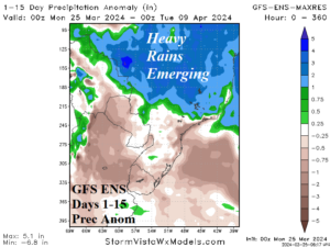
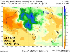
Fig. 1-2: The GFS ENS 15-day rainfall anomaly forecast across Argentina/Brazil and Australia.
Discussion: The Madden Julian oscillation (MJO) shifts through the longitude of the Americas and inspires steadily wetter weather across Brazil into early April (Fig. 1). During the wetter weather pattern in Brazil, Argentina trend is drier. In Australia, remains of former Tropical Cyclone Megan have unloaded a pool of water across Northern Australia allowing above normal diurnal convection to produce additional heavy rains likely to last another 10+ days (Fig. 2). The ECM 48-hour additional snowfall for the North-central U.S. is 4-8 in. with highs spots of >10 in. in Northeast Minnesota (Fig. 3). The following cold causes teens and 20’s across Kansas by Tuesday morning (Fig. 4) with the big chill advancing eastward across the west and central Corn Belt by Wednesday morning (Fig. 5). A soaking wet forecast for West/Southwest Europe trends wetter overnight (Fig. 6). Excessive rains and flooding emerge.
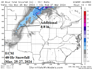
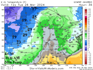
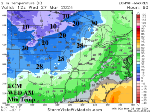
Fig. 3-5: The ECM additional snowfall forecast for the North-central U.S. snowstorm and following cold TUE and WED morning low temperatures.
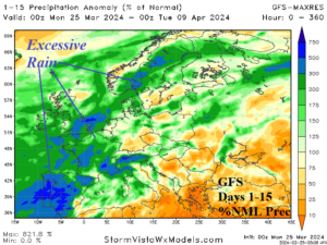
Fig. 6: The GFS 15-day percent of normal precipitation forecast across Europe and Western Russia.