
Is Wet Forecast for the Central U.S. too wet? Western Plains Trend Drier.
04/07/2026, 8:16 am EDT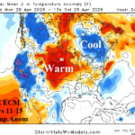
NOAA/CPC Forecasts -NAO/-AO Days 11-15 Favoring Cooler Quebec/New England (ECM) Outlook
04/10/2026, 4:13 pm EDT
Climate Impact Company Early AG Market ALERT
Issued: Wednesday April 8, 2026
Highlight: Central U.S. rainfall forecasts generally too wet, best support is farther east, after 10 days could go dry. Brazil turns wet; Few showers Europe.
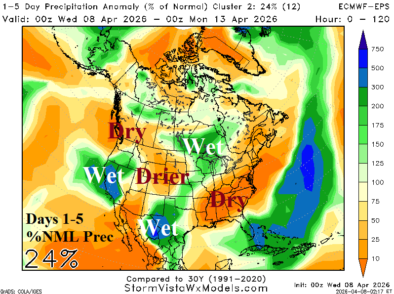
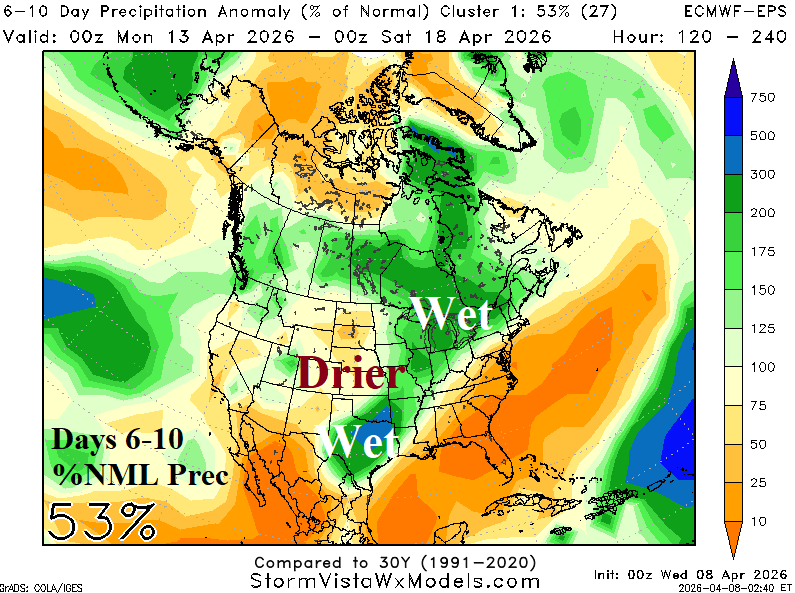
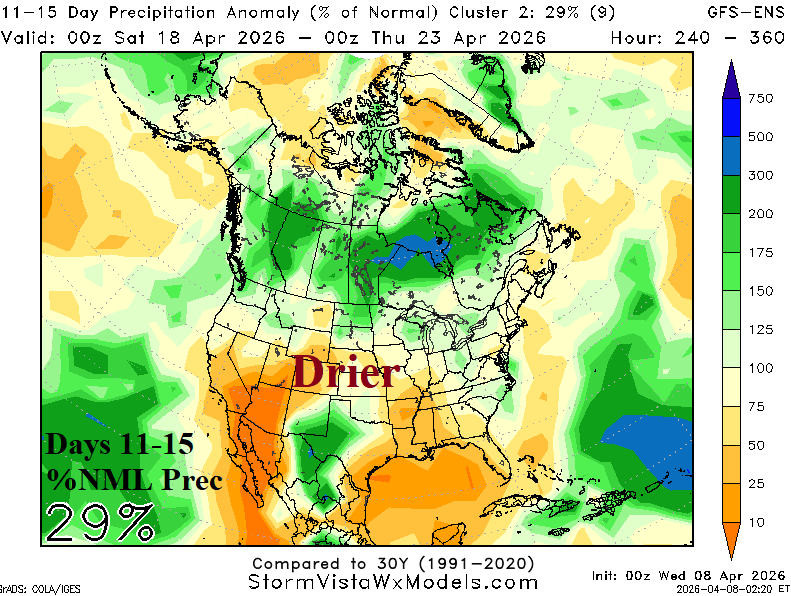
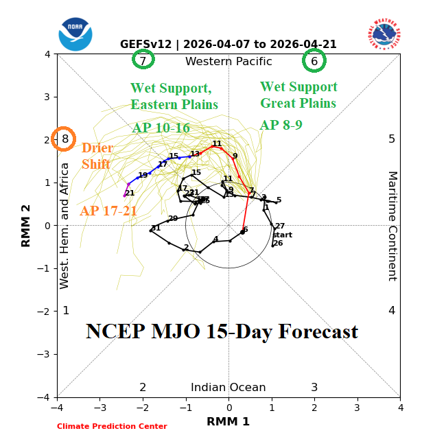
Fig. 1-4: Using the ECM ENS mega-cluster ensemble to project U.S. rainfall the next 10 days (GFS ENS version days 11-15). The model choice is based on MJO phase as indicated by the 15-day outlook from NCEP.
Discussion: Support for excessive rainfall in the Central U.S. during the next 15 days is below average. To produce excessive rainfall, tropical forcing performed by presence of Madden Julian oscillation (MJO) influence is necessary. The MJO is positioned to influence Central U.S. rainfall the remainder of this week. Consequently, thunderstorm development bordering on severe intensity is present in the central Great Plains WED-FRI and shifts farther south this weekend. The “best” forecast to indicate the wet weather pattern through the weekend is the ECM ENS mega-cluster. Heaviest rain is in Texas but note western Great Plains areas such as drought-parched Nebraska miss the rain (Fig. 1). In the 6-10-day period, MJO shifts to phase_7 which traditionally supports heavy rain in the Southeast U.S. So, picking a forecast with the farthest eastward bias of rainfall in the 6-10-day period is implied. Once again, ECM ENS mega-cluster ensemble has the arc of heavier rain from Texas toward Missouri and into the Great Lakes region leaving the western Great Plains drier, possibly more so than forecast (Fig. 2). MJO support fades in the 11-15-day period. The driest forecast for this timeframe is the “best” outlook. GFS ENS mega-cluster ensemble leaves Western Texas wet while most of the U.S. is near to drier than normal (Fig. 3). GFS and ECM have developed a too wet forecast bias during the past week centered on Illinois, strongest bias by ECM. The MJO dictates excessive rainfall, and the 15-day outlook (Fig. 4) indicates short-term support for heavy rain fading fast during the medium range.
MJO (wet) influence should appear in the South America climate through the middle third of April. Utilizing AIFS ENS, the wet bias is across Southwest Brazil to North Argentina and possibly Northeast Brazil (Fig. 5). Helping to add excessive rainfall risk to the wet forecast areas is the link to tropical moisture across the warm Nino12 SSTA region.
The Europe/Western Russia 15-day precipitation outlook remains similar thematically to yesterday with the wet bias in the Eastern Black Sea/Southwest Russia region and eastward while Europe is mostly dry (Fig. 6). However, some patchy shower activity is present in Europe particularly Germany/Poland in the 15-day outlook.

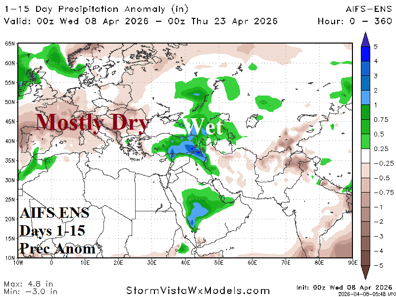
Fig. 5-6: AIFS ENS 15-day precipitation anomaly forecasts across South America and Europe/Western Russia/Middle East.