
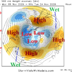
+AAO Pattern Responsible for Wet Weather in Australia and Brazil
11/09/2026, 12:52 pm EST
November 2026 Climate Impact Company ENSO Outlook
Issued: Tuesday November 10, 2026
Highlight: Super El Nino peaking. Expecting rapid demise during early 2027.
Executive summary: Has Super El Nino 2026-27 peaked? What follows Super El Nino? Of course, forecast model opinion varies. However, the recently developed observed and forecast choppy southern oscillation index suggests the oceanic and atmospheric Super El Nino is peaking now. The eastward push of cool subsurface water east of the Dateline suggests that while fuel to sustain Super El Nino for boreal winter 2026-27 remains buoyant, an ending to warm ENSO is on the horizon. Climate Impact Company prefers the CFS V2 and RONI-analog ENSO phase forecasts which indicate Super El Nino 2026-27 peaks in November and weakens rapidly in early 2027 flipping to La Nina middle 2027.
Discussion: The subsurface equatorial Pacific Ocean temperature anomalies identify the “potential” for ENSO phase ahead (Fig. 1). The record warmth in the East Pacific subsurface is the buoyant fuel to energize the strongest El Nino on record for boreal winter 2026-27. However, cooler waters in the West Pacific subsurface are advancing eastward and past the Dateline. If the progressive nature of the cooler waters continues, an end of Super El Nino is on the horizon.
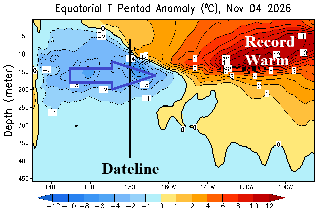
Fig. 1: Equatorial Pacific Ocean subsurface upper ocean temperature anomalies.
Day-to-day, the southern oscillation index (SOI) is the best way to identify Super El Nino intensity and trend. Long-standing vigorous -SOI, representing Super El Nino, ended during the last third of October (due to influences of the Madden Julian oscillation). For about 10 days, SOI was neutral to weak positive (Fig. 2) indicating both oceanic and atmospheric Super El Nino intensity leveled off. However, during the first third of November, moderate-strength El Nino -SOI has regenerated. Will SOI settle back into long-standing negative phase supporting Super El Nino intensification? The latest 15-day SOI forecasts doubt intensification as the SOI shifts positive again for middle November (Fig. 3).
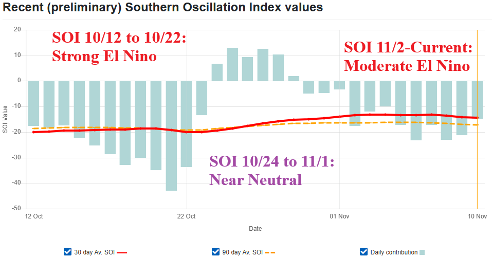
Fig. 2: Equatorial Pacific Ocean subsurface upper ocean temperature anomalies.
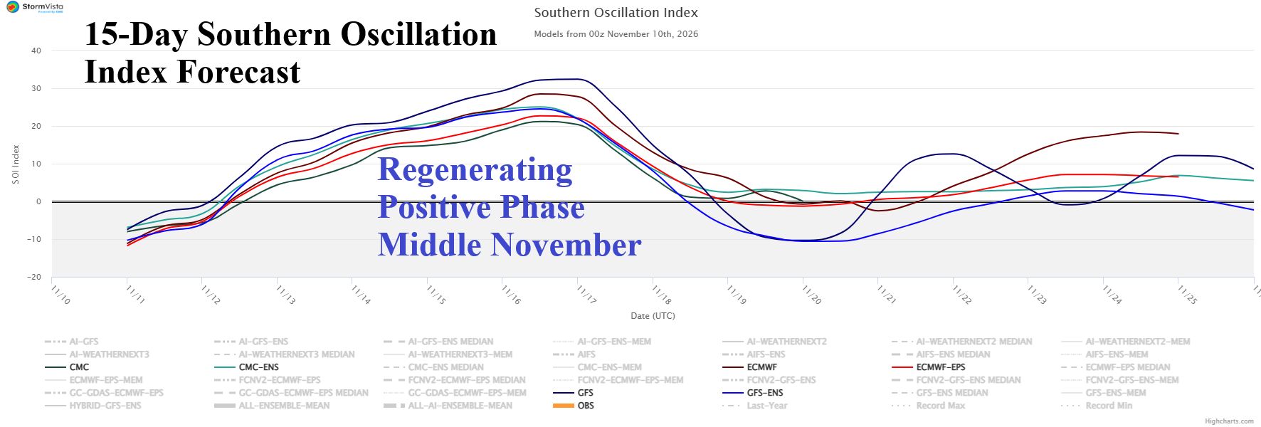
Fig. 3: Equatorial Pacific Ocean subsurface upper ocean temperature anomalies.
Implied is the peak of Super El Nino 2026-27 may have occurred. Lead operational relative Nino34 SSTA forecasts each agree that Super El Nino carries through early 2027 followed by a steady intensity decline into Q2/2027. However, CFS V2 suggests peak Super El Nino occurs now (Fig. 4) while POAMA and ECMWF prefer December (Fig. 5-6). Interestingly, CFS V2 shifts ENSO into neutral phase as early as May 2027 while POAMA and ECMWF maintain a strong El Nino at that time. The Climate Impact Company analog forecast relies on the relative operational Nino index (RONI) which reveals steady Super El Nino intensity through December followed by weakening to below Super El Nino criteria in FEB-27, weak El Nino by APR-27, and La Nina by the middle third of 2027 (Fig. 7). The eastward shift of cooler than normal water east of the Dateline now, suggest that an abrupt ending to Super El Nino in 2027, as supported by CFS V2 and CIC analog, is possible.
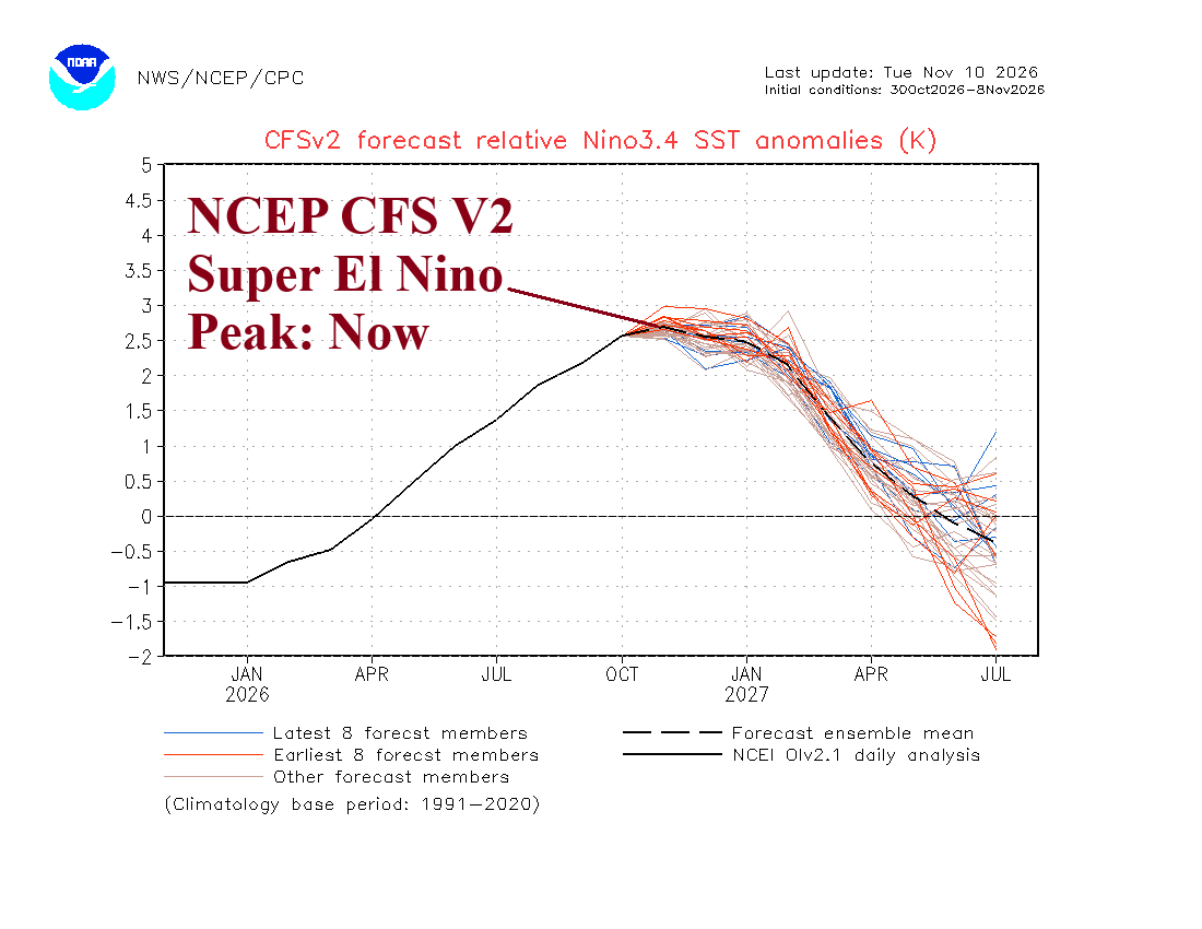
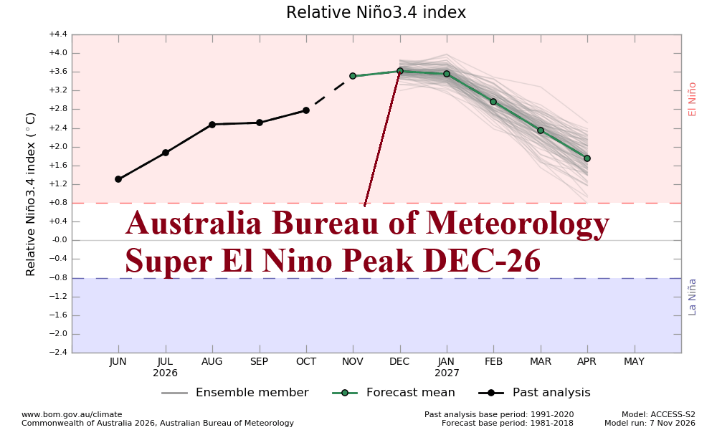
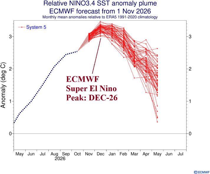
Fig. 4-6: The relative Nino34 index forecast to determine ENSO phase and intensity by NCEP CFS V2, POAMA, and ECMWF.
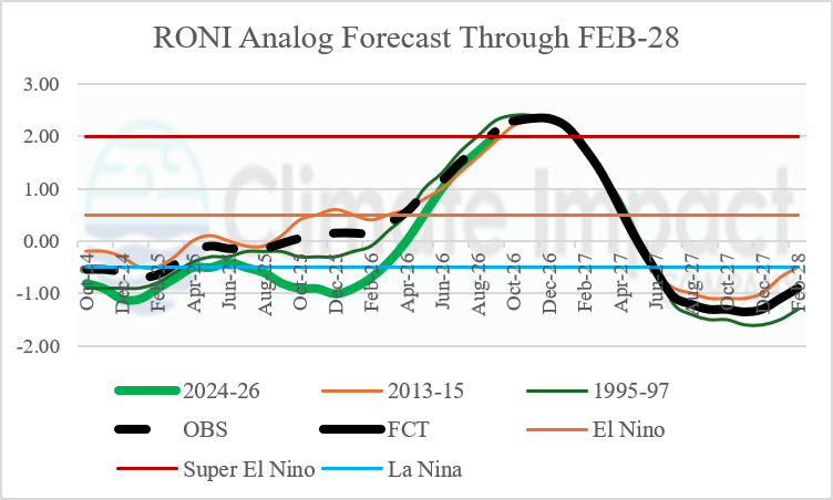
Fig. 7: The Climate Impact Company ENSO phase forecast utilizing relative operational Nino index.