Sharply Cooler Equatorial East Pacific Subsurface Offers La Nina Energy if Tradewinds are Sustained
09/25/2024, 10:53 am EDTMostly a Dry and Warm Week 2-4 U.S. Forecast
09/26/2024, 8:49 pm EDT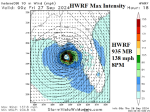
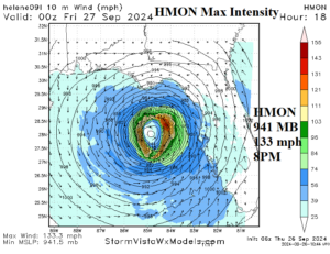
Fig. 1-2: HWRF and HMON max intensity forecast for Hurricane Helene.
Discussion: At 8AM EDT, Hurricane Helene was located at 24.5N/85.9W or about 320 miles southwest of Tampa, FL. Helene is moving north-northeast at 12 mph with top sustained wind near 100 mph. Central pressure is 960 MB.
Hurricane models (HWRF and HMON) initialize the 8AM EDT central pressure at 952-953 MB, so slightly too strong. HWRF takes Helene to a 935 MB/138 mph category-4 major hurricane by 8PM this evening with landfall across the Apalachee Bay area late this evening (Fig. 1). HMON is not quite as strong, indicating 941 MB/133 mph category-4 major hurricane at 8PM this evening with landfall shortly after midnight in the Apalachee Bay area (Fig. 2). The hurricane models insist on a category-4 major hurricane, although each model is too strong at initialization. Additionally, each model is 2-4 hours later for landfall, most focused on late evening to just after midnight. NOAA/NHC may delay landfall slightly in their 11AM EDT updated. The largest (of many) concerns are the storm surge generated by a fast-developing major hurricane while approaching the coast implicating much of the west coast of Florida particularly the Big Bend region where a 15-20-foot surge is forecast.
Weather satellite view of Hurricane Helene reveals an evolving eye with “feeder bands” most prevalent north and northeast of the storm (Fig. 3). The upper trough guiding Helene north-northeastward is vividly observed over the northwest Gulf of Mexico.
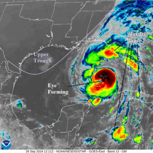
Fig. 3: Recent weather satellite view of Hurricane Helene.