NAWH In Control of NA/EU Weather Pattern
08/11/2024, 11:19 am EDTRemains of Ernesto Gust Across Ireland/U.K. Thursday
08/18/2024, 12:02 pm EDTHighlight: East-central Europe ridge to emerge.
Charts of the day: Drier Southwest Europe, Super marine heatwave Norwegian Sea.
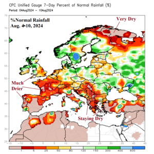
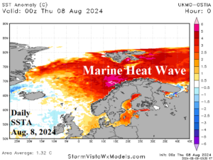
Discussion: After a long duration mostly wet pattern across Western Europe dating back to last autumn, early August brought widespread dryness including France where rains have caused poor grain conditions. Note that gigantic marine heat wave north of Europe associated with high pressure ridging.
Week-2 Ahead Forecast valid August 18-24, 2024: Upper ridge anchored on East-central Europe.
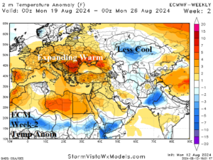
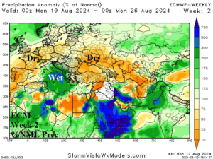
Discussion: ECM indicates an upper trough extends across the Norwegian Sea MHW which could ignite major rainfall, not indicated, for Northern Europe. To the south, an upper ridge crests over Central Europe causing dry and very warm to hot weather from Spain to Romania to Ukraine. An upper trough in the Central Mediterranean Sea causes heavy rains in Italy.
Week-3 Ahead Forecast valid August 25-31, 2024: East-central Europe upper ridge!
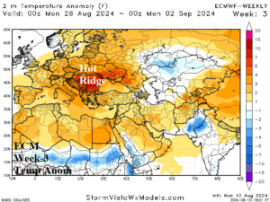
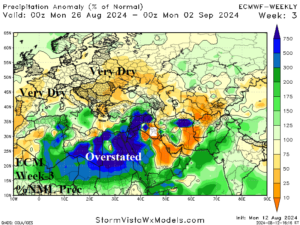
Discussion: ECM amplifies the East-central Europe ridge. Consequently, significant heat is expected over the eastern half of Europe. Dryness accompanies the hot weather. The green wet depiction in Africa may be overstated although makes the point that tropical moisture flowing westward toward the Atlantic tropics (to fuel tropical cyclones is buoyant).
Week-4 Ahead Forecast valid September 1-7, 2024: The ridge pattern is weakening.
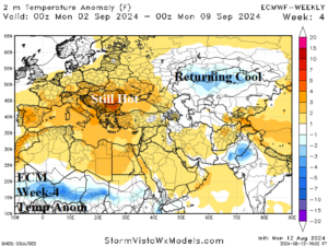
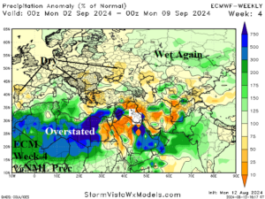
Discussion: Upper ridge shifts to Western Europe and weakens. The upper trough responsible for mid-to-late summer rains across Russia’s spring wheat crop regains strength.