IOD Likely to Stay Neutral Well Into 2025
09/24/2024, 4:54 am EDTHelene is Inland; Widespread Dangerous Weather Persists
09/27/2024, 6:12 am EDTHighlight: Helene makes landfall 9-10PM across eastern Apalachee Bay as a categpry-4 major hurricane. An immense storm surge is generated by this storm.
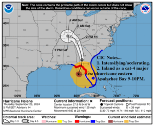
Fig. 1: Latest NOAA/NHC 3-day forecast track for Category-3 Major Hurricane Helene
Discussion: At 5AM EDT, Category-3 Major Hurricane Helene was located at 27.9N/84.6W or about 130 miles west of Tampa and 175 miles south of Tallahassee. The maximum sustained wind is 125 mph, and Helene is accelerating to 23 mph toward the north-northeast. Central pressure is 951 MB. Helene is developing rapidly while accelerating. An exceptionally violent storm. The consensus of hurricane forecast models takes Helene to a category-4 major hurricane prior to landfall. The landfall location is across eastern Apalachee Bay in the 9-10PM timeframe. An eye has formed and is “clearing out” according to NOAA. The storm is unusually large and hurricane force weather will extend a great distance from the center, particularly to the east of the track. The hurricane continues to strengthen approaching the coast and forces a piling storm surge that will cover a large portion of northwest Florida with impressive water rise extending down the coast well south of Tampa. Extreme rain causes flash flooding from the eastern Florida Panhandle to the southern Appalachians. Tornadoes are a major issue with this storm. Three tornado watch areas are posted from Florida to South Carolina now. Tornado risk extends across all the Carolinas on Friday. Helene will travel well into Georgia before weakening to a tropical storm after dawn Friday in northern Georgia. Helene is entrained into an upper low-pressure trough weakening in the northern Tennessee Valley this weekend. High wind will extend to the south/central Appalachians and Ohio Valley.
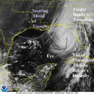
Fig. 2: Weather satellite view of Helene from mid-afternoon.
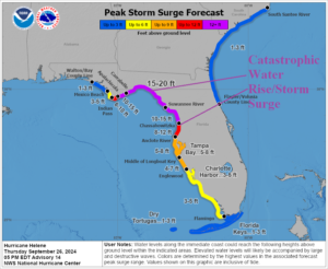
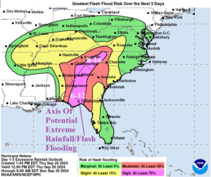
Fig. 3-4: NOAA/NHC storm surge and flood forecast.
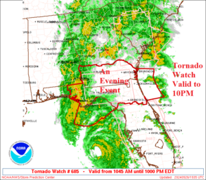
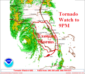
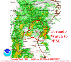
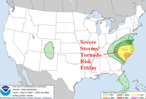
Fig. 5-8: Current NOAA/SPC tornado watch areas and the severe weather/tornado risk area for tomorrow.
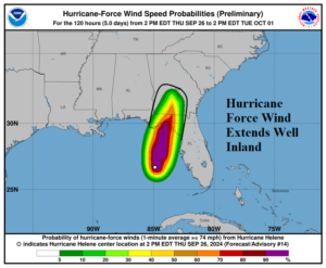
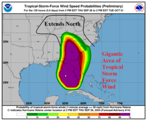
Fig. 9-10: The latest hurricane and tropical storm force wind probability forecast from NOAA/WPC.