August 2025 U.S. Soil Moisture Observations/Outlook
08/18/2025, 5:03 am EDT
North Atlantic Tropics: SEP/OCT/NOV Should Become Active!
08/24/2025, 9:16 am EDT![]()
Climate Impact Company Operational AI/Research Report
Issued: Tuesday, August 19, 2025
Highlight: Explaining why “weeklies” have performed temperature forecasts poorly during summer 2025.
Executive summary: Climate Impact Company offers explanation for why North America 16-30-day (week-3/week-4) temperature forecasts have routinely produced very warm bias. Unusual presence and persistence of a summertime Northeast Canada polar vortex and convection phase Madden Julian oscillation (MJO) stretched across the tropical Pacific Ocean are the culprits significantly contributing to East U.S. heat and occasional historic rainfall events. Up until now, most of the significant heat during summer 2025 has anchored in the East U.S. leaving the West less hot (and sometimes cool). The “weeklies” have done a reasonable job forecasting the East U.S. heat. However, hot forecasts for the West have (mostly) failed.
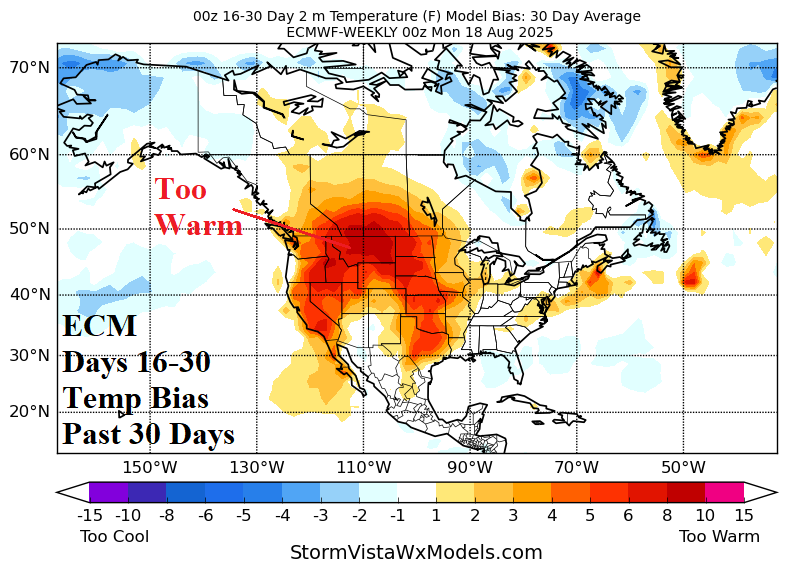
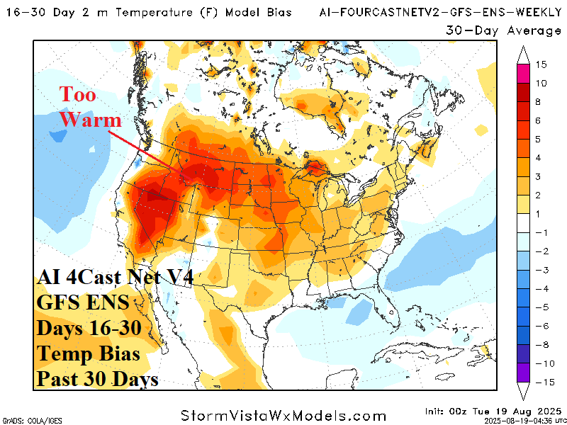
Fig. 1-2: Temperature forecast bias during the 16-30-day period by the ECM and AI 4Cast Net V2 GFS ENS for the past 30 days.
Discussion: During the past 30 days, and for much of meteorological summer 2025, 16-30-day forecasts (presented in week-3/week-4 ahead format) have typically been too warm. As examples, the most common forecast model for this time frame (ECM “weeklies”) has produced very strong warm bias across much of the western half of the U.S. except the Southwest States (Fig. 1). AI models have produced similar results. The AI 4Cast Net V2 GFS ENS warm forecast bias extends across most of the U.S. (Fig. 2). Forecast errors are as much as 10F (or more) across the Intermountain Northwest.
A possible explanation is the uniqueness of the meteorological summer 2025 climate having tendency to persist into the extended range rather than change as “weeklies” models try to forecast. Two climate features have dominated influencing the North America summer 2025 climate: 1.) Polar vortex across Northeast Canada (Fig. 3) and 2.) Persistent convection phase of the Madden Julian oscillation (MJO) across the tropical Pacific Ocean (Fig. 4).


Fig. 3-4: Temperature forecast bias during the 16-30-day period by the ECM and AI 4Cast Net V2 GFS ENS for the past 30 days.
Speculated is the origin of the persistent and unusual summertime polar vortex across Northeast Canada as a leftover mid-troposphere feature from a late calendar winter stratospheric warming episode. Beneath the trough, SSTA south and west of Greenland cooled helping to sustain and enhance the upper trough during mid-summer. The link of the polar vortex to U.S. weather is a persistent hot upper ridge in the East with an occasional trough in the West which, when present, produced high impact wet weather episodes enhanced by the Pacific MJO influence delivering historic rains to parts of the Midwest, Texas and East U.S. at times during the summer season. The uniqueness of these climate scenarios renders extended range models, including AI forecasts, to have increased error due to the lack of memory of this type of weather pattern.