Excessive Heat Argentina, Hot Pattern Australia, Heavy Precipitation Returns to Europe, China chill.
01/28/2024, 1:16 pm ESTArctic Air Watch for 3rd Week of February Issued
01/31/2024, 2:48 pm ESTHighlight: Brazil drought shifting south toward Argentina.
Executive Summary: The inaugural year-2 ahead climate forecast for South America is issued. The forecast is valid for meteorological autumn 2025 through summer 2025-26. Forecast highlights include a strengthening Brazil drought shifting southward into Northeast Argentina.
Climate summary: As discussed in the South America season 1-4 ahead climate summary, the projected ENSO phase for 2025 is La Nina with varying intensity. La Nina is likely to continue through the southern hemisphere summer 2025-26 season. Oceanic warming either side of South America increases in 2025 and the influence on climate by these warm SSTA conditions is averaged with historical La Nina conditions to generate the year-2 outlook.
Forecast methodology: The forecast is based on a constructed analog that equally weighs the influence of the 2014-23 oceanic warming across the South Pacific and South Atlantic with modern-day La Nina climate.
MAR/APR/MAY 2025: Meteorological autumn 2025 upper air pattern features a semi-permanent upper trough well east of Southeast Brazil while an amplified upper ridge stretches across Central Argentina with two centers either side of the continent. The prevailing climate given this set-up is a variable thermal pattern across both Brazil and Argentina averaging near normal for the season. Central and Southeast Brazil are drier than normal as Brazil drought continues given this rainfall outlook. Northern continent is wet while Argentina observes mixed conditions with wet climate northwest and a dry regime northeast extending across Uruguay.
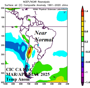
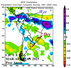
Fig. 1-2: The Climate Impact Company constructed analog forecast for temperature and precipitation anomalies during MAR/APR/MAY 2025 across South America.
JUN/JUL/AUG 2025: The prevailing upper air pattern for meteorological winter 2025 is concerning. More so than the winter 2024 forecast, an amplified upper trough is located off the South Coast of Chile and stretches southwestward toward the Amundsen Sea off the Antarctic Coast. Another equally amplified trough is east of Uruguay. If the trough patterns merge during the winter season, an exceptionally chilly air mass could evolve across Argentina and extend northward into Brazil (at times). Consequently, risk of dangerous cold into South Brazil for winter 2025, is above normal for the second consecutive winter. North of this risk, Brazil averages warmer than normal for the winter season. Argentina and especially Chile average cooler than normal.
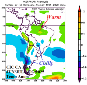
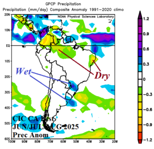
Fig. 3-4: The Climate Impact Company constructed analog forecast for temperature and precipitation anomalies during JUN/JUL/AUG 2025 across South America.
SEP/OCT/NOV 2025: During spring 2025, a dry climate emerges across southwest and southeast portions of Brazil. North/Northeast Brazil is wet. The Brazil drought is shifting southward. Northeast Argentina also shifts drier. Anomalous heat is forecast for Central/Northwest Brazil while a cooler than normal bias exists over Southeast Brazil to North Argentina.
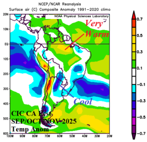
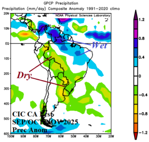
Fig. 5-6: The Climate Impact Company constructed analog forecast for temperature and precipitation anomalies during SEP/OCT/NOV 2025 across South America.
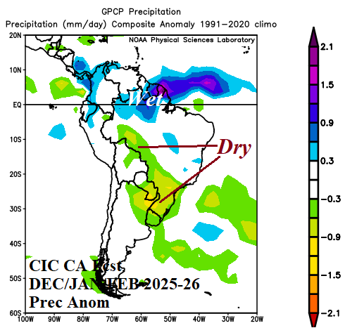
DEC/JAN/FEB 2025-26: During meteorological summer 2025-26 a major drought is implied in Northeast Argentina and Southeast Brazil by a dry and hot climate forecast in these areas. Prior to summer, southern portions of Brazil are already in drought. Consequently, accelerating drought due to a hostile climate pattern is easily attained. Much of Argentina is hotter than normal for the season. East Brazil is typically rainy with suppressed anomalous heat risk.
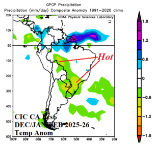
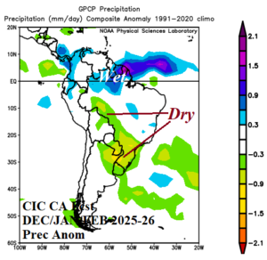
Fig. 7-8: The Climate Impact Company constructed analog forecast for temperature and precipitation anomalies during DEC/JAN/FEB 2025-26 across South America.

