
30-Day Skill Scores of U.S. Medium-range Temperature Anomaly Forecasts
08/14/2025, 7:56 am EDT
West Africa Cocoa Update…Cocoa-Growing Areas Drought Continues
08/20/2025, 5:40 am EDT
Climate Impact Company North Atlantic Basin 10-Day Monitor
Issued: Monday August 18, 2025, 8:45AM EDT
Highlight: Tracking East Coast impacts from Erin. Erin strengthens today.
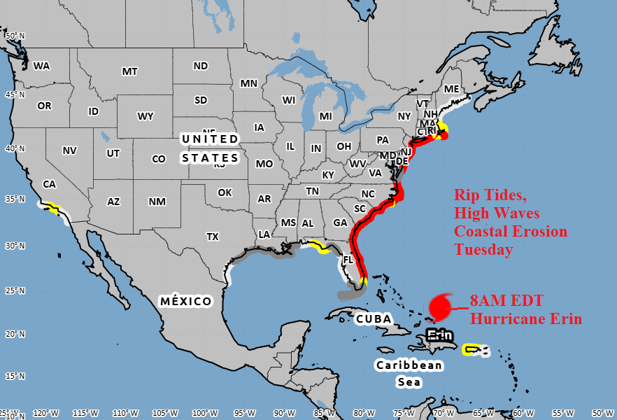
Fig. 1: NOAA/NHC TUESDAY rip tide forecast and likely areas for increasing and/or high waves and onset of beach erosion.
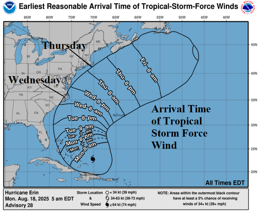
Fig. 2: NOAA/NHC timing of the arrival of tropical storm force wind.
Discussion: Primary impacts on the U.S. East Coast by Hurricane Erin are riptides beginning today and becoming widespread on Tuesday (Fig. 1). In the riptide area, increasing and/or high waves and onset of beach erosion is likely. The conditions which become widespread tomorrow will continue through Thursday. The onset of tropical storm force wind is Wednesday for coastal North Carolina and possibly Nantucket and Martha’s Vineyard on Thursday (Fig. 2). Most of the heavy rain associated with an expanding Erin as the storm moves north and northeast this week stays offshore.
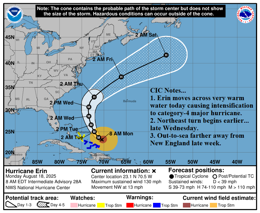
Fig. 3: NOAA/NHC 5-day forecast track for Hurricane Erin.
At 8AM EDT, Hurricane Erin was located at 23.1N/70.5W or about 115 miles north-northeast of Grand Turk Island. Erin is moving northwest at 13 mph with top wind near 130 mph and central pressure 933 MB. Erin is gaining strength and increasing in size. Hurricane force gusts extend to 70 miles from a 30-mile-wide eye and tropical storm force wind reach 200 miles from the center of the storm. Erin will become a strong category-4 major hurricane today in a light shear environment and warmer water (86-87F). Intensification to near category-5 is possible, given the warm water. A weak upper trough over the eastern Gulf of Mexico has produced some southwest shear to the west and north of Erin which could initiate weakening late tonight or tomorrow. However, Erin maintaining category-4 status tomorrow would not surprise given the very warm water. The “real” shear turning Erin out-to-sea arrives Wednesday night and northeast acceleration follows (Fig. 3). The storm is trending farther away from the Northeast U.S. later this week.
Trailing Erin is a potential new tropical disturbance located in the east-central North Atlantic tropics (Fig. 5). This system is forecast to track west to west-northwest over the next 5 days, possibly becoming a tropical cyclone approaching Puerto Rico by early weekend.
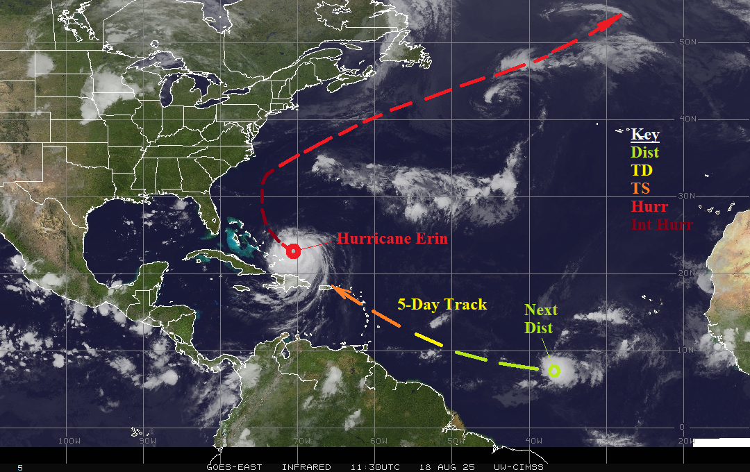
Fig. 4: North Atlantic basin weather satellite view.