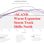
Scandinavia Index Reverses, Allows Europe to Warm/Turn Drier
02/19/2026, 9:16 am EST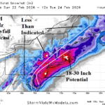
Northeast U.S. Blizzard; High Wind/Coastal Flooding/Widespread Power Outages
02/22/2026, 1:26 pm EST
Climate Impact Company Early U.S. Notes
Issued: Friday February 20, 2026
Highlight: Climate signals support warmer medium range forecast. However, short-term potent high wind/heavy snow event forecast for SUN/MON Northeast Corridor Coast.
Climate signals discussion: The strongest climate signal signatures for the 6-10-day period are positive phase of both the North Atlantic oscillation and East Pacific oscillation. Pacific North America index remains negative. At face value, the combination cited supports a cold/stormy West and warm Central/East weather pattern. Today’s operational 6-10-day forecasts are agreeable except lingering cool over Florida and possibly New England (due to snow cover). In the 11-15-day period, climate signals are weaker except for lingering positive phase of the East Pacific oscillation which on its own supports a warm central North America weather pattern which is (strongly) indicated by operational models.
Verification: During the winter season, the occasional sharp cold bursts into the East were well forecast 4 weeks in advance by AI models. Similarly, today’s warm medium range forecast was (also) well forecast by AI models several weeks in advance. This observation clears AI projections of early assumptions that the (AI) models have a cold bias in the extended range.
ENSO/SSTA discussion: Southern oscillation index (SOI) has been positive, a sign of lingering La Nina climate. However, daily SOI shifts to near zero (neutral) today. Implied is Maden Julian oscillation phase_3/phase_4 (Maritime Continent) location is trying to shift eastward. Forecast models shift MJO eastward into the equatorial West Pacific during the next 2 weeks but weaken the intensity. Therefore, the east-shifting MJO warm influence on U.S. climate for late FEB/early MAR is diminished and MJO-driven warming of the eastern equatorial Pacific lowers. However, notable is the surge in warming of the subsurface equatorial East Pacific increasing El Nino risk for Q2/2026.
Today’s weather discussion: Tendency for West U.S. weather hazards continue with additional hazards emerging in the East to close this week. In the wake of storms this week, cold air settles on California prompting a Freeze Warning in the San Joaquin Valley (and vicinity) with lingering high wind in Southern California (Fig. 1). Heavy snow is likely in coastal mountain areas of Southern California. Recent and ongoing heavy snow initiates Avalanche Warnings in Utah and Colorado. High wind causes Red Flag Warnings in far western portions of Texas. A Winter Storm Warning for heavy snow is issued for Iowa to Wisconsin with a Wind Advisory spread across the Ohio Valley. Dense fog hampers shipping out of Houston and Norfolk. Rain and snowmelt cause Flood Watch issuance in West Virginia and Southwest Pennsylvania. A Winter Storm Warning for heavy snow is issued for Vermont and New Hampshire.
Negative West Pacific oscillation is famous for producing significant cold across South-central Asia. Currently, arctic air is amassing in this region and may shift east to strike China to close February. Additionally, this pattern has a cold bias in the East U.S. Snow events are likely for the Northeast/Mid-Atlantic region into early next week. The first event is today/tonight as ECM projects 4-8 inches of snow across New York and New England. Details of a late weekend/early next week storm for the Coastal Northeast Corridor are uncertain. GFS forecasts a hostile 958 MB low pressure area during Monday afternoon southeast of Nantucket while ECM is near 972 MB at the same location. NOAA/WPC forecasts 0.75 to 1.50 in. of quantitative precipitation for the Coastal Northeast Corridor and given the intensity of this storm, through vertical motion, most of this precipitation should be sleet and snow. The 48-hoour snowfall forecast by NBM indicates widespread risk of 6-12 inches of snow for the coastal states of the Northeast Corridor (Fig. 2). ECM is slightly less and GFS is much more with snowfall totals.
Given the low-pressure forecasts, high wind is a major issue with this storm. Utilizing the aggressive GFS forecast, wind gusts in the 45-65 mph range should be expected Sunday evening on the Mid-Atlantic Coast extending inland to I-95 (Fig. 3). By late Monday morning, wind gusts approach hurricane force across southeastern Massachusetts (Fig. 4). High wind and heavy snow combination could produce blizzard conditions.
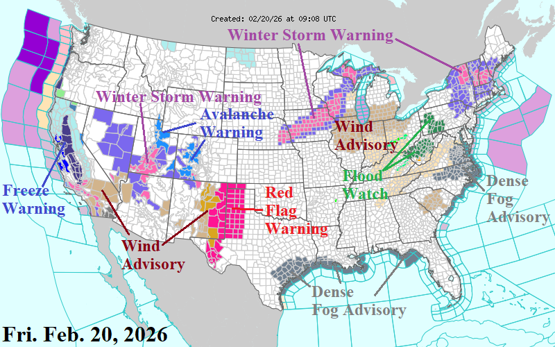
Fig. 1: The NOAA/NWS weather watch, warning, and advisory areas.

Fig. 2: The NBM 48-hour snowfall forecast for the SUN/MON Northeast Coastal snowstorm.

Fig. 3: The GFS maximum wind gusts for the Mid-Atlantic region.
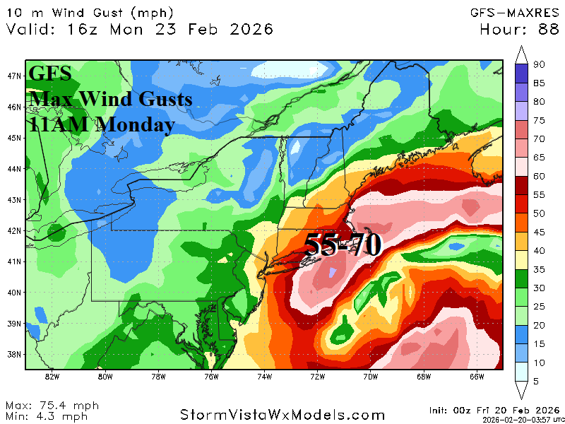
Fig. 4: The GFS maximum wind gusts for the New England region.