
West Africa Cocoa Update…Cocoa-Growing Areas Drought Continues
08/20/2025, 5:40 am EDT
Europe Drought to Receive Beneficial Rainfall
08/24/2025, 11:45 am EDT
Climate Impact Company Tropical Feature
Issued: Thursday August 21, 2025
Highlight: A look at 99L and 90L and Erin’s effect on SST.
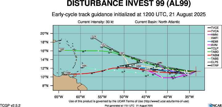
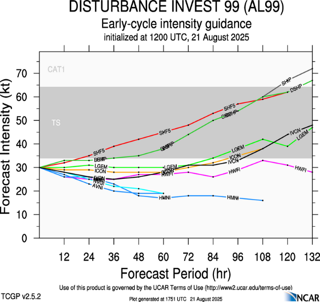
Fig. 1-2: Projecting maximum Erin intensity and East Coast exposure to high
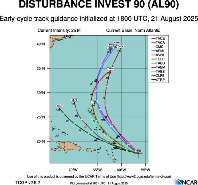
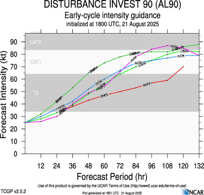
Fig. 3-4: Projecting maximum Erin intensity and East Coast exposure to high
Discussion: At 2PM EDT Hurricane Erin was located at 35.6N/70.5W or about 400 miles northwest of Bermuda. Erin is moving northeast at 18 mph with top wind 100 mph and surface pressure 952 MB. Erin is a huge storm with lingering effects on the Mid-Atlantic Coast despite many 100’s of miles away. A Storm Surge Warning remains in effect for Cape Lookout to Duck, NC. A Tropical Storm Warning remains in effect for Beaufort Inlet, NC to Chincoteague, VA, and Bermuda. Tropical storm force gusts are likely for Southeast Massachusetts tonight.
We’re looking at two new issues: Tropical Disturbance 99L located off the West Coast of Africa and Tropical Disturbance 90L just east of the northeast Caribbean Sea. 90L is forecast to drift westward with a 40% chance of developing into a tropical storm (Fig. 1-2). However, 99L is more likely to become a tropical storm (70% risk) turning northward later weekend into early next week (Fig. 3) with chance of becoming a minimal hurricane according to tropical cyclone models (Fig. 4).
On a related note, Erin has significantly cooled the ocean surface east of the Bahamas (Fig. 5). SST in the core of the cooler zone are 80-81F, below the threshold to sustain a tropical cyclone. The 7-day SST change in near 2.5C due east of the Bahamas (Fig. 6). To the north of Puerto Rico, north of 25N, the SST are somewhat warmer than normal which explains the potential hurricane intensity of tropical cyclone models for 90L.
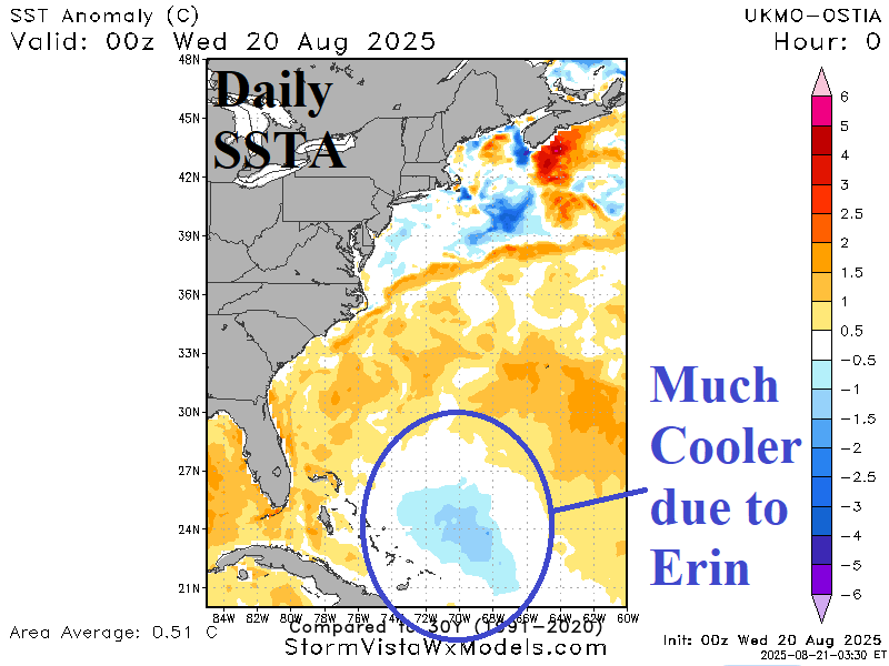
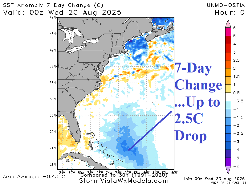
Fig. 5-6: Western North Atlantic basin sea surface temperature anomalies and 7-day change.