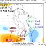
South America Weather Pattern Change In December
11/25/2025, 4:35 am EST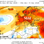
Europe Week 2-4 Outlook: Lack of Snow Cover Helps to Inspire Warm December
12/02/2025, 9:38 am EST
Climate Impact Company Madden Julian Oscillation Outlook
Issued: Sunday, November 30, 2025
Highlight: Stalled MJO in November responsible for late season tropical cyclones Senyar and Ditwah slowly weakens shifting eastward.
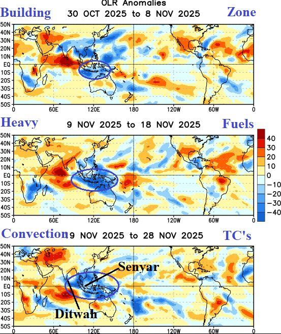
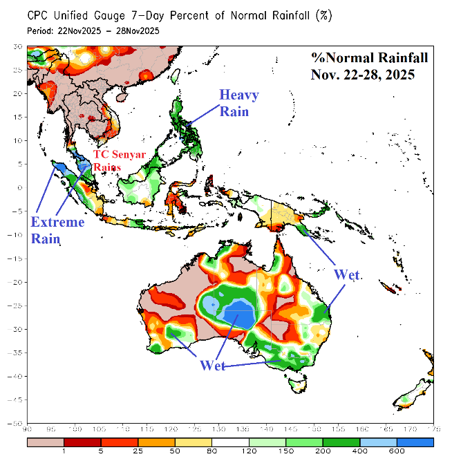
Fig. 1-2: The outgoing longwave radiation anomalies in the tropics/subtropics for November (blue represents heavy thunderstorms in the tropics) plus the percent of normal rainfall for Nov. 22-28 across Southeast Asia to Australia.
Discussion: Building convection centered over the eastern tropical Indian Ocean and Maritime Continent initiated in early November, strengthened mid-November, and reached peak intensity during late November (Fig. 1). During peak intensity, 2 unusually late season topical cyclones formed including Senyar striking Western Indonesia and Ditmar moving into Southern India. Extreme rains caused historic flooding and mudslides killing 100’s in Western Indonesia (Fig. 2) with similar damage and fatalities confined to Southern India (Fig. 3). Note the patchy heavy rains in Australia during the past week. A stalled and gradually strengthening Madden Julian oscillation (MJO) convective zone north and northwest of Australia was a leading catalyst to the unusually intense late season extreme rains.
Lingering effects of MJO maintain a pattern of late season tropical cyclone risks including Tropical Storm Koto heading for Vietnam (Fig. 4), Tropical Depression 34 east of Malaysia, and lingering Tropical Depression Ditmar off the East Coast of India. Another system may develop and approach the Philippines late this week.
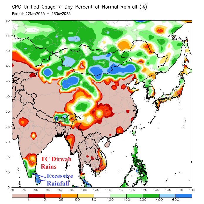
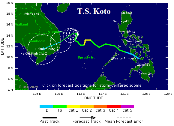
Fig. 3-4: The South Asia percent of normal rainfall observed for Nov. 22-28, 2025, and the 15-day Madden Julian oscillation forecast.
The latest 15-day Madden Julian oscillation (MJO) forecast indicates an eastward shift and weakening across the equatorial Pacific Ocean (Fig. 5). Unfortunately, due to the macroscale climate influences of La Nina, Indonesia maintains the wet climate well into December. The eastward shift of MJO has caused the daily southern oscillation index (SOI) to shift to negative phase. -SOI continues another 7-10 days before the MJO weakens after transiting the equatorial Pacific. During this time, trade winds across the equatorial East Pacific weaken causing the cool waters fueling the 2025 La Nina to weaken slightly.
The MJO eastward shift supports a drier climate across Australia and wetter for Brazil based on the latest GFS ENS 15-day rainfall anomaly outlooks (Fig. 6-7).

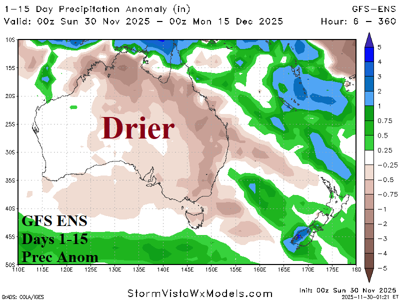
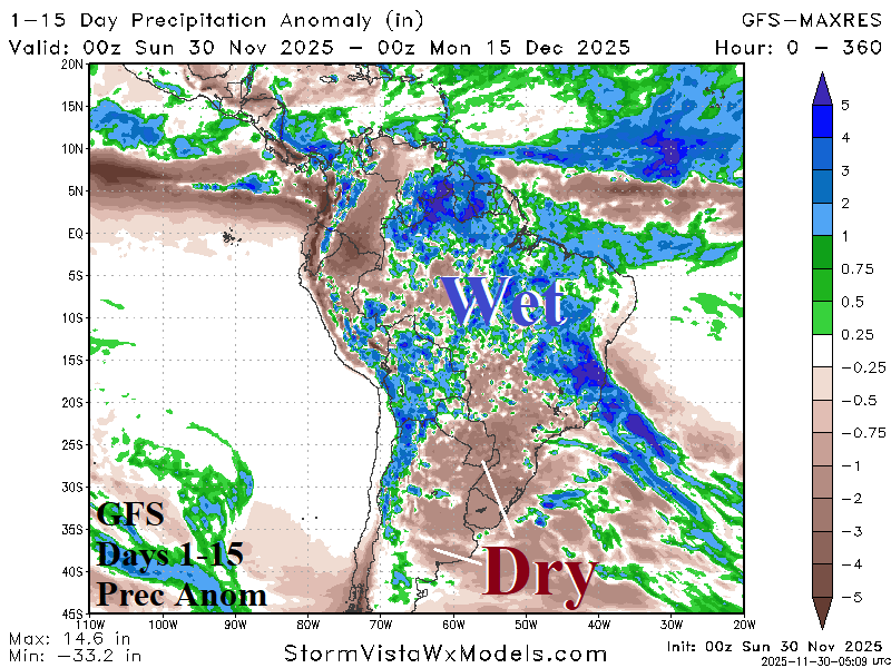
Fig. 5-7: The 15-day MJO forecast utilizing all models and the 15-day GFS ENS rainfall anomaly forecasts for Australia and South America.