Arid Northeast Argentina Pattern Shifts Much Wetter Mid-February
02/06/2026, 11:29 am EST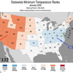
U.S. January 2026 U.S. Climate Report: Warm and Dry 2025-26 Cold Season So Far with Cold East Exceptions
02/10/2026, 11:31 am EST
Climate Impact Company AG Hot Spot
Issued: Sunday February 8, 2026
Highlight: Origin (and continuation) of the dangerous Southwest/South Europe storm track.
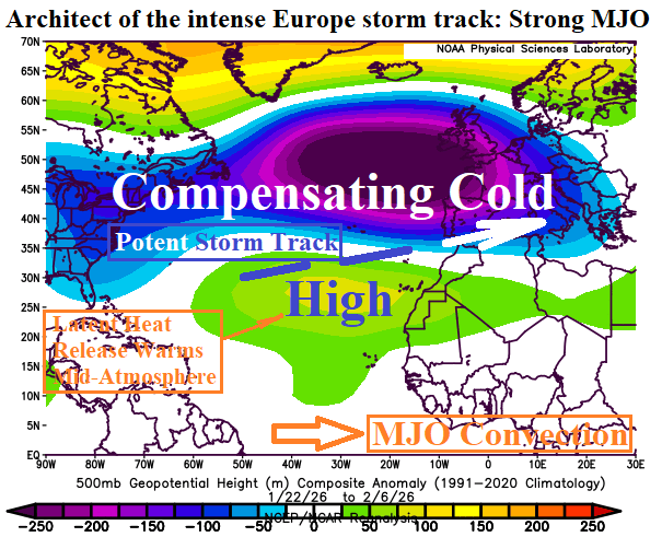
Fig. 1: The upper air pattern associated with the influential Madden Julian oscillation since January 21, 2026.
Discussion: Dramatic storm tracks are almost always associated with influence of the Madden Julian oscillation (MJO). The intense Southwest/South Europe storm track of the past 2-3 weeks is directly related to an eastward shift of the MJO across the equatorial East Pacific to tropical Africa. The deep tropics convection releases latent heat to the subtropics to cause a broad subtropical high-pressure ridge to form across the Southeastern North Atlantic basin. To compensate, a deep upper trough elongates from the Eastern United States across the Mid-latitude North Atlantic to Eastern Europe (Fig. 1). The elongated trough has caused storms to batter Southwest Europe extending eastward across Southern Europe (Fig. 2). Precipitation has exceeded 10 in. above normal on the Portugal/Spain border. The MJO influence is easing but the memory of the pattern stays intact for another 10 days. Equally combining GFS and ECM yields additional heavy rain across Portugal and Spain eastward to Italy and Greece (Fig. 3).


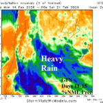
Fig. 2-3: The heavy precipitation pattern of the past 2-3 weeks across Southern Europe and the 10-day outlook.