Intense Heat and Dryness Ahead for Southeast Europe to Southwest Russia
07/01/2024, 1:14 pm EDTWill Beryl Reach Minimal Category-2 Hurricane Strength at Landfall?
07/07/2024, 8:23 am EDT
Fig. 1: The 12-week Nino region SSTA tracker indicates warming the past 1-2 weeks.

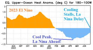
Fig. 2: The cooling upper ocean heat anomalies in the equatorial East Pacific has weakened the past 1-2 months.
Discussion: During the past week, the southern oscillation index (SOI) has turned very positive. The +SOI, if sustained, supports increasing trade winds to up-well cool subsurface water to inspire a La Nina trend. However, of late, the eastern equatorial Pacific has warmed. The Nino34 SSTA has returned close to the El Nino threshold (Fig. 1). In the subsurface equatorial Pacific Ocean east of the Dateline, the cool anomaly which peaked in April and implied La Nina development ahead has lost considerable intensity (Fig. 2). The La Nina 2024 forecast is in jeopardy. Forecast models maintain a La Nina outlook although generally delayed until later in the year.
