Will Beryl Reach Minimal Category-2 Hurricane Strength at Landfall?
07/07/2024, 8:23 am EDTSaharan Dust Stalls Tropical Development in North Atlantic
07/14/2024, 7:07 pm EDTWeek-1 Ahead (July 14-20): Cooler Central; Wetter Texas to Mid-Atlantic.
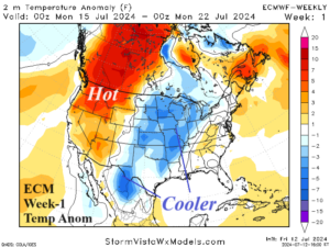
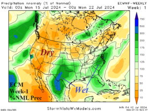
Discussion: A cooler pattern change is indicated for the Central U.S. next week primarily due to wet weather across Texas and the southern Great Plains. Heavy rains are also likely for the Mid-Atlantic region. Hot weather lingers in the West although coastal areas receive cooling relief.
Week-2 Ahead (July 21-27): Rainy Texas; Dangerous heat/dryness continues West.
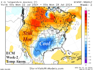
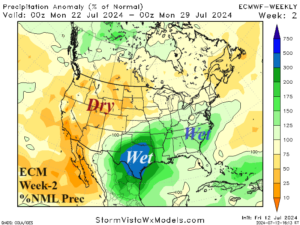
Discussion: The wet pattern across Texas continues and suppresses anomalous heat risk. The southeast quadrant of the U.S. is wet although tropical cyclone risk is not indicated. The anomalous hot weather remains in the West and could return to the California Coast.
Week-3 Ahead (July 28-August 3): Stays wet Texas; North-central U.S. warm-up.
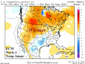
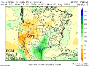
Discussion: The rains in Texas are relentless. Anomalous heat shifts off the West Coast and extends to the North-central U.S.
Week-4 Ahead (August 4-10): Western heat; Gulf of Mexico tropically active.
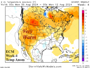
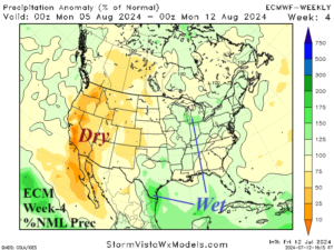
Discussion: The West U.S. heat and dryness continues into mid-August. The Gulf of Mexico may become tropically active and is likely to maintain wet risk in Texas. The East could be somewhat warmer than indicated.