Glance At 15-Day Temperature Forecasts for U.S. Energy Regions
01/12/2024, 8:53 am ESTFreezing Rain/Icing A Larger Concern for Texas/Louisiana
01/14/2024, 7:06 am EST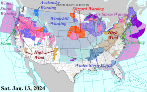
Fig. 1: NOAA/NWS weather watch, warning, and advisory areas.
Discussion: The northern 2/3 of the U.S. are receiving high impact weather to start the weekend. Another high wind/heavy rain and flooding episode is shifting across New England this morning (Fig. 1). Following this storm, westerly gales stretch across the Ohio Valley and into the Northeast Corridor for today. Another immense El Nino 975 MB low pressure system is in the eastern Great Lakes region this morning propelling the high wind. Additionally, a major Great Lakes snowstorm (named “Gerri”) will stretch to eastern New York today. Blizzard conditions should ease in Iowa and parts of the Upper Midwest today. Finally, a major winter storm strikes the Oregon Cascades and Sierra Nevada eastward across the Northern Great Basin today while high wind and heavy rain flood northwest California.
Wind chill warnings are issued for the Great Plains and Midwest U.S. ahead of the arctic outbreak expected to shift into Texas early next week and the East U.S. mid-to-late next week. Ahead of the cold outbreak, the all-important snow cover expands south and east. ECMWF adds snowfall to a Mid-south event for late Sunday night and Monday (Fig. 2). Up to 8 inches of snow is forecast for Southeast Arkansas. The fresh snow cover allows the passage of following arctic air to have increased intensity heading toward the Gulf Coast by Tuesday morning. This storm is forecast to have less snow-making potential for the Northeast Corridor Coast on Tuesday (compared to previous forecasts).
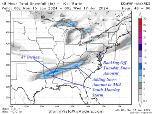
Fig. 2: The Sunday night through Tuesday snowfall amount forecast.
Also added to the forecast is a larger area of freezing rain with ice accretion Sunday night and Monday across East Texas and Louisiana (Fig. 3). In this zone, ice accretion of 1/10 inch is likely. Not enough to cause power outages but certainly a widespread hazardous travel issue emerges.
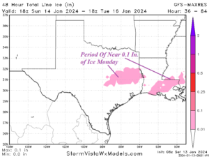
Fig. 3: The ice accretion amount forecast across East Texas and Louisiana for Monday.
Using the new National Blend of Models (NBM) model, daybreak temperatures on Tuesday are forecast to dip to near 30 at Corpus Christi and 27 in Houston with wind and wind chill in the teens (Fig. 4). Forecast values over Arkansas and Northern Louisiana could be colder than indicated due to fresh snow cover.
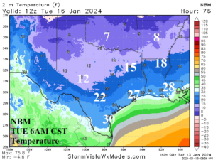
Fig. 4: The NBM temperature forecast for 6AM CST across ERCOT on Tuesday morning.
The coldest morning in the ERCOT region is Wednesday when Houston dips to 21 and Corpus Christi 26 (Fig. 5). The wind is easing Wednesday morning. However, the 1’s indicated across Arkansas could easily be near zero given snow cover. New Orleans drops to the low 20’s.
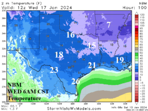
Fig. 5: The NBM temperature forecast for 6AM CST across ERCOT on Wednesday morning.
Mid-to-late next week moderates across ERCOT before another cold air mass arrives for the early weekend. By Saturday morning, temperatures drop to 30 (with wind) in Houston with 20’s a short distance from the Gulf Coast (Fig. 6).
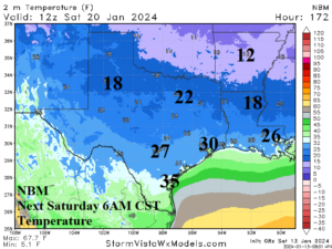
Fig. 6: The NBM temperature forecast for 6AM CST across ERCOT next Saturday morning.
U.S. heating demand peaks when cold weather strikes Chicago, New York City, and Atlanta simultaneously as forecast by NBM beginning next Wednesday morning (Fig. 7) and repeating into the weekend.
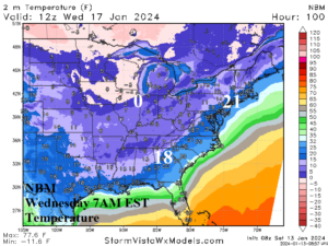
Fig. 7: The NBM temperature forecast for 6AM CST across the East U.S. on Wednesday morning.
After next week’s cold burst, U.S. heating demand eases. The U.S. gas population weight HDD forecast into early February begins a less cold adjustment from 24 hours ago (Fig. 8). The week of Jan. 19-25 is moderately cold and late month shifts warmer than normal.
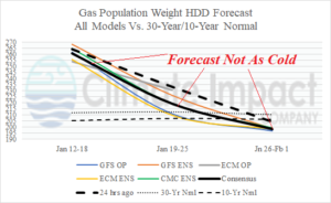
Fig. 8: The U.S. population weight HDD forecast utilizing all models, their consensus, and comparison with 24 hours ago and the 10-year/30-year normal.
