The Latest on U.S. Winter Storm “Gerri”
01/13/2024, 6:28 am ESTU.S. Cold Peak Was Monday January 15th Followed Closely by Saturday January 20th
01/16/2024, 3:57 pm EST
Fig. 1: NOAA/WPC synoptic forecast for 6PM CST on Sunday.
Discussion: In a change to the forecast, the arctic boundary in Texas is SLOWER to shift south today and tonight. The slower progress of this boundary allows a larger veil of precipitation to emerge across the Mid-south and Texas. Most of the Texas precipitation is in the form of freezing rain and ice while snow blankets Arkansas to Tennessee. By Sunday evening, a large area of freezing rain extends from central to northeast Texas (Fig. 1). A Winter Weather Advisory is issued for this event. A Winter Storm Warning is issued in Arkansas to northeast Texas for snow and sleet mixed or all snow.
By 6AM CST Monday, the area of freezing rain expands to Northern Louisiana and continues in Central Texas just to the northwest of the Houston metro area (Fig. 2). The heaviest snow shifts to Tennessee. The arctic boundary is struggling to push southward due to the easterly flow induced by the South Texas low pressure area. Freezing rain and attendant icing is likely most of Monday in East Texas, mostly away from the coast, and across the northern half of Louisiana.
By Tuesday morning, the arctic boundary has shifted to the Texas Coast to Central Louisiana. Most of the freezing rain has diminished by this time. Areas of low pressure across the Southeast U.S. induce a large area of rain from the northeast Gulf States to the Carolinas and snow for the Northeast U.S. Corridor including coastal locations (Fig. 3).
The latest ice accretion forecast using GFS (Fig. 4) indicates a large area of slight amount in Texas with larger amount in Louisiana where the precipitation is a combination of freezing rain and ice pellets (sleet). The ice accretion amount exceeds 0.1 in. in parts of eastern Texas and a large part of Louisiana. Usually, a ¼ inch ice accretion is needed to create power line disruption. However, this event occurs with stronger wind therefore increasing the risk of a power disruption in East Texas to Central/South-central Louisiana. The area of ice accretion is likely larger than the forecast model in Texas.
The GFS has a higher amount of snowfall for Arkansas to Tennessee including a 4-6 in. risk across Southeast Arkansas (Fig. 5).
As the storm moves off the East Coast Tuesday, a veil of moderate snow reaches the Coastal Northeast Corridor including 2-4 in. for Washington, DC to New York City and 4-8 in. across southeast Massachusetts (Fig. 6).
Nationally, a plethora of weather watch, warning, and advisories are issued (Fig. 7). Most notable is the increasing winter precipitation issues across Texas and the Mid-south States, ongoing lake-effect snows for the Great Lakes region, and a wide veil of wind chill warnings as an arctic air mass spreads across the Great Plains.
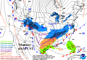
Fig. 2: NOAA/WPC synoptic forecast for 6AM CST on Monday.
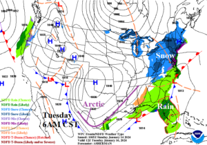
Fig. 3: NOAA/WPC synoptic forecast for 6PM CST on Monday.
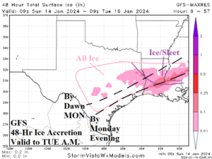
Fig. 4: The GFS 48-hour ice accretion forecast valid through early Tuesday morning.
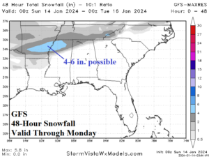
Fig. 5: The GFS 48-hour snowfall forecast valid through Monday.

Fig. 6: The ECM 24-hour snowfall forecast for the Northeast U.S. valid Tuesday.
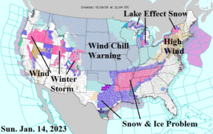
Fig. 7: Latest U.S. NOAA/NWS weather watch, warning, and advisories.