Freezing Rain/Icing A Larger Concern for Texas/Louisiana
01/14/2024, 7:06 am ESTSubsurface Equatorial Pacific Cooling Underway as El Nino 2023-24 Likely Moving Past Mature Stage Soon
01/17/2024, 8:03 pm ESTHighlight: Cold peak Monday January 15th followed closely by Saturday January 20th.

Fig. 1: Forecasts are trending colder for early this weekend as the U.S. gas weighted HDD projection for Saturday is close to Monday’s peak.
Discussion: The second burst of arctic air projected for late this week in the U.S. is trending colder. The U.S. gas weighted HDD forecast indicates a second peak for the January 2024 cold episode occurring on Saturday (Fig. 1). The second cold peak is just short of the amplitude of yesterday’s peak cold. The aerial coverage of the second peak is larger while not quite as cold as the first event in the Central U.S., there is a farther eastern reach with this second event as the East Coast is very cold (Fig. 2). Morning temperatures on Saturday indicate very cold weather with strong wind chill in Chicago, New York City, and Atlanta (Fig. 3). The extreme cold for each location at the same time is a catalyst for rising and sometimes spiking natural gas prices.
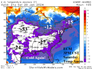
Fig. 2: The ECM departure from normal temperature on Saturday afternoon indicates a sprawling cold which includes the high energy demand region of the East Coast.

Fig. 3: The ECM projected morning low temperature across the East U.S. on Saturday indicates Chicago, New York City, and Atlanta are into the arctic air.