U.S. Cold Peak Was Monday January 15th Followed Closely by Saturday January 20th
01/16/2024, 3:57 pm ESTMJO Inspires Widening Western Desert Heat in Australia; Dangerous Tropical Systems Appear
01/18/2024, 8:45 am ESTExecutive summary: El Nino 2023-24 roars on but signs of weakening ahead have emerged. Cooling subsurface waters in the West Pacific have shifted east of the Dateline during January. Warm waters just beneath the surface of the equatorial Pacific to sustain El Nino remain, but the emerging cool waters are likely to expand and weaken/dissipate Pacific surface warming over the next several months. Expect neutral ENSO during Q2/2024 and La Nina by Q3/2024.
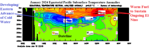
Fig. 1: January 2024 (so far) equatorial Pacific Ocean subsurface temperature anomalies.
Discussion: One of the leading diagnostics to determine a potential phase change of El Nino southern oscillation (ENSO) is identifying the trend of equatorial Pacific Ocean subsurface temperature anomalies. During January 2024 so far, a cool water zone at 50-300-meter depth in the West Pacific has extended eastward past the Dateline (Fig. 1). The cooler waters are undercutting the upper ocean anomalous heat fueling El Nino from the surface to 100 meters located just west of the Dateline and eastward northwest coast of South America. As the regime described has developed, the warm anomaly has spread westward while the cool anomaly is widening while spreading eastward. Over the next few months, the cool anomaly will continue to expand and gradually dissipate the upper ocean warmth which ends El Nino. Following that process, trade winds increase to up-well the increasingly cool subsurface by later Q2/2024 and La Nina development is underway.
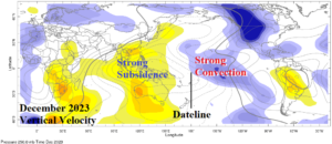
Fig. 2: The December 2023 vertical velocity anomalies became a classic El Nino signature across the global tropics/subtropics.
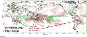
Fig. 3: The December 2023 precipitation anomalies identify dryness and drought concern for parts of South Africa, Indonesia, and Brazil.
In December 2023, the convection/subsidence pattern in the tropics finally shifted to a classic El Nino signature. Negative vertical velocities (-VV) identifying divergent columns of air in the upper atmosphere caused by rising currents creating convective clouds were located across the tropical East Pacific (Fig. 2). This location is where convection is common during El Nino episodes due to the anomalous warm ocean. To compensate for the rising air currents above the tropical East Pacific, a large area of positive vertical velocities (+VV) in response to atmospheric subsidence is present across the Maritime Continent, and parts of South America, and Africa. The subsidence areas are a concern as large areas of drought can develop. Note the dry December 2023 climate in South Africa, Indonesia, and Brazil (Fig. 3).
The cooling waters shifting eastward in the equatorial Pacific Ocean are a sign that El Nino is likely in the mature stage with weakening to begin shortly. A collection of all dynamic and statistical ENSO phase forecast models conveys weakening of El Nino is ahead for the next 2-4 months followed by neutral ENSO for mid-year and possibly La Nina by August (Fig. 4). Interestingly, the analogs are quicker to weaken El Nino while dynamic models are quicker to develop La Nina.
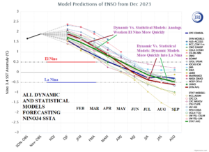
Fig. 4: The International Research Institute for Climate and Society collects all dynamic and statistical ENSO phase forecast models to project ENSO ahead.