Wet Climate in Panama May Wait Until Q4/2024
01/11/2024, 5:12 pm ESTThe Latest on U.S. Winter Storm “Gerri”
01/13/2024, 6:28 am EST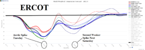
Fig. 1: ERCOT System temperature average utilizing all forecast models through the next 15 days. The arctic spike is Monday night and Tuesday, and the frigid weather occurs with wind. Fortunately, the cold spike is relatively brief.
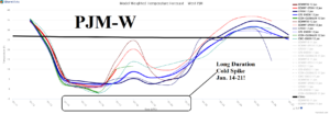
Fig. 2: PJM-West System temperature average utilizing all forecast models through the next 15 days. A long duration arctic chill settles in beginning Sunday.
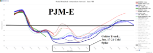
Fig. 3: PJM-East System temperature average utilizing all forecast models through the next 15 days. Trending colder for the East mid-next week into the following weekend.
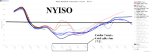
Fig. 4: NYISO System temperature average utilizing all forecast models through the next 15 days. Mid-to-late next week cold spike is indicated for the New York area.
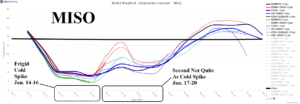
Fig. 5: MISO System temperature average utilizing all forecast models through the next 15 days. A long duration cold spell settles in across MISO beginning Sunday.
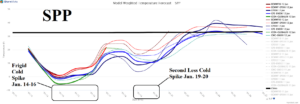
Fig. 6: SPP System temperature average utilizing all forecast models through the next 15 days. A frigid cold spike for SPP to start next week followed by a second less intense event.