
Massive U.S. Storm Developing, Widespread Hazards Central and East U.S. Ahead!
01/24/2026, 10:02 am EST
Oceanic La Nina Ends
01/26/2026, 3:54 pm EST
Climate Impact Company Early U.S. Notes
Issued: Sunday January 25, 2026
Highlight: Ice and snow wind down in Texas as frigid air mass arrives, ice storm shifts to Mid-Atlantic, heavy snow on the way for New York/New England.
| Location | # Days <32 | Location | #Days <32 | #Days <32 | |
| Dallas | 2 | Chicago | 10 | Washington | 9 |
| Midland | 2 | Memphis | 8 | Baltimore | 9 |
| Austin | 1 | Cleveland | 15+ | Philadelphia | 9 |
| Houston | 0 | Pittsburgh | 13 of 15 | New York | 11 of 15 |
| Little Rock | 6 of next 8 | Richmond | 7 of next 8 | Boston | 11 of 15 |
Table 1: Number of consecutive days, beginning today, when maximum temperature does not reach 32F from ALL MODELS 15-day forecasts.
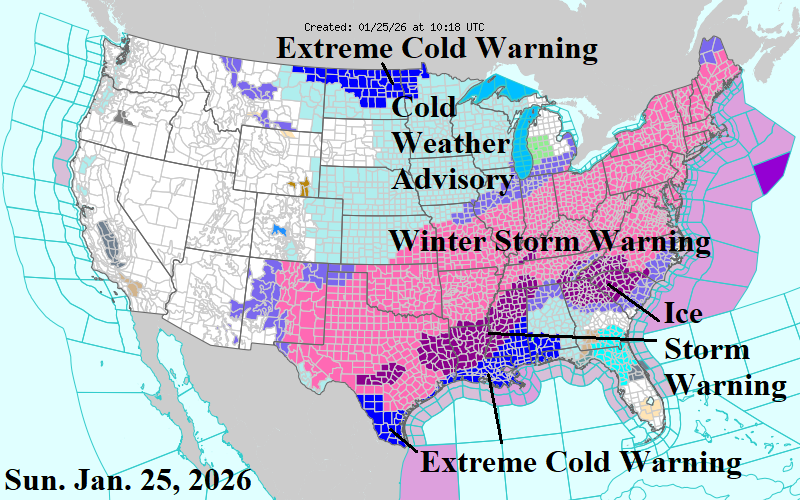
Fig. 1: Latest NOAA/NWS weather watch, warning, and advisories.
Discussion: The number of days, beginning today, when maximum temperature stays below 32F varies widely with latitude. A quick recovery is expected across ERCOT where Midland to Dallas will rise above 32F during the day by Tuesday (Table 1). However, further north, in Little Rock, daytime highs exceed 32F only twice through the next 8 days. Memphis observes 8 consecutive days below freezing and Chicago is <32F for 10 consecutive days. Cleveland is the coldest spot as the latest 15-day forecasts utilizing all models indicate below freezing each day. Pittsburgh is <32F 13 of the next 15 days. Washington/Baltimore/Philadelphia are <32F during the day for 9 consecutive days after the snowstorm. New York City and Boston are <32F during the day for 11 of the next 15 days.
Winter Storm Warning’s are in effect from Texas to the East Coast from North Carolina to Maine (Fig. 1). An Ice Storm Warning is maintained in South-central Texas, East Texas, Louisiana, and Mississippi plus Georgia and South Carolina. An Extreme Cold Warning is issued for the west/north Gulf Coast.
The latest NBM snowfall forecast indicates 18-24 inches of snow from Albany to Boston today and Monday (Fig. 2). 10-18 inches of snow extends from Ohio across Pennsylvania. Amounts are cut back Maryland and southward due to sleet and freezing rain. The core of major ice accretion stretches from Eastern Louisiana to Kentucky, the Southern Appalachians, and Raleigh to Richmond (Fig. 3).
The synoptic maps from NOAA/WPC identify current storm status with heavy snow extending from the Mid-south U.S. to the northern Mid-Atlantic States (Fig. 4). Freezing rain and icing covers much of Arkansas into Louisiana northeastward to the Tennessee Valley and the Carolinas through Virginia. Heavy rain and thunderstorms affect Southeast Louisiana. By this evening, heavy snow spread across New York and New England with freezing rain and icing in the Interior Mid-Atlantic as rain arrives on the Mid-Atlantic Coast (Fig. 5).
The following cold is impressive with <18F risk extending southward, almost to the Gulf Coast, and well into the Carolinas (Fig. 6). The <0F risk through the next 5 days extends southward to the southern Great Plains and eastward to near I-95 in the East (Fig. 7). The deep snow propels a long duration cold event across the eastern half of the U.S. as indicated by ECM (Fig. 8-9).
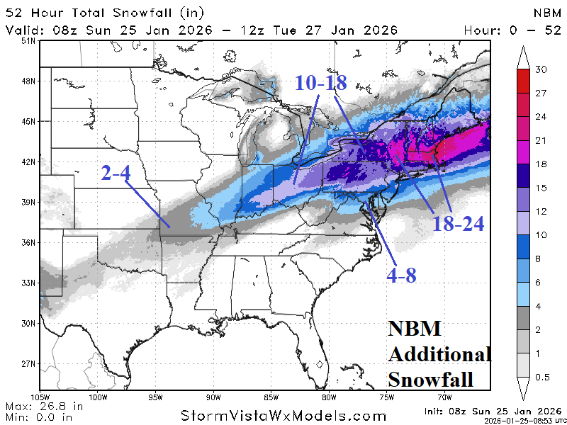
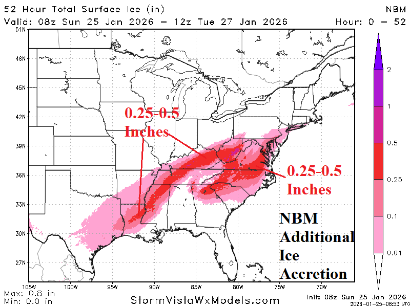
Fig. 2-3: The latest NBM snowfall and ice accretion forecast for the remainder of the East U.S. winter storm.

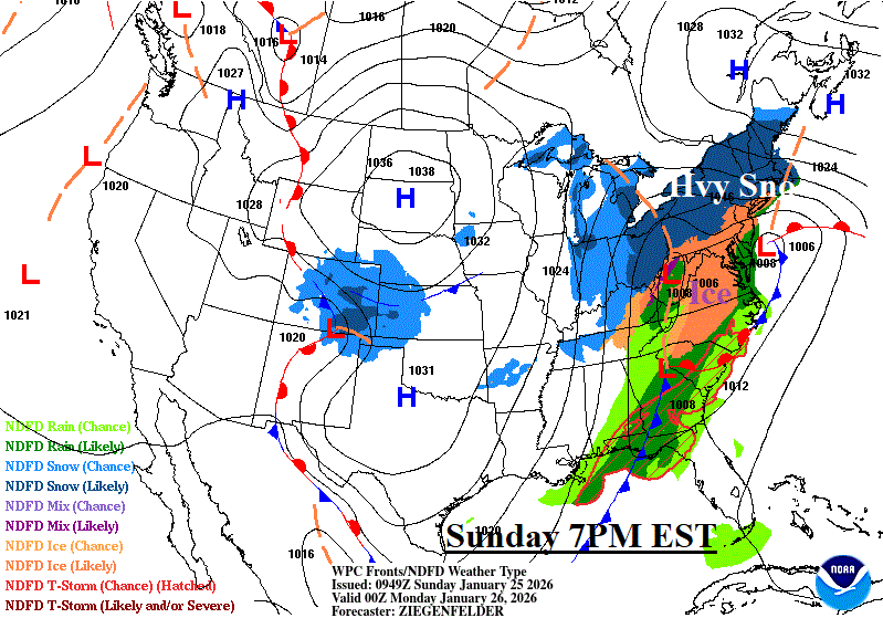
Fig. 4-5: NOAA/WPC weather maps for now and 7PM EST later today.
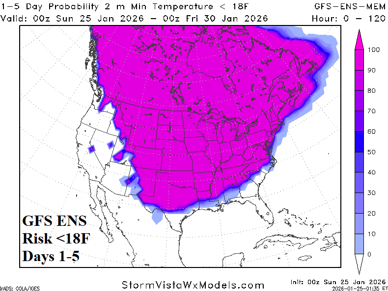
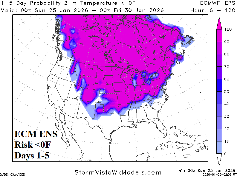
Fig. 6-7: GFS and ECM ENS risk of <18F and <0F over the next 5 days.


Fig. 8-9: ECM 14-day temperature anomaly forecast for the U.S.