Great Plains Dry Pattern Continues as Drought Worsens
10/10/2024, 4:45 am EDTSummer 2024-25 Focus on Evolving Drought Interior East Australia.
10/15/2024, 7:52 pm EDTExecutive summary: Climate diagnostics reveal marginal support for weak La Nina ahead. Dynamic and analog forecasts maintain weak La Nina for late 2024 likely not lasting long ending as meteorological winter 2024-25 in the northern hemisphere closes. The low confidence ENSO phase forecast for the remainder of 2025 is steady neutral ENSO phase. Strong ENSO events are not likely into 2026.
Discussion: The daily Nino34 SSTA observation is -0.56C within the La Nina threshold (-0.50C). Since Sep. 16, the Nino34 SSTA has averaged -0.50C (Fig. 1). Typically, 2-3 months of Nino34 SSTA cooler than -0.50C is required for a La Nina onset. The Madden Julian oscillation (MJO) is forecast to shift across Maritime Continent toward the Dateline during the next 2 weeks. The southern oscillation index (SOI) is weak positive and normally shifts to negative phase if MJO shifts east of the Dateline. The 15-day SOI forecast is for a steady positive phase. The Nino34 SSTA is walking the -0.50C La Nina threshold. Climate diagnostics are convincing that staying near that threshold and resisting an obvious La Nina transition is likely to continue.
The cooler waters east of the Dateline are likely to defeat a moderate intensity MJO eastern shift. If MJO moves east of the Dateline, the SOI turns negative, and up-welling trade winds ease causing ENSO phase to return to neutral. A return of the MJO to the Indian Ocean and the attendant +SOI regime to inspire La Nina development probably needs another 4 weeks or so to generate. Consequently, La Nina onset would not occur until Dec. 1st at the earliest.
The multivariate ENSO index (MEI) was -0.7 for late summer implying global climate shifted to weak La Nina. Unfortunately, the MEI for SEP-24 is not available (yet) to determine the trend. However, based on the Nino34 SSTA and SOI regime, the MEI value of -0.7 is likely unchanged.
Bottom line? Anticipated La Nina onset remains on the horizon and certainty of a weaker La Nina ahead increases.
The 2024 La Nina development is clumsy. Looking at subsurface equatorial Pacific Ocean upper ocean heat anomalies, the OCT-24 signature indicates moderate cool east of the Dateline with near normal ocean temperatures at the surface (Fig. 2). Comparing other La Nina episodes developing during October from the past 20 years (2020, 2016, 2010, and 2007) reveal the subsurface is generally much cooler than OCT-24 (Fig. 3-6). In fact, the cooler the subsurface, the stronger the La Nina event. The current subsurface upper ocean heat observations in the equatorial East Pacific suggest La Nina 2024-25 is weak.
The SOI tendency reveals a similar trend. The monthly SOI through SEP-24 is resisting the La Nina +0.5 SOI threshold (Fig. 7). The 2007 La Nina shifted to stronger +SOI in OCT/NOV while the other analog years were already firmly within the +SOI (La Nina) threshold. Once again, another sluggish diagnostic identifying the character of the current ENSO phase.
The consensus of all forecast models is La Nina onset during NOV/DEC 2024, peak La Nina intensity in DEC/JAN 2024-25 and dissipation by FEB/MAR 2025 (Fig. 8). The spread of all Nino34 forecasts is generous and trending away from La Nina. The Climate Impact Company Nino34 SSTA forecast indicates neutral ENSO for 2025 into early 2026 (Fig. 9). Previously, a double La Nina was indicated.
![]()
Fig. 1: Daily Nino SSTA region observations identify a steady trend toward the La Nina threshold during recent weeks.
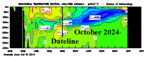
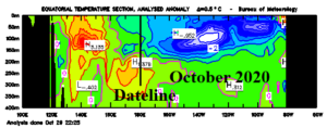
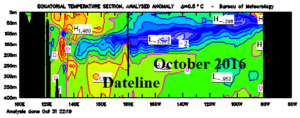
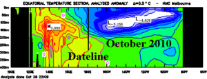
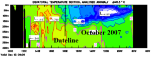
Fig. 2-6: The subsurface upper ocean heat is moderately impressive during OCT-24 so far and not as cool as previous developing La Nina episodes during OCT of 2020, 2016, 2010, and 2007.
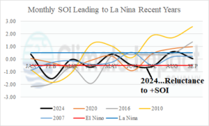
Fig. 7: The monthly SOI for 2024 and previous recent La Nina onset years reveals a reluctance to enter La Nina-like +SOI phase.
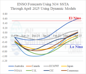
Fig. 8: All leading Nino34 SSTA forecasts using dynamic models plus the CIC analog forecast and consensus through APR-25.
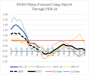
Fig. 9: The Climate Impact Company Nino34 SSTA analog forecast through FEB-26.