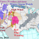
U.S. Weather Pattern Features Significant Increase in Hazards
02/16/2026, 12:02 pm EST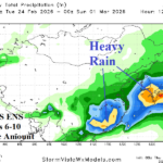
Heavy Rain Followed by Cold Outbreak in China Late FEB/Early MAR
02/19/2026, 9:19 am EST
Climate Impact Company Month 1-4 Outlook
Australia
Issued: Wednesday, February 18, 2026
Highlight: Rains are increasingly widespread to finish meteorological summer, continue in the East during March. Shift toward El Nino as winter arrives.
Executive Summary: The month 1-4 ahead climate forecast for Australia is updated. The heavy rain North/dry and hot climate South regime during summer 2026 is changing as rainfall becomes increasingly widespread to finish meteorological summer. The outlook for March maintains heavy rain risk across the North and East easing during April. The CIC-CA forecast indicates cooler-than-normal autumn after the intense (anomalous) heat of summer 2026. As winter approaches, El Nino onset is possible.
Climate discussion: The Southern Australia drought (Fig. 1) induced a feedback mechanism to the mid-troposphere igniting a hostile subtropical ridge pattern (Fig. 2) which, in large part, controlled the meteorological summer climate across Australia. Included are anomalous heat and dryness within the aerial coverage of the subtropical high pressure and prohibitive wet monsoon rains across Northern Australia (Fig. 3-4). During the period, La Nina climate dominated while Indian Ocean Dipole shifted neutral.
The Global SSTA forecast utilizing the International Multi-model Ensemble (IMME) governing the Australia month 1-4 outlook and valid for APR/MAY/JUN 2026 indicates
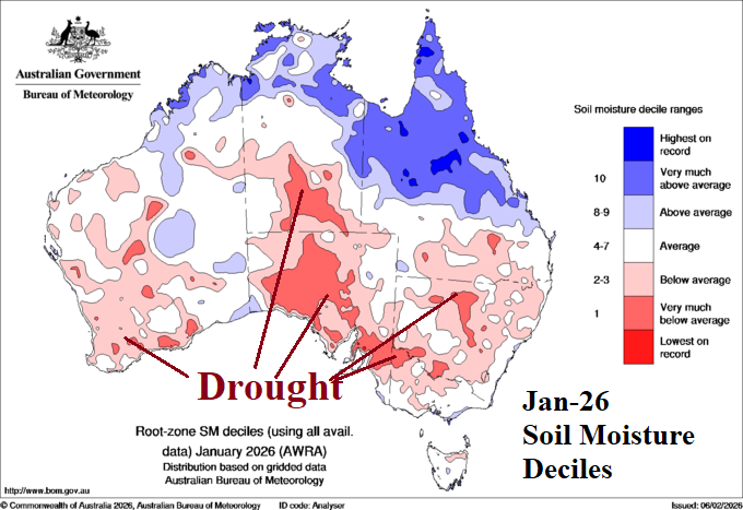
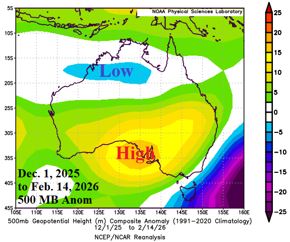
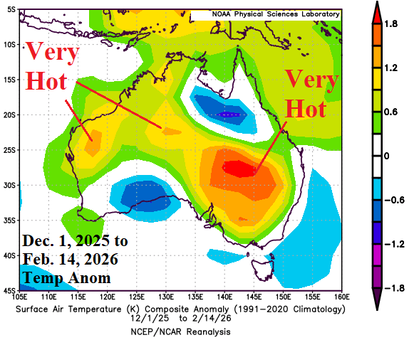
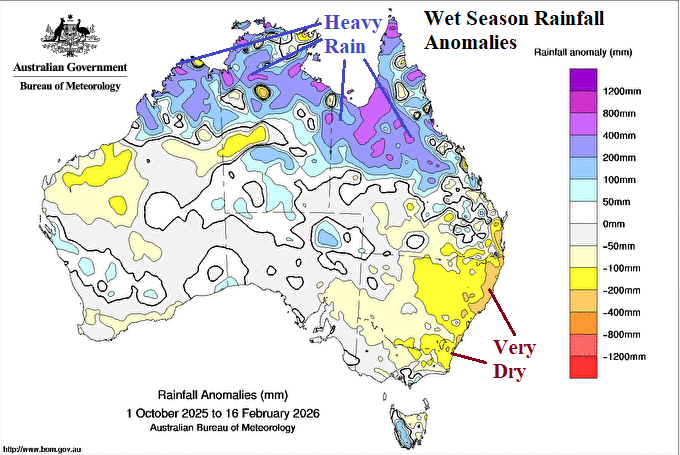
Fig. 1-4: The JAN-26 soil moisture deciles across Australia, summer so far 500 MB height and temperature anomalies, plus the wet season rainfall anomalies.
The Global SSTA forecast utilizing the International Multi-model Ensemble (IMME) governing the Australia month 1-4 outlook and valid for APR/MAY/JUN 2026 indicates the beginnings of El Nino and a possible positive IOD regime with ongoing marine heatwaves southwest and east-southeast of Australia (Fig. 5). Potential for a faster El Nino and +IOD evolution is possible. By midyear, both El Nino and +IOD are expected although confidence is below average.
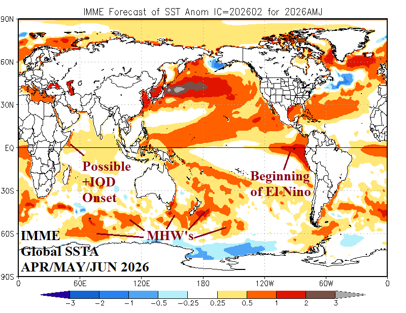
Fig. 5: The Climate Impact Company constructed analog temperature and precipitation anomaly forecast for January 2026.
March 2026: After a dry summer, wet weather spread across much of Australia after mid-February and consolidates in the East in March. Anomalous heat continues across the drought area across Southern Australia.
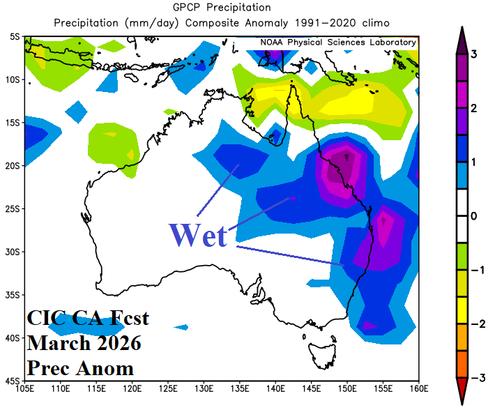
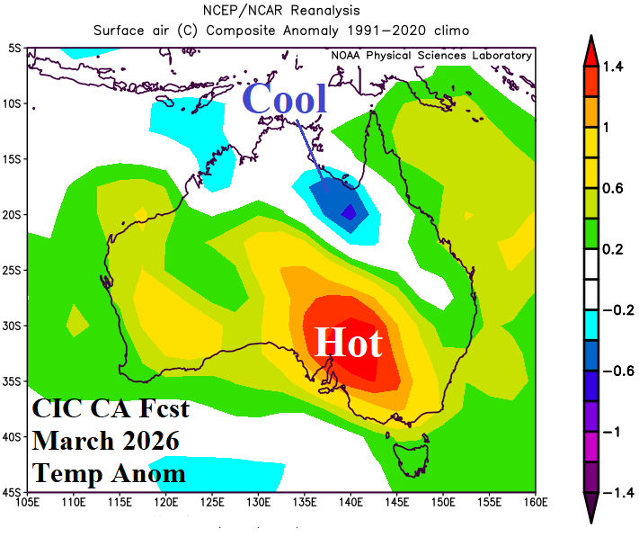
Fig. 6-7: The Climate Impact Company constructed analog temperature and precipitation anomaly forecast for March 2026.
April 2026: A semi-permanent upper trough cools Australia during April. The wet weather pattern is pushed to the North Coast and lingers on the New South Wales Coast.
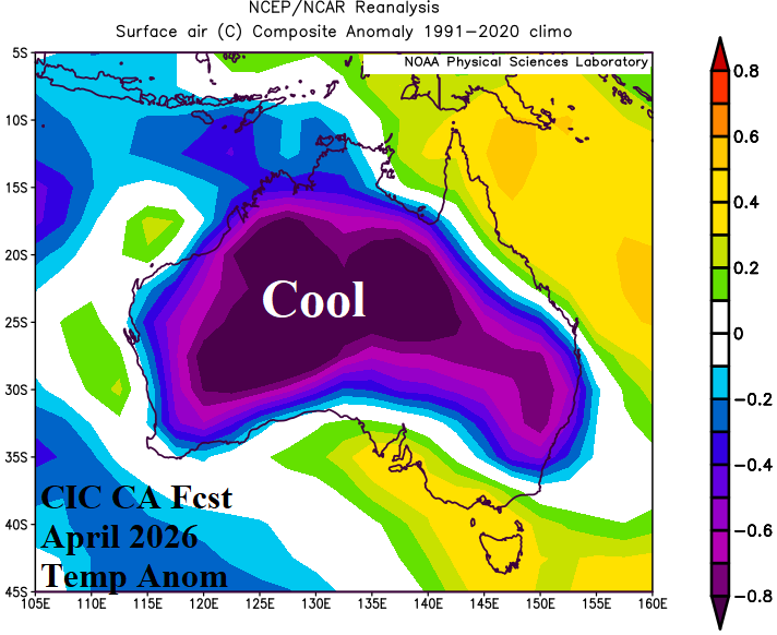
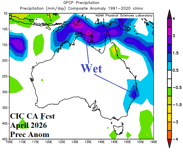
Fig. 8-9: The Climate Impact Company constructed analog temperature and precipitation anomaly forecast for April 2026.
May 2026: Cooler than normal climate lingers into late autumn season for much of the continent. Drier than normal weather is forecast for the West Coast and parts of south and east coastal continent. Potentially, El Nino is on the horizon.
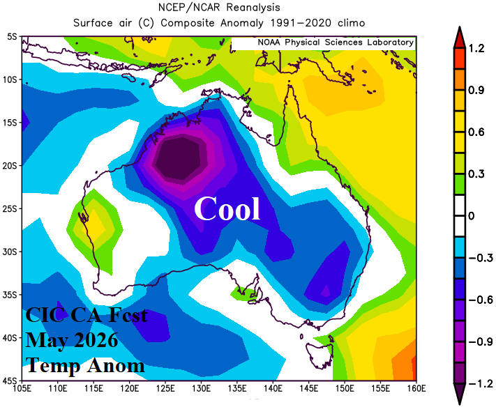
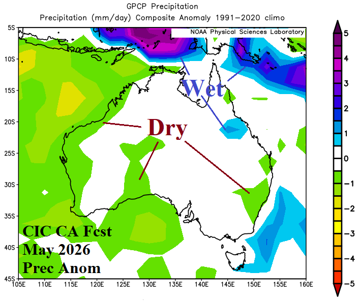
Fig. 10-11: The Climate Impact Company constructed analog temperature and precipitation anomaly forecast for May 2026.
June 2026: El Nino onset is possible in June. The early winter outlook is warmer than normal across Central and East Australia. Australia Bureau of Meteorology forecasts cooler than normal weather for the Southeast. The outlook is mostly drier than normal for each coastal region.
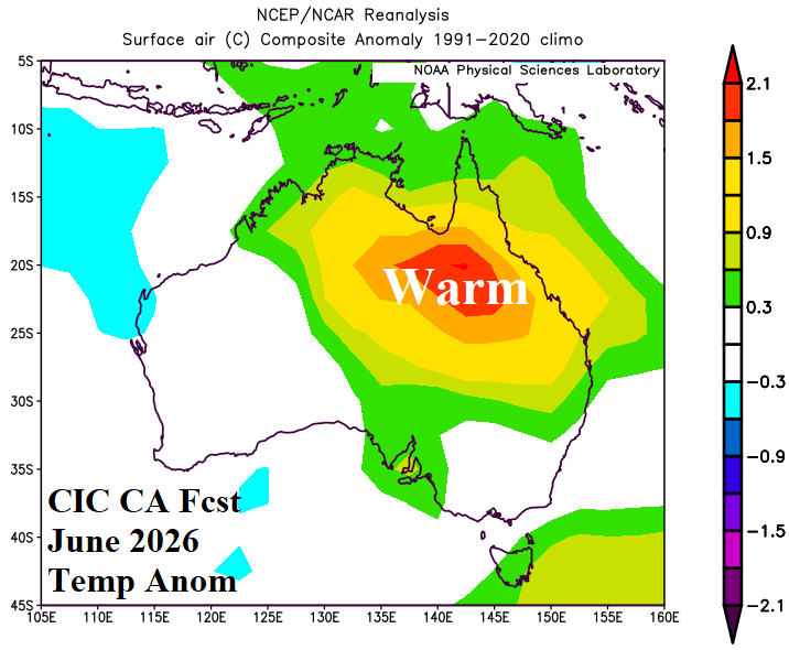
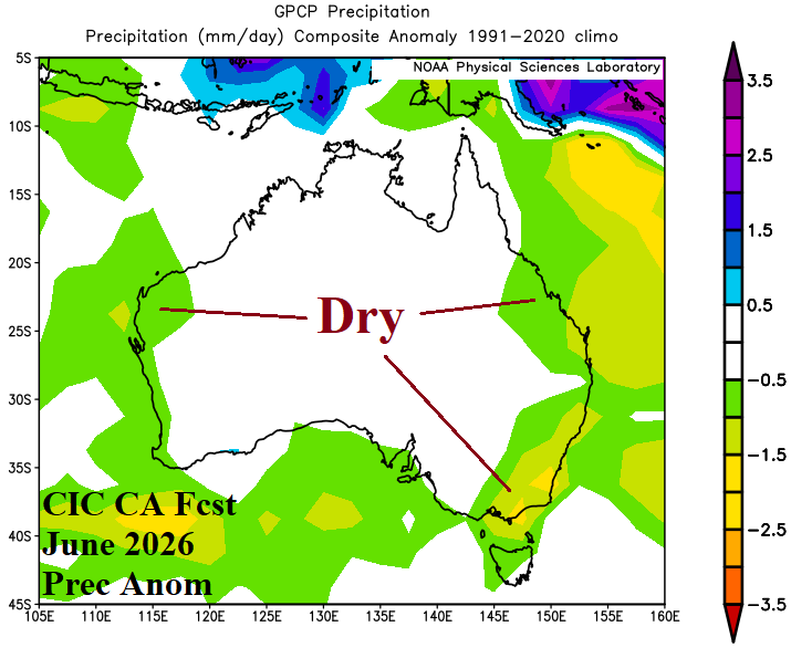
Fig. 12-13: The Climate Impact Company constructed analog temperature and precipitation anomaly forecast for June 2026.