Catastrophic Category-5 Major Hurricane Milton Heading for Tampa Area Making Landfall Tonight
10/09/2024, 5:51 am EDTWeak La Nina Ahead Won’t Last Long
10/14/2024, 4:33 am EDTDiscussion: Plethora of point forecasts in Florida for Hurricane Milton are concluding. Returning to normal schedule today. New week 2-4 forecasts for all regions are issued later today. Winter outlooks issued for EU/RU and China yesterday. Next climate projects are the ENSO forecast and Australia climate outlooks.
We begin with the U.S. AG Belt which remains arid and most vividly displayed by the 14-day percent of normal rainfall analysis (Fig. 1). The daily soil moisture anomaly analysis reveals the strengthening Great Plains drought (Fig. 2). All models remain very dry in the overnight 15-day outlooks. The exception is GFS which introduces some rain in the Upper Midwest in the 6-10-day forecast and a streak of rain in the southern Great Plains in the 11-15-day period (Fig. 3). Otherwise, the parched precipitation pattern continues. The CFS V2 16-30-day outlook maintains the mostly dry pattern (Fig. 4).
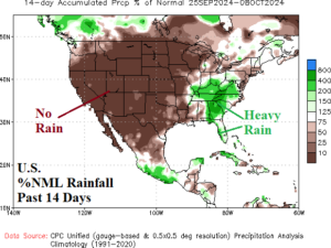
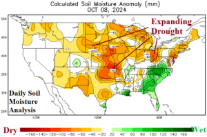
Fig. 1-2: U.S. 14-day percent of normal rainfall observations and the attendant daily soil moisture anomalies.
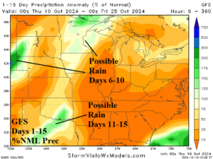
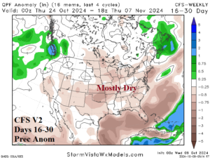
Fig. 3-4: The GFS 15-day percent of normal rainfall forecast across the U.S. AG Belt and 16-30-day outlook for precipitation anomalies across the U.S. by CFS V2.
In South America, the rainfall so far in October is minimal in Brazil and central/east portions of Argentina while beginning to pile-up over Northwest Argentina (Fig. 5). The GFS is utilized in the 15-day outlook. The model continues to indicate hefty rainfall across Central Argentina, and much of southern and southeastern Brazil although Central Brazil is dry (Fig. 6). GFS produces near equal rainfall amount in each of the 5-day periods through 15 days in both Argentina and Brazil. Recent GFS rainfall forecast verification is reasonable while ECM is much too wet.
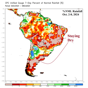
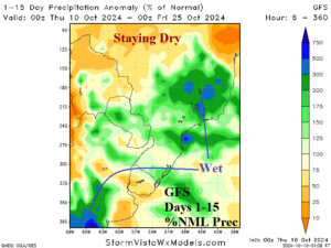
Fig. 5-6: South America 7-day rainfall anomaly analysis and 15-day GFS rainfall forecast.
The October 1-7 rainfall amount observations across Australia reveal moderate amount on the Southwest Coast and in Victoria (Fig. 7). The 15-day outlook using the Artificial Intelligence Forecast System (AIFS) reveals hefty rains on the East/Southeast Coast (Fig. 8). Most of the rain is in the medium range is vigorous upper troughs align east of Australia (days 6-10) and south of the continent (days 11-15).
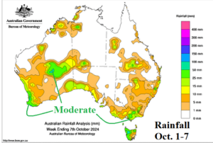
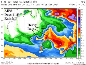
Fig. 7-8: Oct. 1-7 rainfall amount observations across Australia and the AIFS 15-day rainfall amount outlook.