Status of the Potential North America January 2025 “Polar Vortex” Forecast
12/10/2024, 4:21 pm ESTDespite Developing La Nina, Eastern Australia Is Dry/Hot Late-DEC to Mid-JAN
12/17/2024, 4:06 am ESTDiscussion: A strong positive phase Asia-Bering Sea-North America (+ABNA) index emerges over the next 2 weeks (Fig. 1) as a forceful deep Aleutian low pressure system forms and expands across most of the North Pacific (Fig. 2). The pattern is driven in-part due to a rush of cold wind off the Northeast Eurasia snow cover into the North Pacific across relatively warm water. The super low-pressure area and attendant cold surface wind up-well cool subsurface waters to cool off the North/Northeast Pacific SSTA pattern. The attendant surface wind follows the North Pacific gyre to the North America West Coast and turns south and southwestward accelerating cool SST into the deep tropics south and southwest of Hawaii via the California Ocean Current helping to strengthen La Nina (Fig. 3). The daily Nino34 SSTA has cooled to -0.70C and coupled with persistent positive phase southern oscillation index (+SOI) and the +ABNA forcing, NOAA should announce La Nina onset by early January. The effect of +ABNA on North America weather is mild (Pacific) maritime influence. Although eastern North America is cold in the 6-10-day period, the overall North America temperature pattern is quite warm for the remainder of December (Fig. 4). Additionally, the Aleutian Low propels a 200-225 mph mid-latitude jet stream eventually causing waves of heavy precipitation to strike the West Coast of North America (Fig. 5).
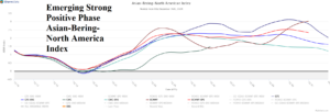
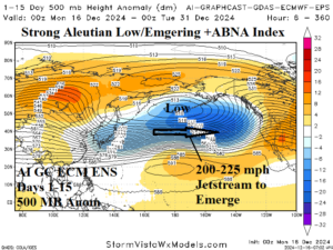
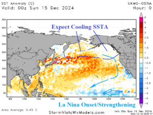
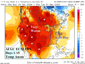
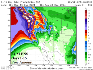
Fig. 1-5: A strong positive phase Asia-Bering Sea-North America (ABNA) index emerges over the next 15 days causing a deep Aleutian low pressure center that eventually cools the North and Northeast Pacific SSTA pattern. The influence on North America weather is warm with storminess into the West Coast.
