Brazil Forecasts Have Been Too Wet
11/03/2024, 11:10 am ESTNOAA/NHC: Rafael Likely to Avoid U.S. Coast
11/07/2024, 8:43 am EST
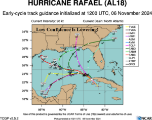
Fig. 1: Tropical cyclone tracks forecasts for Hurricane Rafael.
Discussion: Why are the forecast tracks for Hurricane Rafael so divergent for late this week and the weekend? The forecast (track) trend is westward as forecast models are increasingly siding with expansion of the Florida subtropical ridge westward this weekend. The westward expansion of the ridge prevents southwest flow ahead of a Central U.S. trough from reaching Rafael and the storm continues a westward drift. In fact, if the ridge extends far enough to the west, the steering current south of the ridge may guide Rafael into the Southwest Gulf early next week across warmer waters causing re-intensification to a major hurricane.
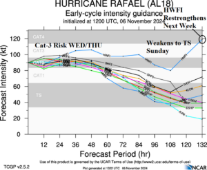
Tropical cyclone models indicate Rafael has a chance to become the season’s 5th major hurricane anytime within the next 1-2 days. The storm weakens slightly, turning westward, mainly due to slightly cooler waters late this week. Tropical cyclone models weaken Rafael to a tropical storm in 96 hours while offshore. This weakening forecast may be premature.
Tropical cyclone models maintain tropical storm strength of Rafael in 5 days because the storm is still offshore. In fact, HWFI intensifies the storm into a category-4 major hurricane early next week over the warm waters of the Southwest Gulf.
In summary, Rafael is becoming a dangerous storm approaching Western Cuba today and into the Southeast Gulf tonight. A major hurricane is possible. Once Rafael crosses the LOOP Current in the east-central Gulf the storm likely loses the ability to intensify and turns westward. After that point, the forecast is uncertain. The likelihood of a north turn into Louisiana is lower (from 65% yesterday to 45% today) and a more westerly track for the weekend is more likely (35% yesterday and 45% today.

Fig. 2: Tropical cyclone models and their intensity forecasts for Hurricane Rafael.
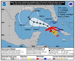
At 8AM EST, Hurricane Rafael was located at 21.0N/81.6W or about 160 miles south-southeast of Havana, Cuba. Rafael is moving northwest at 14 mph. Top wind is near 100 mph. Surface pressure has dropped to 964 MB. HWRF indicates Rafael has a chance at category-3 major hurricane status in the short-term. HWRF turns Rafael westward, to the south of the NOAA/NHC track, late this week when the storm is more certain to gain category-3 major hurricane intensity. The “caveat” forecast to the NOAA/NHC 5-day outlook is farther south and stronger once into the central Gulf of Mexico. If so, the storm may shift southwestward early next week.

Fig. 3: The NOAA/NHC 5-day forecast track for Hurricane Rafael.
