North Atlantic Tropics Become Favorable for Tropical Cyclone Generation
09/19/2024, 10:19 am EDTNino34 SSTA Reaches La Nina Threshold
09/23/2024, 1:51 pm EDTDiscussion: An eastward shift of the convection phase of the Madden Julian oscillation (MJO) is forecast by all operational models (Fig. 1). The MJO was semi-permanent in the tropical Indian Ocean to Maritime Continent since early August. The eastern shift is across the tropical East Pacific and Atlantic to West Africa through the next 2-3 weeks activating tropical cyclone activity in each ocean basin. Apparently, the MJO shift is potentially creating a significant influence on global climate. The 2-week global atmospheric angular momentum (GLAAM) forecast indicates potential for the strongest negative phase since earlier this year (Fig. 2). Normally, -GLAAM is associated with a relative slow down of mid-latitude jet stream wind and increased susceptibility of buckling upper-level westerly wind flow increasing the risk of significant storms. Implied is entrainment of tropical systems into the mid-latitude westerlies will produce major storms. The 2-week global wind oscillation (GWO) forecast projects a sharp phase_1/phase_2 character which indicates large transport of energy out of the tropics and northward of the subtropical latitudes (Fig. 3). These climate diagnostics forecasts suggest potential for powerful storms turning northward during the next couple of weeks including the North Atlantic basin.
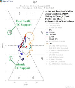
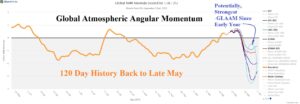
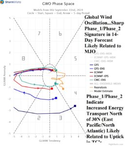
Fig. 1-3: The 2-week forecast of the Madden Julian oscillation (MJO), global atmospheric angular momentum (GLAAM), and global wind oscillation (GWO).