Warm Northeast Pacific Enhances “Atmospheric River”
12/19/2025, 8:36 am EST
Northern Hemisphere Climate Drivers Early January
12/26/2025, 8:13 am EST
Climate Impact Company Weekly ENSO Climate Diagnostics
Issued: Tuesday December 23, 2025, Happy Holidays!
Highlight: La Nina gains strength. Strongest signature of late 2025 so far.
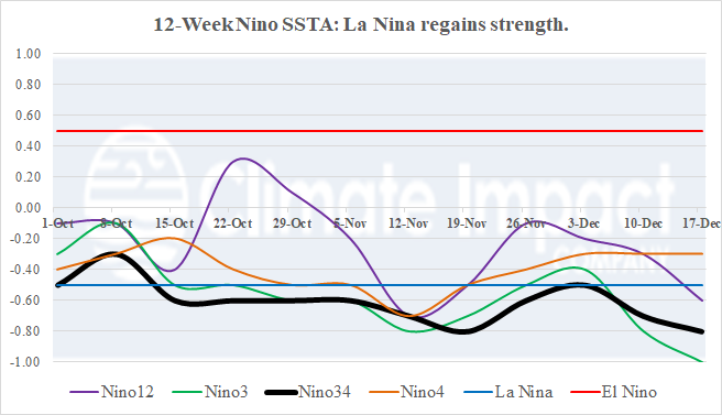
Fig. 1: The 12-week monitoring of the Nino SSTA regions and subsurface temperature anomaly schemes across the equatorial Pacific Ocean.
Discussion: La Nina has gained strength during December in the wake of a powerful convection phase of the Madden Julian oscillation (MJO) observed during November. The Nino3 SSTA is the coolest (of this episode) so far at -1.0C (Fig. 1). The Nino34 SSTA cools to -0.8C. In the subsurface, the eastern equatorial Pacific Ocean is plenty cool to sustain La Nina (Fig. 2). A warm Kelvin Wave shifting east near the Deadline appears to undercut the cool anomaly keeping cooler waters near the surface for trade winds to up-well to the surface. The southern oscillation index (SOI) has shifted to positive phase, indicating trade winds are increasing. The late 2025 La Nina appears fortified to continue through January. Forecast models indicate weakening later in Q1/2026.
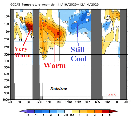
Fig. 2: Equatorial oceans sub-surface temperature anomalies.