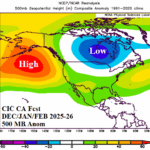
Climate Impact Company Winter 2025-26 Outlook Adjusted Colder, Especially East in January
11/07/2025, 4:30 am EST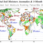
November 2025 Global Soil Moisture Outlook: Southern U.S. drought to evolve, Brazil dryness shifts into Argentina.
11/12/2025, 3:43 pm EST
Climate Impact Company Week 2-5 Outlook
North America
Issued: Tuesday, November 11, 2025
Highlight: Looking colder for December.
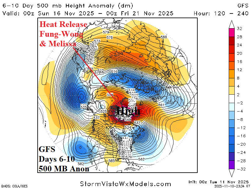
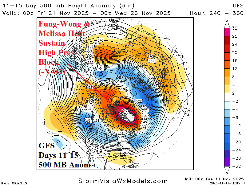
Chart of the day: How Fung-Wong (with some help from Melissa) cool the U.S. pattern for late November and December.
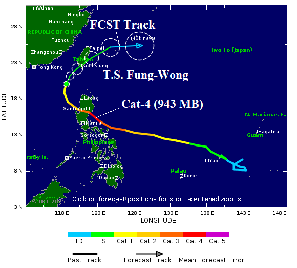

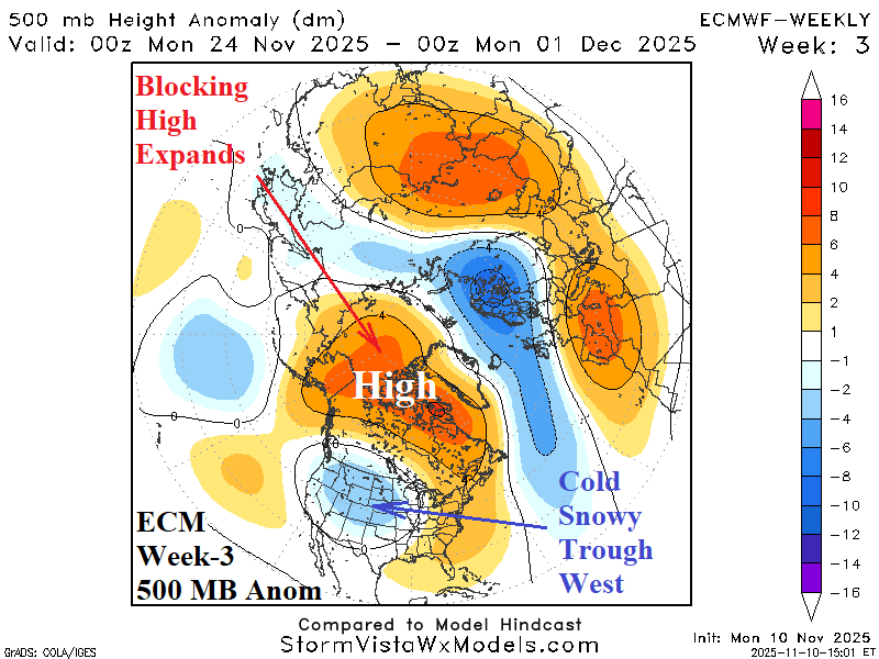
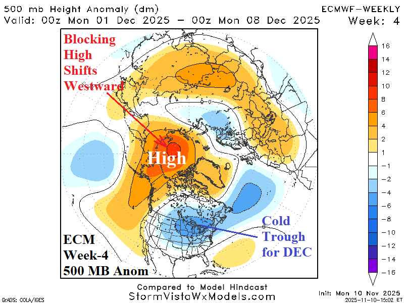
Discussion: Typhoon Fung-Wong peak intensity was 943 MB supporting a category-4 typhoon east of the Philippines. Does heat release from weakening Fung-Wong influence the polar climate mid-to-late November? Partially, but with significant help from warming over Greenland already in-place due to effects from Category-5 Major Hurricane Melissa (892 MB). The latest Fung-Wong forecast indicates weakening to tropical storm, now, and turning northeast and east with additional weakening mid-to-late week. The (GFS) 1-5-day 500 MB anomaly forecast identifies the intense trough absorbing Fung-Wong northeast of Japan and the latent heat release poleward to cause the Greenland high pressure block to expand into the polar region. In the 6-10-day period, polar high pressure intensifies and is maintained in the 11-15-day period according to GFS. The ECM “weeklies” tilt the high latitude high pressure westward in the week 3-4 outlook. To compensate for the high latitude westward shifting high pressure, a cold low-pressure trough develops in early December in the Midwest U.S. and is forecast to remain in that position for much of December according to ECM, CFS V2, and AI models as indicated in today’s week 2-5 outlook for North America.


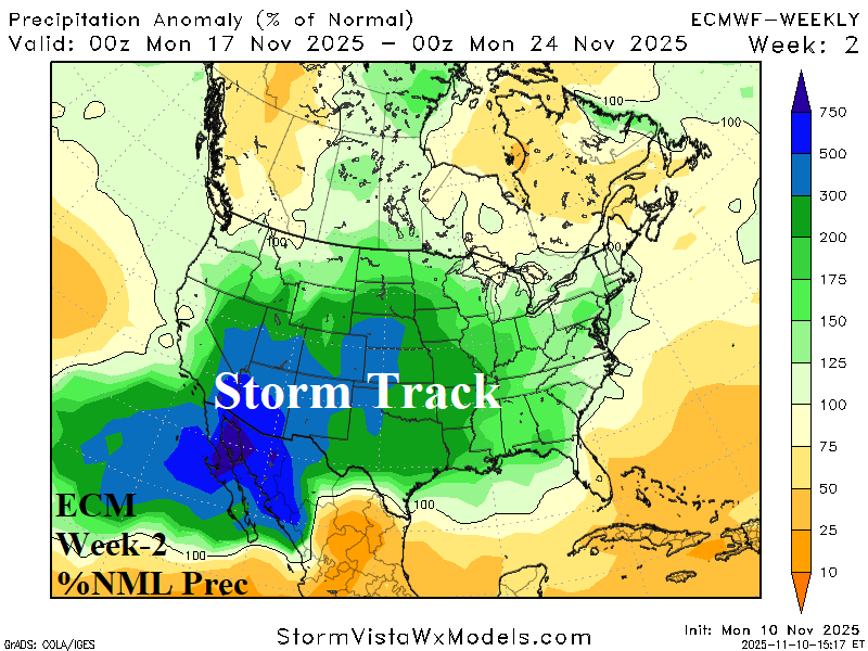
Week-2 Ahead Forecast valid November 16-23, 2025: Emerging vigorous storm track.
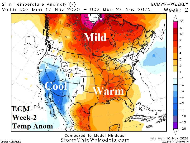

Discussion: An energetic “atmospheric river” is maintained by ECM which releases warmth east of Divide to keep the Gulf States warm and maintain mild climate in Canada while the Southwest is cool-to-cold.
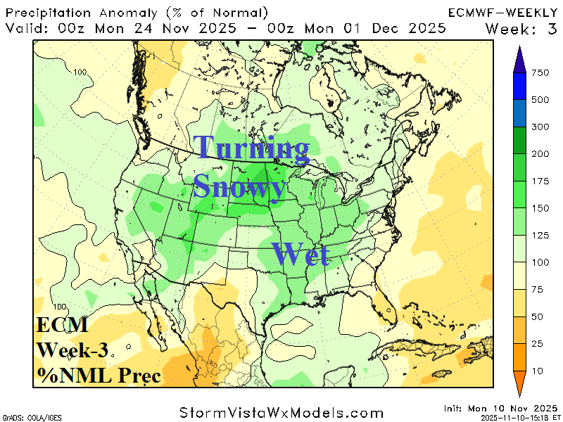
Week-3 Ahead Forecast valid November 23-30, 2025: Widening snow cover begins to chill the pattern late November.


Discussion: The storm track shifts east, strongest North-central/East-central U.S. The Interior West and North-central U.S. gain significant snow cover. Early period in Canada and the East U.S. is warm but colder changes emerge late period.
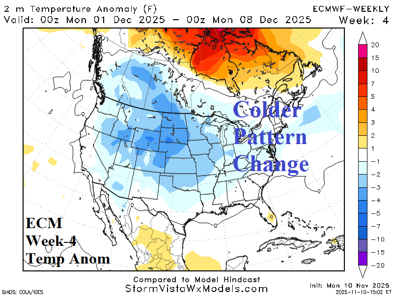
Week-4 Ahead Forecast valid November 30-December 7, 2025: Colder pattern change.


Discussion: By early December, the high latitude high pressure blocking pattern is positioned to trigger a cold upper trough over the Central U.S. with snow cover helping the colder pattern change to emerge.
Week-5 Ahead Forecast valid December 7-14, 2025: December looks cold northern half of U.S.
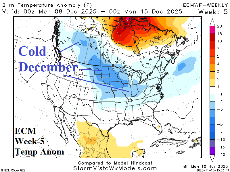

Discussion: The upper trough rests over deep snow cover across the Northern U.S. sustaining the chill into mid-December (and beyond) most-focused on the northern half of the U.S.

Climate Impact Company Week 2-5 Outlook
North America
Issued: Tuesday, November 11, 2025
Highlight: Looking colder for December.
Chart of the day: How Fung-Wong (with some help from Melissa) cool the U.S. pattern for late November and December.


Discussion: Typhoon Fung-Wong peak intensity was 943 MB supporting a category-4 typhoon east of the Philippines. Does heat release from weakening Fung-Wong influence the polar climate mid-to-late November? Partially, but with significant help from warming over Greenland already in-place due to effects from Category-5 Major Hurricane Melissa (892 MB). The latest Fung-Wong forecast indicates weakening to tropical storm, now, and turning northeast and east with additional weakening mid-to-late week. The (GFS) 1-5-day 500 MB anomaly forecast identifies the intense trough absorbing Fung-Wong northeast of Japan and the latent heat release poleward to cause the Greenland high pressure block to expand into the polar region. In the 6-10-day period, polar high pressure intensifies and is maintained in the 11-15-day period according to GFS. The ECM “weeklies” tilt the high latitude high pressure westward in the week 3-4 outlook. To compensate for the high latitude westward shifting high pressure, a cold low-pressure trough develops in early December in the Midwest U.S. and is forecast to remain in that position for much of December according to ECM, CFS V2, and AI models as indicated in today’s week 2-5 outlook for North America.


Week-2 Ahead Forecast valid November 16-23, 2025: Emerging vigorous storm track.

Discussion: An energetic “atmospheric river” is maintained by ECM which releases warmth east of Divide to keep the Gulf States warm and maintain mild climate in Canada while the Southwest is cool-to-cold.
Week-3 Ahead Forecast valid November 23-30, 2025: Widening snow cover begins to chill the pattern late November.

Discussion: The storm track shifts east, strongest North-central/East-central U.S. The Interior West and North-central U.S. gain significant snow cover. Early period in Canada and the East U.S. is warm but colder changes emerge late period.
Week-4 Ahead Forecast valid November 30-December 7, 2025: Colder pattern change.

Discussion: By early December, the high latitude high pressure blocking pattern is positioned to trigger a cold upper trough over the Central U.S. with snow cover helping the colder pattern change to emerge.
Week-5 Ahead Forecast valid December 7-14, 2025: December looks cold northern half of U.S.


Discussion: The upper trough rests over deep snow cover across the Northern U.S. sustaining the chill into mid-December (and beyond) most-focused on the northern half of the U.S.