Hurricane Model Peak Intensity Forecasts into Category-4 Major Hurricane Level for Helene
09/26/2024, 8:35 am EDTWatching The Gulf of Mexico for Additional TC Risk
09/29/2024, 2:45 pm EDTCharts of the day: Week 5-6 composite.
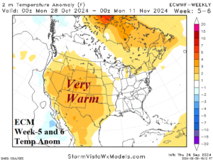
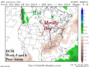
Discussion: The first third of November is very warm in the Great Basin and Southwest U.S. with attendant dryness. Dryness is most profound across the South and East U.S.
Week-2 Ahead Forecast valid October 6-12, 2024: Nationally very warm and dry.
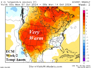
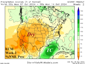
Discussion: Amplified upper ridge is projected across the Southwest to Central U.S. supporting a very warm to hot western half of the U.S. forecast. The only wet regime is in the Gulf of Mexico where another tropical cyclone is brewing.
Week-3 Ahead Forecast valid October 13-19, 2024: Staying dry and mostly warm.
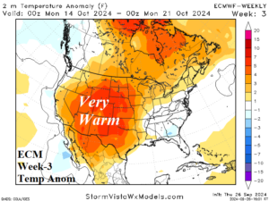
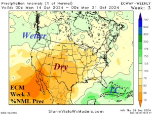
Discussion: In mid-October the upper ridge continues budging slightly to the east across the western Great Plains. Nationally, the pattern remains very dry, and the warm bias affects all the U.S. except Northwest and Southeast U.S.
Week-4 Ahead Forecast valid October 20-26, 2024: Staying dry and warm.
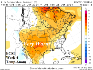
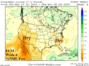
Discussion: The late October forecast projects a ridge across much of the U.S. keeping the national pattern warmer than normal, possible warmer than indicated. No significant rainfall is indicated.