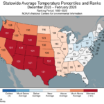
Winter 2025-26 State Temperature/Precipitation Rankings. Record Warm West/South; Scarry Dry Mid-south U.S.
03/11/2026, 9:51 am EDT
![]()
Climate Impact Company Sunday Report
Issued: Sunday, March 15, 2026
Highlight: East-central to East severe weather including tornadoes today and tomorrow; Upper Midwest blizzard, widespread following cold.
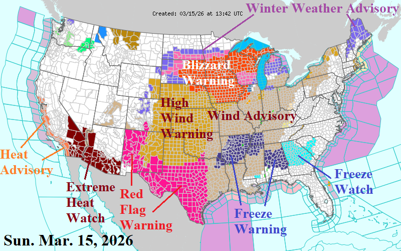
Fig. 1: NOAA/NWS weather watch, warning, and advisory areas.
Discussion: Plethora of hazardous weather across the U.S. to start the new week. Included is a Blizzard Warning for the Upper Midwest, High Wind Warning for the western and central Great Plains, and Extreme Heat Watch for the Southwest U.S. (Fig. 1). Late season cold risk for tomorrow extends across the Mid-south U.S. Major severe weather outbreaks are forecast for today and tomorrow across the eastern third of the U.S. Today’s outbreak includes the East-central and Southeast U.S. (Fig. 2). Tornado risk is widespread and most focused on the Central Mississippi River Valley. On Monday, the severe weather event regenerates on the U.S. East Coast and features widespread high wind damage risk including tornado threat from South Carolina to Pennsylvania (Fig. 3). Additionally, heavy rain causes flood risk from Maryland to southern New England tomorrow.
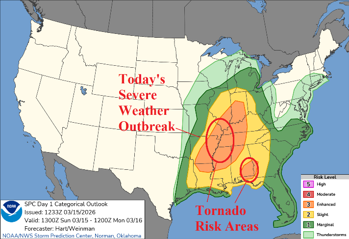
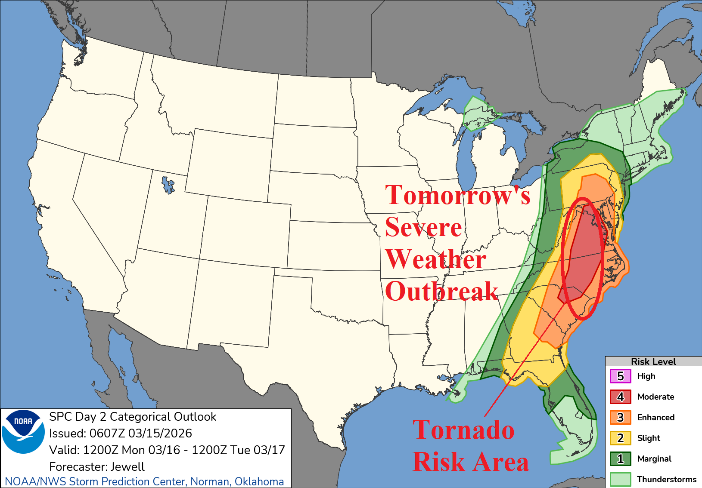
Fig. 2-3: NOAA/SPC severe weather outlook for today and tomorrow.
The 48-hour snowfall forecast across the Upper Midwest U.S. is impressive featuring widespread 10-30 inches of snow, most occurring with high wind, and near zero visibility (Fig. 4). The following cold causes morning low temperatures to plummet to -6F in Minneapolis, low teens in Chicago, and 30F in Atlanta Tuesday morning with significant wind chill (Fig. 5). The cold morning low temperatures sweep across the Northeast/East U.S. Wednesday morning (Fig. 6).
The latest U.S. gas population weight HDD forecast indicates near normal late season heating demand for the current week, below normal demand next week, and a return to near normal for late MAR/early APR (Fig. 7). The winter of 2025-26 temperature regime is continuing with a strong warm bias across the Southwest U.S. sometimes extending eastward and a cold trajectory from Canada into the Northeast U.S. The 6-10-day forecast is briefly warmer into the East followed by returning chill in the 11-15-day outlook causing the increase in late month HDD.
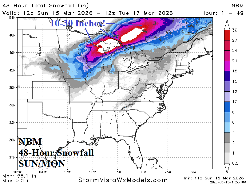
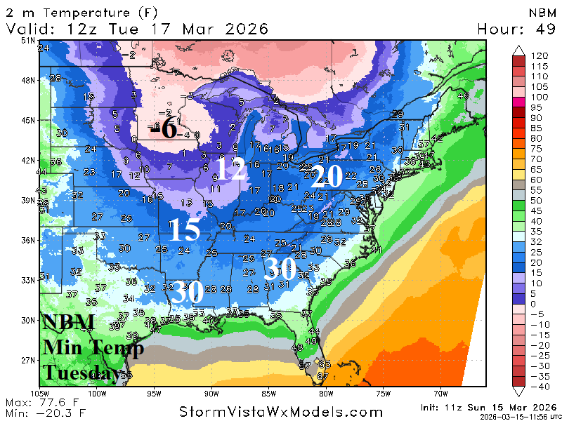
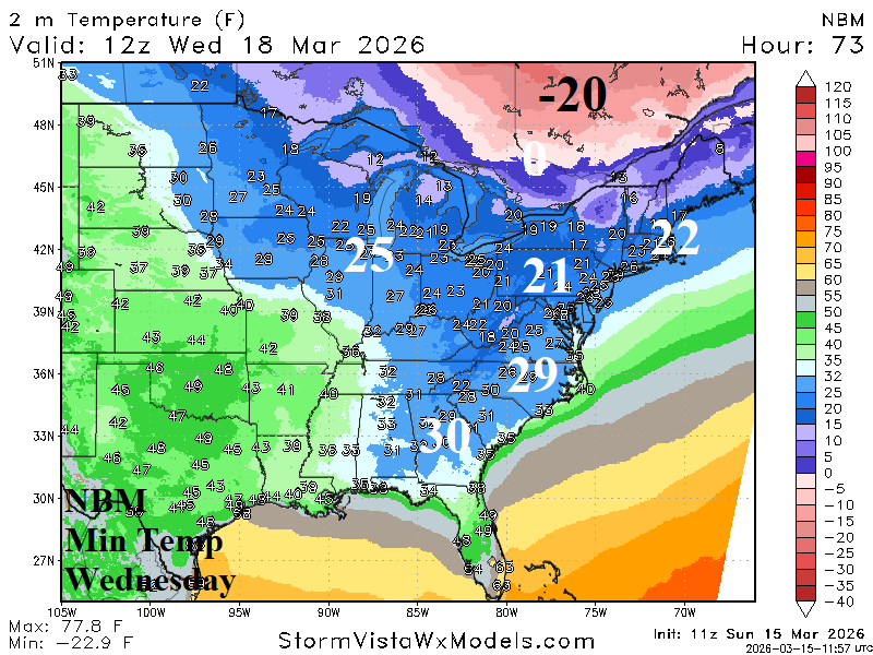
Fig. 4-6: NBM 48-hour snowfall forecast and morning minimum temperature projection for Tuesday and Wednesday morning.
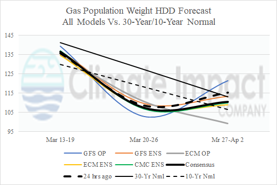
Fig. 7: U.S. gas population weight HDD forecast utilizing all models, their consensus, and comparison with 48 hours ago and 30-year/10-year climatology.