South America Alert: Central Brazil Drought Ahead; Wet Climate Backs Into Northeast Argentina
10/22/2023, 10:11 am EDTNorth Atlantic Tropics Week 2-4 Outlook: More late season trouble ahead!
10/25/2023, 5:22 am EDT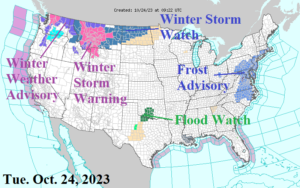
Fig. 1: NOAA/NWS weather watch, warning, and advisories.
Discussion: Here it comes…early winter weather is organizing over the Interior Northwest to the northwest Great Plains the next 1-2 days as Winter Storm Warnings are issued and will expand (Fig. 1). Meanwhile the onset of an extreme rainfall event in the Southern U.S. is showing signs with a Flood Watch posted for southern Oklahoma/northern Texas. Over-achieving morning chill in the East as Frost Advisories are issued for much of the Mid-Atlantic region.
The NOAA/WPC 7-day precipitation forecast identifies a stalled frontal system in the Central U.S. with unseasonably cold chill developing to the north while tropical moisture rides northward across the frontal boundary to enhance heavy rainfall (Fig. 2). The cold air will work its way southward reaching northwest Texas by the weekend when some wintery precipitation is possible. To the east of the storminess, the East observes some record warmth.
By Friday afternoon temperatures are in the low 90’s interior eastern Texas to the middle 80’s in central Illinois and approaching 80 in the Mid-Atlantic region while 10’s and 20’s hover across the northwest Great Plains (Fig. 3). On Sunday afternoon 30’s roll into Chicago and reach northwest Kansas while 80’s to low 90’s is spread across the Gulf and Southeast region (Fig. 4). The chilly change reaches the Northeast by Sunday. Early next week 30’s spread across western Texas with 30’s and 40’s across the Northern U.S. except 20’s over the snow-covered northern Plains (Fig. 5).
Next week is colder as the U.S. gas population weight HDD forecast flips from vigorous warmth this week to somewhat colder than normal next week (Fig. 6).
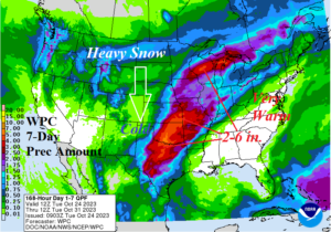
Fig. 2: The NOAA/WPC 7-day precipitation amount forecast across the U.S.
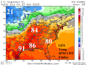
Fig. 3: GFS 2-meter temperature forecasts for 4PM CDT Friday afternoon.
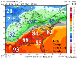
Fig. 4: GFS 2-meter temperature forecasts for 4PM CDT next Sunday afternoon.
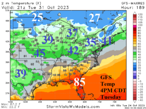
Fig. 5: GFS 2-meter temperature forecasts for 4PM CDT next Tuesday afternoon.
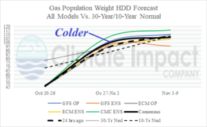
Fig. 6: U.S. population weight HDD forecast based on all models, their consensus, and comparing with 24 hours ago and the 30-year/10-year normal.