Shifting Madden Julian Oscillation, Wetter Brazil
09/19/2024, 10:21 am EDTThe Much Warmer Than Normal Eastern Gulf of Mexico
09/23/2024, 1:49 pm EDT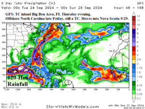
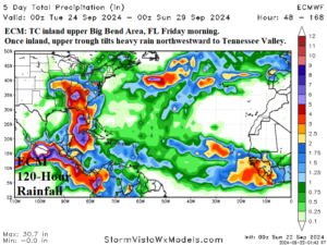
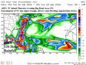
Fig. 1-3: GFS, ECM, and AIFS project a tropical cyclone into northwest Florida late this week with different trajectories to follow.
Discussion: A large mass of thunderstorms has gathered in the southwest and central Caribbean Sea. There is considerable mid-and-high-level wind shear across the Northwest Caribbean causing the convection to shift eastward during the past 24 hours. The eastward shift of the Madden Julian oscillation (MJO) across the tropical America latitudes is likely to enhance the convection and ease the upper shear over the next few days. Consequently, the immense upper ocean heat in the Caribbean Sea contributes to the evolution of a tropical cyclone. Tropical cyclones forming in this area during late September typically become hurricanes with implications for the eastern half of the Gulf of Mexico.
The GFS projects a tropical cyclone (likely a hurricane) through the eastern Gulf of Mexico midweek and inland the Florida Big Bend Area Thursday evening (Fig. 1). The ECM is a little slower (Friday morning) and slightly farther west (upper Big Bend Area of Florida) at landfall (Fig. 2). The machine learning (AIFS) projection is inland across the Florida Big Bend Area Thursday evening (Fig. 3). In summary ONE, forecast confidence is reasonable with a northwest Florida hurricane strike Thursday night/early Friday which features a major storm surge along the coast of the Florida Big Bend.
Once inland, forecast models disagree widely on where the attendant heavy rain migrates. GFS regenerates the tropical cyclone off the North Carolina Coast followed by a northeast to north trek into Nova Scotia. Extreme rains through the eastern Carolinas with this track followed by an extended period of high wind and flooding on the Northeast Corridor coast. ECM backs the tropical system northwestward as heavy rains shift across Alabama to the Tennessee Valley this weekend. AIFS indicates an excessive rain and flooding event into the length of the Appalachian States from Georgia to New York. In summary TWO, a major flooding event once the tropical cyclone is favored. Splitting the 3 possibilities at this long-lead favors the AIFS solution which calls for widespread flooding for the Appalachian States.