Are Marine Heatwaves Correlated to the Upper Air Pattern Causing Sensible Weather?
03/13/2026, 5:31 am EDT
Great Plains Trending Drier/Warmer; East Europe to Persian Gulf Trend Wetter (Next 15 Days)
03/22/2026, 9:02 am EDT
Climate Impact Company Season 1-4 Outlook
South America
Issued: Wednesday, March 18, 2026
Highlight: El Nino ahead in 2026; Wet short-term forecasts are expected to shift drier mid-to-late autumn, a mild winter, and a dry 2026-27 warm season for much of Brazil.
Executive Summary: An El Nino climate is projected to develop during the second half of 2026 and continue into early 2027 across South America. The Climate Impact Company constructed analog (CIC-CA) climate forecasts for the next 4 seasons are based on the evolution of an El Nino climate plus influences on climate from the tropical South Atlantic SSTA regime and tendency for strong marine heatwaves off each coast. Climate forecast highlights include a drier regime for mid-to-late autumn, a mild winter but with at least average risk of 1 or 2 threats of cold weather to Brazil coffee, followed by a drier than normal spring and summer in Brazil (away from the coast) causing regenerating drought. Dynamic models are wetter than the CIC-CA forecast in Brazil for the 2026-27 warm season forecast therefore forecast confidence is below average. Argentina is normally wet for the 2026-27 warm season.
Climate discussion: El Nino forecasts for 2026 are becoming increasingly confident (Fig. 1). The subsurface equatorial East Pacific has warmed aggressively (Fig. 2) although warming at the surface (Fig. 3) and response of the atmosphere is slow going (Fig. 4). The ENSO predictability barrier, present during FEB-APR each year, signals forecast confidence of El Nino ahead improves significantly in about 6 weeks. The anticipated El Nino will last through at least Q1/2027.
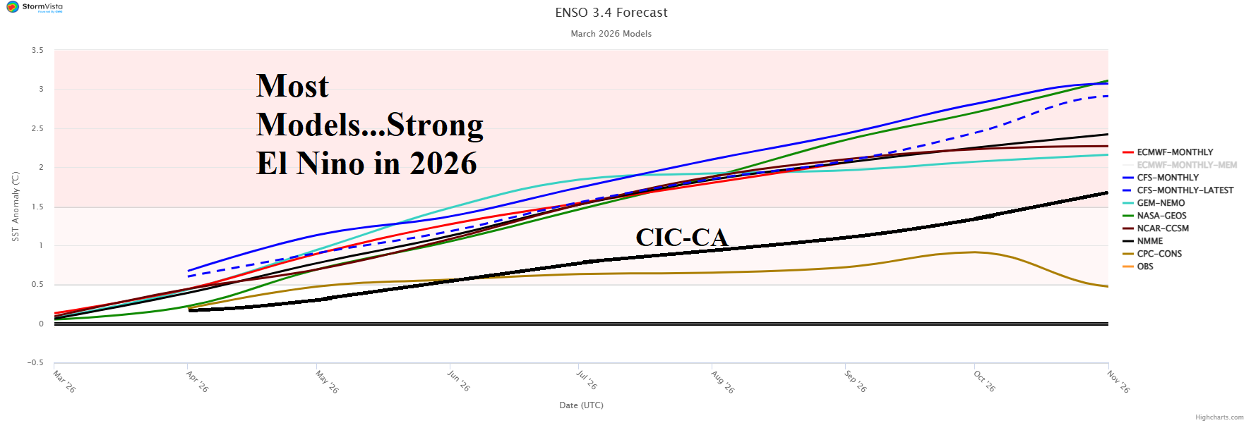
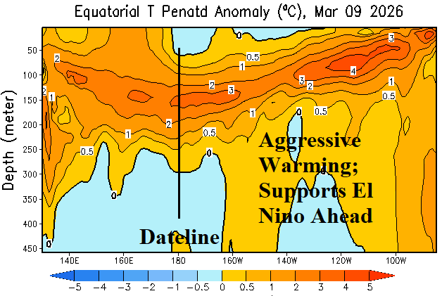
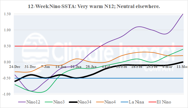
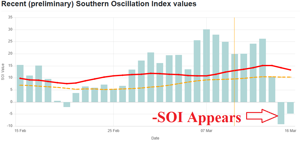
Fig. 1-4: Dynamic models Nino34 SSTA forecasts aggressively project a strong El Nino for later 2026 based primarily on strong upper ocean heat in the equatorial East Pacific although at the surface the Nino34 SSTA remains neutral and southern oscillation index has only recently shifted to negative phase.
Added factors include the tropical Southern Atlantic (TSA) index and marine heatwave (MHW) status either side of South America plus status of the Amundsen Sea cool pool.
If the TSA region shifts warmer than normal, a wetter El Nino climate emerges across South America well into the New Year. Currently, TSA is warming and has reached +0.53C. However, in accordance with climatology, most dynamic models keep TSA neutral during 2026. If the (current) warming TSA continues, climate forecasts will be wetter than indicated in this report.
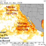
MHW’s either side of South America have become significant modifiers of the continental climate during the past 10-15 years. Currently, a large and long duration MHW occupies the waters off the West Coast of South America while a second MHW off the southern Argentina Coast is strengthening (Fig. 5-6). The IMME global SSTA forecast maintains each MHW slight shifting but little change in intensity through the middle third of 2026.
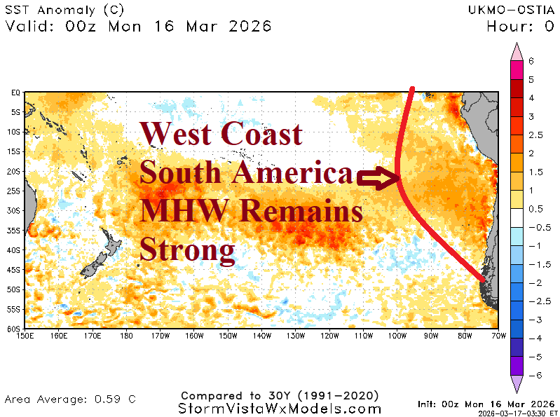
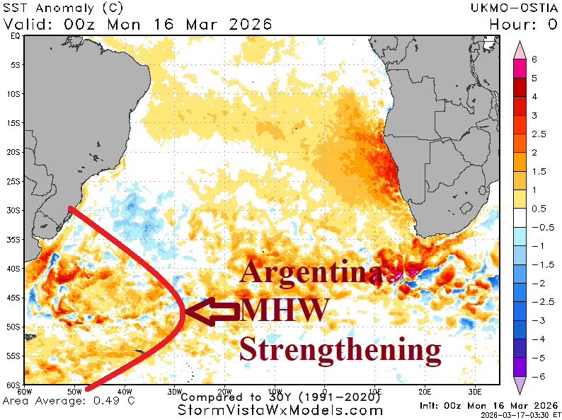
Fig. 5-6: Marine heat waves are prominently indicated off each coast of South America.
The Amundsen Sea cool pool is near neutral although IMME indicates some strengthening during the middle third of 2026. Implied is increased presence of an upper trough in this location which can affect the prevailing climate across South America during the winter season, usually increasing the risk of cold weather.
The ENSO, TSA, and MHW scenario(s) described follow the IMME projection for mid-to-late 2026 and guide the Climate Impact Company constructed analog (CIC-CA) forecast.
MAR/APR/MAY 2026: Based on the CIC-CA forecast, meteorological autumn 2026 is drier than normal across northwest and north Brazil plus Central Argentina to Uruguay while Northern Argentina is wet and much of Southern Brazil observes near normal rainfall. The forecast trend is less dry in Southern Brazil which is the correct trend given the observed wet start to March. The Argentina forecast trend is drier which is conflicting with the observed wetter March regime. Clearly, the CIC-CA forecast projects a drier mid-to-late autumn. The meteorological autumn 2026 forecast is warmer than normal across Argentina and Northern Brazil with southern continent receiving cooler than normal temperature.
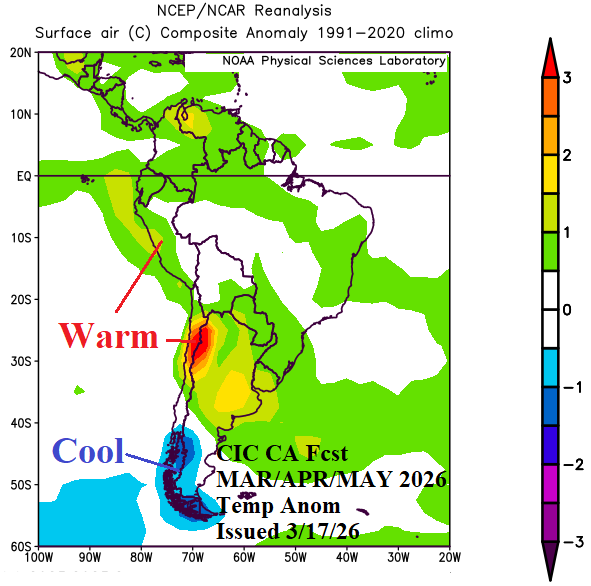
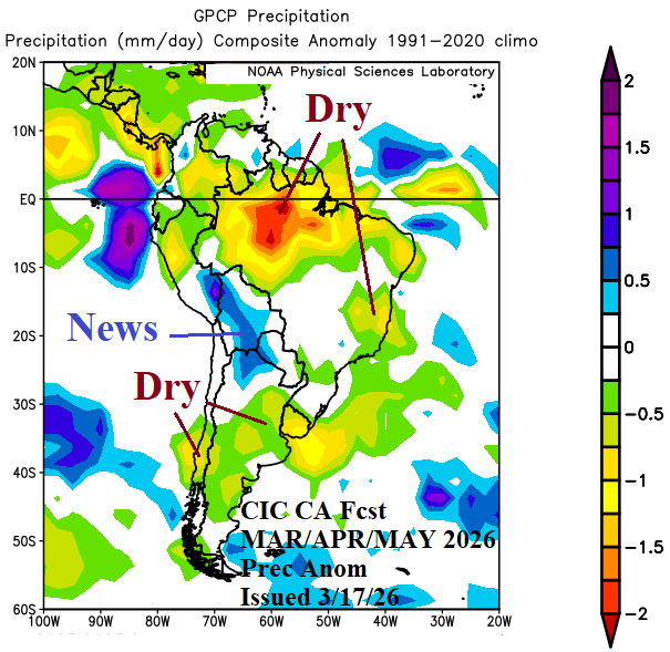
Fig. 7-8: The Climate Impact Company-constructed analog forecast of temperature and precipitation anomalies valid for MAR/APR/MAY 2026.
JUN/JUL/AUG 2026: Meteorological winter 2026 is warmer than normal although near normal in Southwest Brazil which identifies an opportunity for 1 or 2 brief cold periods mid-winter possibly affecting coffee growing areas. A cool pool of ocean water near and north of the Amundsen Sea located southwest of South America is forecast. Normally, a strong upper trough evolves across the cool pool and, at times, can omit shortwave energy into South America creating cold outbreaks. The risk of cold weather generated in this manor, is present for meteorological winter 2026. The precipitation is near normal except drier than normal across Northern Brazil.
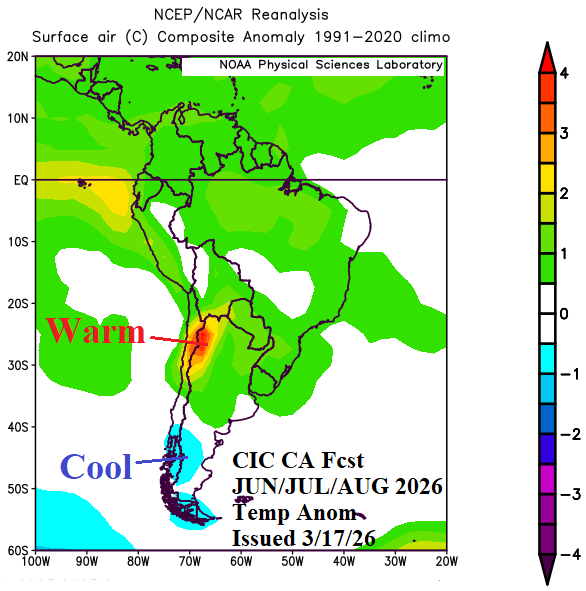
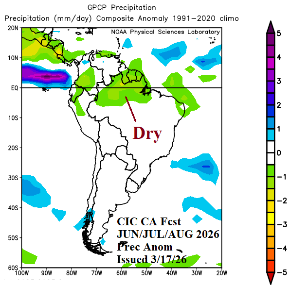
Fig. 9-10: The Climate Impact Company-constructed analog forecast of temperature and precipitation anomalies valid for JUN/JUL/AUG 2026.
SEP/OCT/NOV 2026: The meteorological spring forecast is made based on presence of a moderately strong El Nino presence (which could be stronger). The outlook is very similar to the CIC-CA forecast from 2 months ago. Heavy rain is projected across Uruguay and Southeast Brazil while areas to the north are somewhat warmer and drier than normal. Dynamic models are much wetter across Brazil than the CIC-CA forecast. One key is whether the TSA region is warmer than normal, if so, the wetter forecast is reliable. Despite the reasonably confident El Nino forecast, the South America rainfall outlook is made with below normal confidence.
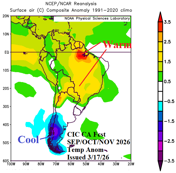
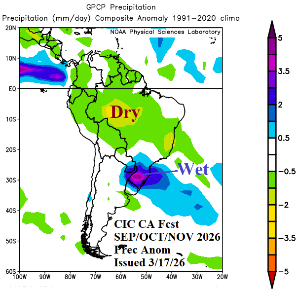
Fig. 11-12: The Climate Impact Company-constructed analog forecast of temperature and precipitation anomalies valid for SEP/OCT/NOV 2026.
DEC/JAN/FEB 2026-27: Meteorological summer 2026-27 occurs with mature phase El Nino present. The outlook is drier than normal across central and western portions of Brazil, consistent with the previous forecast. Wet climate is projected for Eastern Brazil. Wet climate is forecast for Northeast Argentina. Anomalous heat is dominant in Brazil. Much of Brazil encounters dry-to-drought conditions based on the warm season rainfall outlooks.
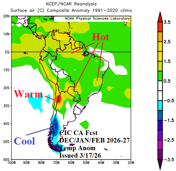
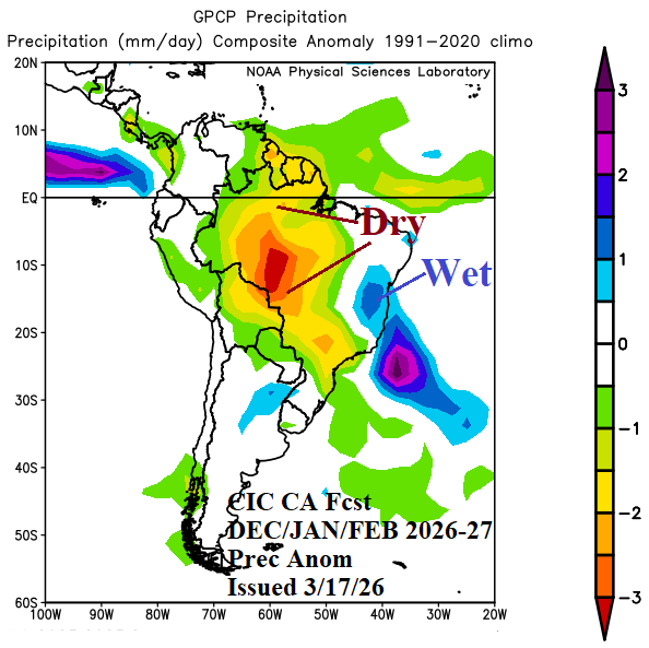
Fig. 13-14: The Climate Impact Company-constructed analog forecast of temperature and precipitation anomalies valid for DEC/JAN/FEB 2026-27.