News
05/29/2025, 3:54 am EDT
A map of the weather AI-generated content may be incorrect.

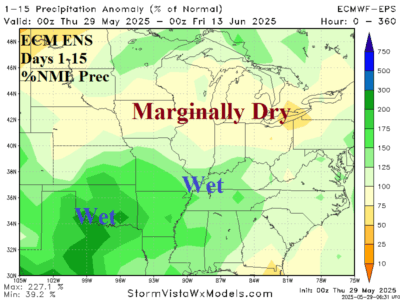
Mid-south U.S. Trends Wetter; Looks Wet for June

The Madden Julian oscillation 14-day forecast settles on phase_7/phase_8 during the medium range with increasing intensity justifying a cooler and wetter East U.S. forecast. The ECM ENS 15-day percent of normal rainfall outlook indicates wet weather, possibly heavy rain in the southern Great Plains with the wet regime expanding to the Tennessee Valley and southern Ohio Valley.
05/27/2025, 5:32 am EDT
A graph of a number of people AI-generated content may be incorrect.

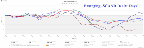
Negative Scandinavia Index Pattern Develops; Cools/Soaks North/Central Europe

Over the weekend, GFS indicated potential for an emerging chilly trough across Northwest Eurasia in the 11-15-day period. Last night, ECM joined forces with GFS as forecast confidence increases dramatically. The negative phase of the Scandinavia Index supports the presence of the projected Northwest Eurasia trough by the operational models.
05/23/2025, 9:12 am EDT
A map of the weather AI-generated content may be incorrect.

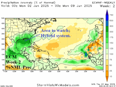
Watching The Gulf of Mexico for Early Season TC Risk

An upper trough located in the northwestern Gulf of Mexico spawning a massive amount of rain across the Gulf of Mexico affecting the coastal region. A careful watch late in the period for any subtropical/tropical low-pressure development.
05/21/2025, 9:37 am EDT
A map of the weather AI-generated content may be incorrect.

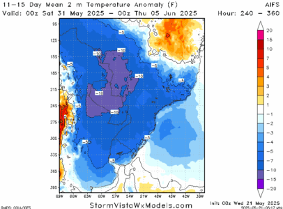
Season’s First Chilly Risk to Southern Brazil in 10+ Days

A chilly outbreak remains in the 11-15-day forecast across Argentina into Southwest Brazil as meteorological winter 2025 arrives. There is marginal <32F/<0C risk in northeast Argentina with the season's first cool burst. The intensity of this potential event may be a guide on additional cold risk as wintertime arrives in South America.