News
10/21/2024, 2:13 pm EDT

Neutral ENSO, No Sign of La Nina

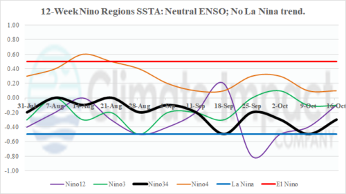
The Nino SSTA regions are locked-in on neutral phase. There is no shift in trend to indicate La Nina onset. In the subsurface, the anomalous cool water to fuel La Nina is diminishing. Most of the cool water is between 100 and 150 meters with about half the strength of several weeks ago.
10/21/2024, 8:28 am EDT

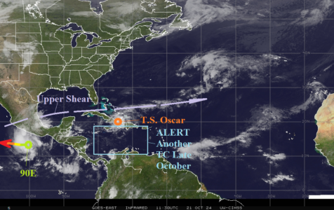
New TC Alert Posted for Central/East Caribbean Sea for Late October

An ALERT is posted for tropical cyclone development late in October for the central/east Caribbean Sea. A Halloween tropical cyclone is likely in this region. The next storm name is Patty. Early projections indicate a significant storm drifting north or northeast possibly affecting Hispaniola and/or Puerto Rico.
10/16/2024, 2:31 pm EDT

Marine Heat Waves Remain Dominant and Continue Climate Influence

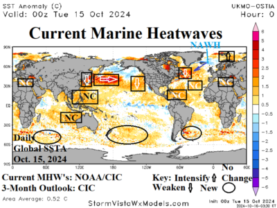
Marine heat waves continue to produce significant influence on where semi-permanent high-pressure areas form alongside their compensating low-pressure areas. Many MHW’s are ongoing in the northern hemisphere, the strongest east of Japan. Regenerating MHW’s are likely during the southern hemisphere summer in the subtropical/middle latitude oceans. The extensive warming of the ocean caused by MHW’s is likely suppressing La Nina onset.
10/15/2024, 7:52 pm EDT

Summer 2024-25 Focus on Evolving Drought Interior East Australia.

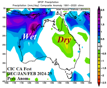
Meteorological summer brings suppressed heat risk across the western third of the continent while central and eastern Australia are hotter than normal. The precipitation regime is quite wet in the Northwest, near normal on the South Coast, and drier than normal from central New South Wales across much of Queensland. Summer drought risk during summer 2024-25 increases in Queensland to Northern New South Wales.