South America Season 1-4 Ahead Climate Forecast
03/18/2026, 5:54 am EDT
![]()
Climate Impact Company Sunday Global Weather/Climate Report
Issued: Sunday March 22, 2026
Highlights: U.S. AG Belt is less wet/warmer, Eastern Europe/Black Sea region shift wetter, and Northwest Argentina to Southeast Brazil sift drier/hotter.
ENSO: The Nino34 SSTA remains at zero and daily southern oscillation index (SOI) has recently shifted to weak negative phase. Upper ocean heat in the equatorial East Pacific remains impressive although slightly cooler during the past week. Dynamic models are each forecasting a robust El Nino episode mid-to-late 2026. The Climate Impact Company E Nino forecast is less robust. Thus far, the atmosphere and equatorial East Pacific Ocean surface are not reacting to the subsurface warmth. ENO remains in neutral phase. Climate forecasts should be biased toward weak La Nina to neutral ENSO as Q2/2026 arrives. Significant evidence that El Nino is forming in the eastern equatorial Pacific will need several to 6 weeks.
U.S. less wet pattern ahead: The U.S. AG Belt 6-10-day forecast is not as wet as most models indicated late last week. Anticipated wet weather holds off until the (more) unreliable 11-15-day period. In the 16-20-day period, models (including AI) are split on whether a wet weather-maker (upper trough over the Southwest U.S.) appears (or not). The 15-day temperature outlook shifts warmer. ECM is most aggressive with anomalous warmth in the 11-15-day period. The anomalous warm pattern could last into the 16-20-day period.
Europe/Black Sea: The precipitation pattern across Eastern Europe and the Black Sea region (also) has a different complexion. A wetter shift is indicated in the medium range. Additionally, much cooler weather develops for Central Europe toward the Black Sea region for late MAR/early APR. The wetter/cooler trend for Eastern Europe, the Black Sea region, and Southwest Russia continues in the 16-30-day period.
Persian Gulf/Iran war theater: Mid-week thundershowers appear across the Northern Persian Gulf and the Strait of Hormuz. A cold front bringing a squall line of showers and thundershowers arrive late this week. The problematic weather will impact military and ship-travel operations in this region this week. Trailing the cold front, next week shifts cooler. In the 11-15-day period, ECM delivers additional significant rain impacting operations.
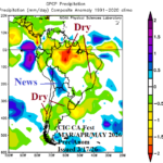
Brazil/Argentina: During the past week, heavy rain has affected parts of northern and eastern Argentina while patchy rains were observed across much of Brazil. During the past week, the dry zones are on the Uruguay/Argentina border and Northeast Brazil. Both GFS/ECM and AI Graph Cast emphasize dryness in the 15-day forecast for Northwest Argentina, Paraguay, and Southeast Brazil. After some cool weather this week, Northern Argentina to Southeast Brazil turn anomalous hot. Extended-range forecasts are mixed, agreeable to a showery regime in Argentina but split (wet or dry) across Brazil.
Australia: Tropical Storm Narelle is located over North-northwest Australia forecast to re-emerge off the Northwest Coast in a couple days and re-intensify to a category-3 tropical cyclone later this week with coastal impacts in the Onslow to Carnarvon stretch. Impacts to 3 LNG installations on the northwest coast of Australia are likely. The upper-level high-pressure ridge guiding Narelle westward is anchored over Western Australia this week causing widespread anomalous heat. However, the heat release of Narelle moving inland on the West Coast in the 6-10-day period shifts the upper ridge southward and to compensate a deep trough evolves over Eastern Australia bringing substantially cooler air but also a heavy rain threat to Southeast Australia.
The Important Charts
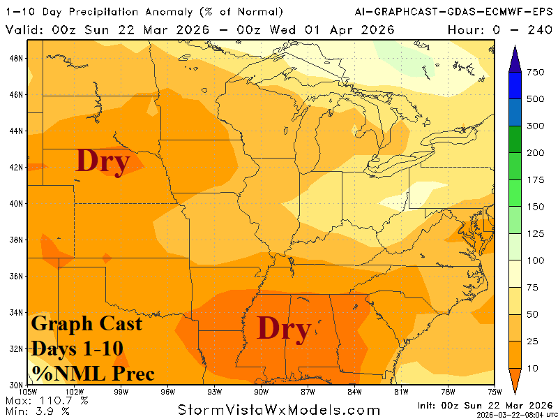
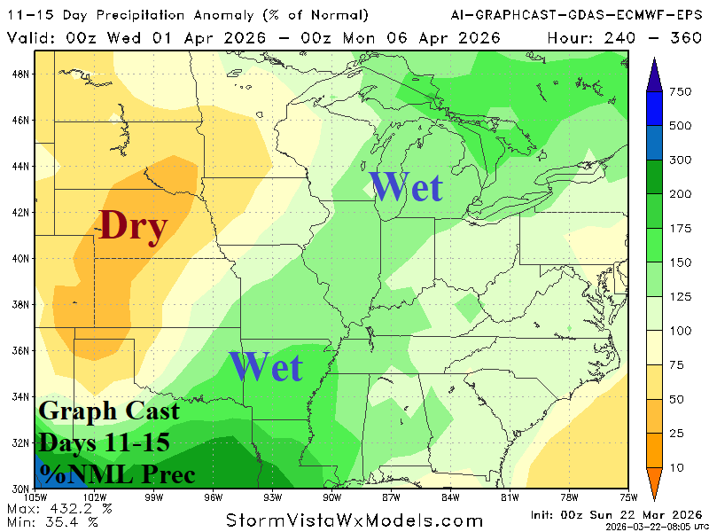
Fig. 1-2: The 10-day forecast across the U.S. AG Belt is drier/warmer while wet weather in the 11-15-day period may miss the Central Plains.
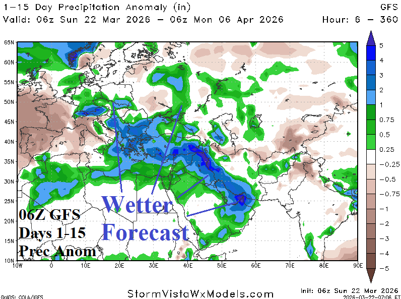
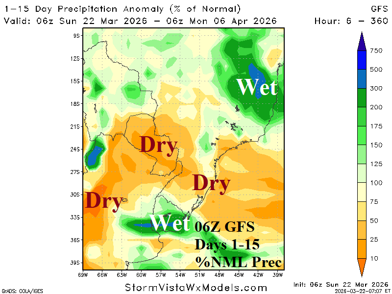
Fig. 3-4: A wetter trend in Eastern Europe, Black Sea region, and Persian Gulf in the latest 15-day outlook plus a drier/hotter Northwest Argentina to Southeast Brazil 15-day outlook.
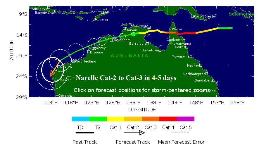
Fig. 5: The latest 5-day forecast for Tropical Storm Narelle.