U.S. January 2026 U.S. Climate Report: Warm and Dry 2025-26 Cold Season So Far with Cold East Exceptions
02/10/2026, 11:31 am EST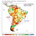
Patchy Rains Move across Brazil and Argentina; More Wet Weather Ahead for Brazil
02/16/2026, 11:58 am EST
Climate Impact Company AG Hot Spot
Issued: Thursday February 12, 2026
Highlight: Utilizing drier (CMC ENS) forecasts for South America mid-to-late February.
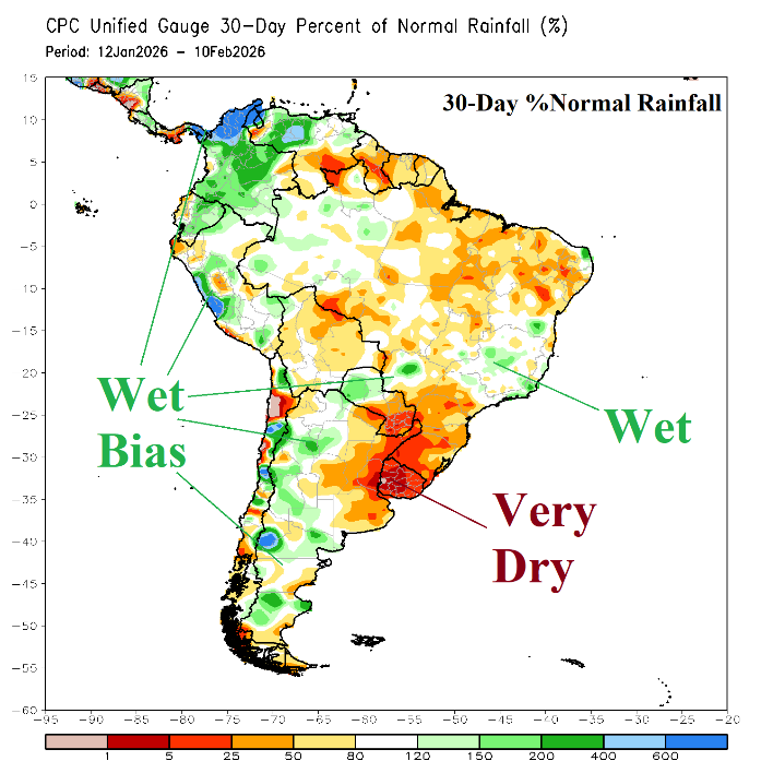
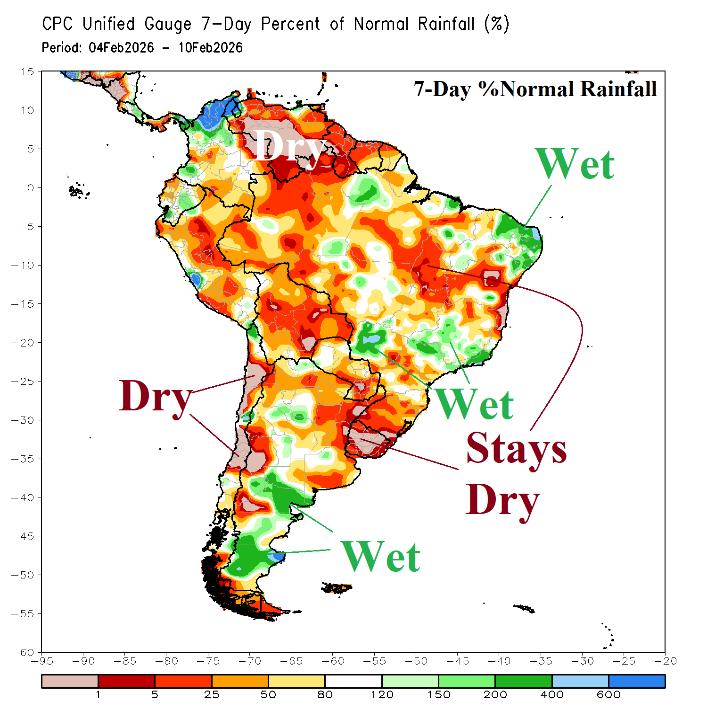
Fig. 1-2: The South America 30-day and 7-day percent of normal rainfall observations.
Discussion: The 30-day percent of normal rainfall observations identify a steady very dry signature centered on Uruguay and vicinity with a patchy wet bias across west and south portions of Argentina plus East Brazil (Fig. 1). The 7-day observations are drier except wetter Central Argentina, Northeast Brazil, and parts of Brazil due east of Paraguay (Fig. 2). The 15-day rainfall forecast bias utilizing all models remains too wet for the northern 60% of Brazil. Consequently, drier forecasts are preferred in today’s 3-week outlook. Additionally, a dry bias provided by phase_3/phase_4 of the Madden Julian oscillation (MJO) is recognized.
The CMC ENS 500 MB forecasts have ranked first during the past 2 weeks across South America. The weather pattern forecast for the next 7 days yields rainfall across North/Northeast Argentina plus Northeast Brazil and dry elsewhere (Fig. 3). In the 8-14-day period, rainfall is heavy and consolidates in East Brazil (Fig. 4). The CMC ENS projects a weak upper ridge off the Southeast Brazil Coast during the 16-30-day period. A rainfall forecast for that time frame by CMC ENS is not available. However, AI Graph Cast is reasonably close with the upper air projection and forecasts some wet weather across the southern half of Argentina, Southeast Brazil, and most of northwest continent (Fig. 5).
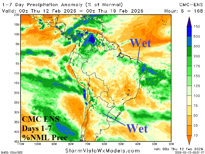
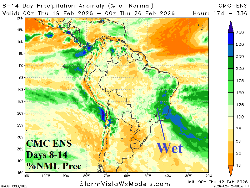
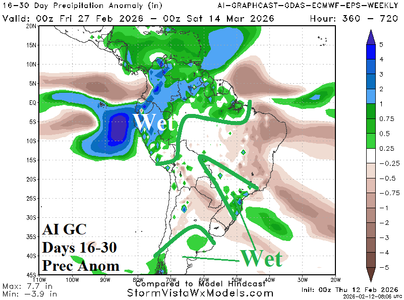
Fig. 3-5: The CMC ENS 14-day percent of normal rainfall forecasts across South America and the AI GC 16-30-day rainfall anomaly outlook for South America.