Does a Dry/Hot Bias Develop in Eastern Australia Due to IOD/ENSO?
10/29/2024, 5:42 am EDTThe Valencia, Spain Floods
11/01/2024, 8:25 am EDT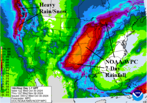
Fig. 1: The NOAA/WPC 7-day quantitative precipitation forecast.
Discussion: An unusually extended period of dry climate across much of the U.S. (except for where tropical cyclones went inland) will end with change of the month. Thanks to a transient convection phase of the Madden Julian oscillation (MJO) across the equatorial Pacific Ocean, the Pacific polar jet stream carries storms into the Northwest U.S. and Southwest Canada in the latest NOAA/WPC 7-day quantitative precipitation forecast (QPF). The subtropical jet is energized by the transient MJO and scoops low latitude moisture into the Central U.S. piling to 7+ in. in Southeast Kansas over the next 7 days (Fig. 1). The rain should help raise the Mississippi River where low water has returned for a 3rd consecutive year.
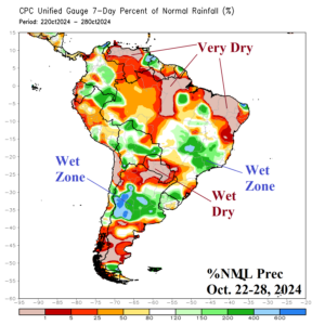
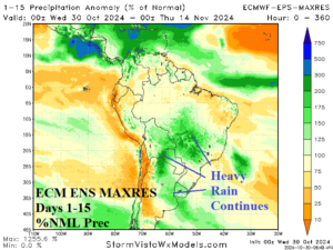
Fig. 2-3: The 7-day percent of normal rainfall observations and 15-day percent of normal rainfall forecast across South America.
The 7-day percent of normal rainfall observations across South America reveal the ongoing wet pattern in East Brazil and Central Argentina while equally impressive dry zones also appear in Paraguay and northern continent (Fig. 2). The 15-day outlook utilizes ECM ENS which indicates a slight dry bias over East Paraguay/Southeast Brazil surrounded by potential for prohibitive rainfall (Fig. 3). A transient Madden Julian oscillation across the equatorial Pacific helps to sustain the wet forecast.
A cold upper trough shifts across Northeast Eurasia next week causing the season’s first snowfall which expands snow cover from Siberia westward and across most of Russia by 10 days from now (Fig. 4). In Australia, amplified high pressure has caused a widespread searing heatwave that shifts farther east in the 6-10-day period as temperatures exceed 100F/38C for much of the continent (Fig. 5).
Another devastating tropical cyclone strike to Taiwan is forecast for late week due to the approaching Category-4 Major Typhoon Kong-Rey (Fig. 6). The Northwest Pacific has produced 6 major typhoons in 2024 so far, 8 is normal. So far in 2024, only the North Atlantic basin has observed greater than normal hurricanes/major hurricanes.
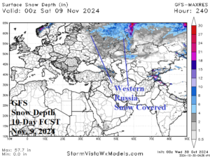
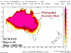
Fig. 4-5: The 240-hour GFS snow cover forecast for Russia and 6-10-day ECM ENS >100F risk zone.
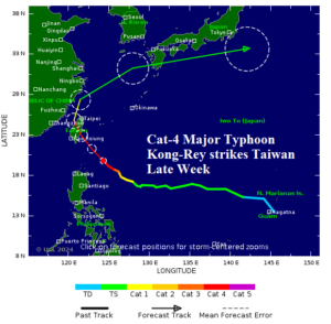
Fig. 6: Category-4 Major Typhoon Kong-Rey is forecast to strike Taiwan late week.
