Milton Reaches Category-5 Major Hurricane Status at 11:05 EDT
10/07/2024, 12:17 pm EDTCategory-4 Major Hurricane Milton Begins Northeast Turn Toward Florida
10/08/2024, 5:57 am EDTCharts of the day: Optimum climate normal and Europe winter climate.
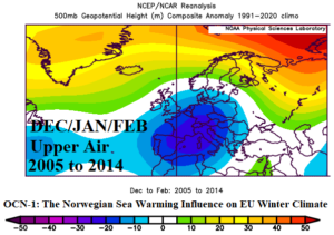
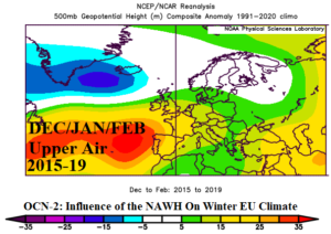
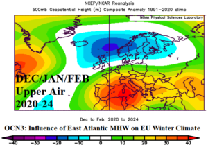
Discussion: Due to accelerating influences of climate change on “normal weather” Climate Impact Company uses optimum climate normal (OCN) as a starting point for seasonal forecasts. An OCN is a shorter period of consistent climate compared to the standard 30-year climatology identifying a different pattern compared to the long-term average. A top climate predictor of Europe winter climate during 2005-14 was the tendency for anomalous warm oceans northwest of Europe to warm the atmosphere aloft and support the presence of high pressure blocking over Greenland often referred to as negative North Atlantic oscillation (-NAO). During that 10-year period, an upper-level trough over Southwest Europe favored colder than normal winter. During 2015-19 emergence of the North Atlantic warm hole (NAWH), a cool SSTA pattern south and east of Greenland, was well-correlated with an upper trough across that region (including Greenland). The -NAO pattern reversed and on average Europe wintertime flipped warmer than normal. During recent years, the tendency for a marine heat wave (MHW) off Southwest Europe and in the Mediterranean Sea has amplified an upper ridge over Southern Europe responsible for maintaining warm winter climate and compensated for by a Northwest Europe trough likely associated with the lingering NAWH regime. The 2020-24 OCN-3 upper air pattern has, on average, caused increasing wintertime precipitation from London to Moscow.
Week-2 Ahead Forecast valid October 13-19, 2024: Wet weather consolidates in the Black Sea region.
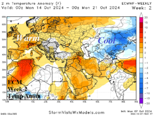
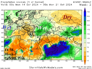
Discussion: Upper ridge patterns are well-amplified and centered on Northern Italy and West-central Russia. In-between is an upper trough brining wet weather to the drought region across Southwest Russia and much of the Black Sea region.
Week-3 Ahead Forecast valid October 20-26, 2024: Lingering lighter rain Black Sea region and eastward.
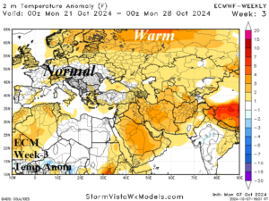
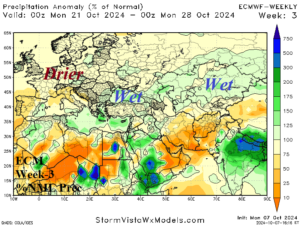
Discussion: The upper trough in the Black Sea region shifts slightly eastward and is weaker. However, still able to produce a showery regime in the immediate Black Sea region to Kazakhstan. Europe cools to near normal, while Northwest Eurasia is warm.
Week-4 Ahead Forecast valid October 27-November 2, 2024: Staying wet Black Sea region eastward.
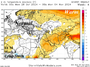
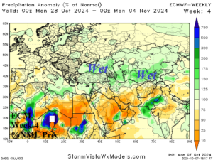
Discussion: ECM maintains a weakness in the upper air pattern in the form of an upper trough centered on Southwest Russia into early November. Consequently, the Black Sea region eastward to Kazakhstan stays wetter than normal.