Conflicting ENSO Signals in February but Flip to La Nina Remains in Forecast for 2nd Half of 2024
02/11/2024, 5:33 pm ESTLate Summer 2024 Drought For The Southeast U.S. Including Florida and Texas
02/15/2024, 7:43 pm EST


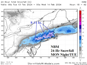
Fig. 1-3: NOAA flooding rainfall and severe weather risk areas for today plus the NBM 24-hour snowfall forecast for tomorrow.
Discussion: Storm system in the Southeast U.S. is centered on Northern Alabama at midday. Severe thunderstorms including tornadoes are spawned across the Florida Panhandle to Georgia (Fig. 1) while heavy rain brings flooding to Alabama/Georgia today and into the Carolinas tonight (Fig. 2). By tonight, the storm moves into Virginia with heavy rain and high wind including coastal flooding throughout the Mid-Atlantic region while snow and sleet emerge in the eastern Ohio Valley to New York State. On Tuesday, a full-throttle snowstorm emerges in the Northeast U.S. most-focused on New England to northeastern Pennsylvania where snowfall amount in the 8-14 in. range is expected (Fig. 3). The storm becomes a “bomb cyclone” moving past Nantucket tomorrow afternoon. High wind brings power outage risk and coastal flooding to east/southeast New England.
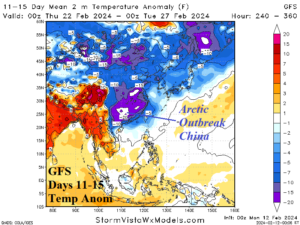
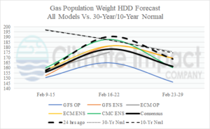
Stratospheric warming leading to evolution of a large arctic air mass remains in the forecast for Eurasia. Latest indications are the air mass releases southeastward into China in the 1-15-day period (Fig. 4) rather than cross-polar into North America. Consequently, the U.S. gas population weight HDD forecast is revised milder for the second half of February (Fig. 5).

Fig. 4: The GFS 11-15-day temperature anomaly forecast for Asia identifying release of arctic air into China.

Fig. 5: The U.S. gas population weight HDD forecast utilizing all models, their consensus, and comparing with 24 hours ago and the 10-year/30-year normal.
