Tracking Mid-February Arctic Air
02/11/2024, 10:02 am ESTArctic Air Evolving in Eurasia to Release into China in 11-15 Day Period
02/12/2024, 5:26 am ESTExecutive summary: Conflicting signals in February regarding ENSO as sharp negative phase southern oscillation index (-SOI) reveals the El Nino climate for the 2023-24 episode is peaking while the subsurface equatorial Pacific Ocean is cooling rapidly as ocean warming to sustain El Nino is fading fast. The outlook maintains a rapid decline in El Nino intensity during the next 2-4 months with neutral ENSO likely by MAY/JUN followed by further Pacific cooling causing La Nina to form by JUL/AUG. La Nina may last into 2026.
Discussion: During January 2024, anomalous convection in the Pacific tropics fueled by warmer than normal El Nino waters persisted near and east of the Dateline, typical of mature stage El Nino (Fig. 1). To compensate, sinking motion, or subsidence, caused dry climate over East Africa and Brazil/Argentina. Although forecasts are in general agreement that El Nino will weaken over the next 2 months, the atmosphere is showing its strongest El Nino climate signature so far as the February projected southern oscillation index (SOI) is nearly -3.0 (Fig. 2). The daily SOI has dropped to -4.1 in recent days in response to a strong convection phase of the Madden Julian oscillation (MJO) shifting near and east of the Dateline. This event has spawned the “atmospheric river” storm track across the North Pacific slamming California with “bomb cyclones”. While atmospheric El Nino is strengthening, the upper ocean heat fueling El Nino is diminishing rapidly (Fig. 3). A widespread cooler than normal ocean layer is expanding eastward across the entire tropical Pacific implying the leftover warm waters just beneath the equatorial Pacific is fading fast. Probabilistic forecasts indicate El Nino should weaken quickly during northern hemisphere spring to neutral phase before midyear arrives and shift into La Nina for the second half of 2024 (Fig. 4). The Climate Impact Company constructed analog is agreeable with the probabilistic forecast and indicates La Nina should last through DEC/JAN/FEB 2025-26 (Fig. 5).
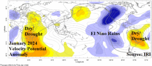
Fig. 1: Potential vertical velocity anomalies identifying zones of convective clouds in the tropics as governed by ENSO for January 2024.
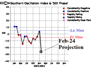
Fig. 2: The southern oscillation index is projected to surge to a strong negative phase in February 2024, the strongest El Nino signature for the 2023-24 event.

Fig. 3: The February 2024 (so far) equatorial subsurface Pacific Ocean upper ocean heat analysis reveals sudden and rapid cooling.
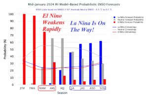
Fig. 4: The International Research Institute ENSO probability forecast valid through 2024.

Fig. 5: The Climate Impact Company constructed analog forecast of ENSO phase through DEC/JAN/FEB 2025-26.