Brazil and Middle East Drought to Worsen, Southeast Asia/Indonesia Reverse Wetter Ahead
02/07/2024, 5:04 am ESTConflicting ENSO Signals in February but Flip to La Nina Remains in Forecast for 2nd Half of 2024
02/11/2024, 5:33 pm EST
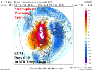

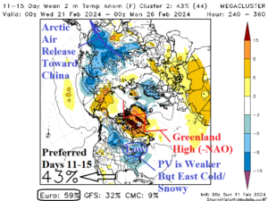
Fig. 1-4: Mega-cluster ensemble projections of northern hemisphere temperature anomaly patterns through the next 15 days and the ECM 6-10-day stratospheric warming event.
Stratospheric warming and arctic air discussion: Departure from the core of boreal winter, a plethora of major modes of climate variability are generating. Most prominent is the recent emergence of the strongest convection phase of the Madden Julian oscillation (MJO) of the 2023-24 El Nino. The surge of MJO convection past the Dateline in the tropical Pacific helped to motivate a Pacific “atmospheric river” storm track bringing “bomb cyclones” to California. Speculated is the latent heat release from this MJO episode may have traveled upward and poleward in the atmosphere to trigger a 3rd stratospheric warming event in the polar region. Of course, the consequence of stratospheric warming is generation of arctic air at ground level. This week arctic air is born over the western half of Russia where temperatures plummet to -40F (Fig. 1). Arctic air masses like to generate in this region due to the lack of exposure of moderating marine influences. The stratospheric warming episode peaks during the 6-10-day period biased toward Siberia to northwest North America side of the North Pole (Fig. 2). Forecast models project a “ridge bridge” over Alaska during the 6-10-day period. Consequently, a narrow channel of cross-polar airflow develops and invites a piece of the expanding arctic air mass across Eurasia to surge through Canada to intensify a polar vortex (PV) near James Bay downstream from the Alaska ridge (Fig. 3). The PV evolution is supported by a vigorous negative East Pacific oscillation (-EPO) forecast. Arctic air is deposited into the U.S. Northern Continental Divide and much of the snow-covered Northern U.S. should turn chilly. The southern extent of the chill is reliant on snow cover which is well below normal right now (Midwest to Mid-Atlantic U.S.). In the 11-15-day period, the polar vortex is losing arctic character but is maintained shifting eastward (Fig. 4) by an evolving Greenland blocking high pressure (negative North Atlantic oscillation). In the 11-15-day period, the East U.S. is cold and snowy away from the coast. Note that the arctic air mass loses intensity released primarily toward China in the 11-15-day period despite a piece of this air mass briefly traveling cross-polar into North America. The December arctic air outbreak released from Eurasia to China, the January episode traveled cross-polar to North America, and the 3rd event is a combination of the two trajectories (therefore not as strong).