Arctic Air Evolving in Eurasia to Release into China in 11-15 Day Period
02/12/2024, 5:26 am ESTNew Arctic Air Mass Developing Alaska/Western Canada
02/20/2024, 4:03 am ESTExecutive summary: The Climate Impact Company constructed analog 6-month precipitation forecast for the U.S. coupled with current soil moisture and trend yields the second half of summer U.S. drought risk areas. Most prominent and agreeable to the NOAA CAS forecast is Georgia and Florida followed by Texas. The CIC-CA projection adds the Northwest U.S. and northern Great Lakes. The Midwest U.S. is likely to avoid a 2024 drought.
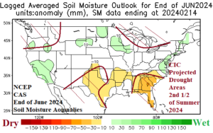
Fig. 1: Climate Impact Company projected drought areas for the second half of summer compared to the end of June NOAA/CAS soil moisture anomaly outlook.
Discussion: U.S. soil moisture anomalies are drier than normal across the Midwest U.S. including the Ohio Valley and adding the Rio Grande Valley region (Fig. 2). Wet soil conditions have evolved in California and the Northeast Corridor. The seasonal soil moisture change, typical of an El Nino winter, is a dramatic wet signature across California especially near the coast plus the northwest Gulf States and northeastward into the Atlantic States (Fig. 3). More recently, the wet signature in California has strengthened in February while the northeast quadrant of the U.S. has turned drier (Fig. 4). The warm winter has prevented a gathering snow cover (Fig. 5) to the east of the Continental Divide except for New England (recently). The Interior Northwest has mostly bare ground. Atmospheric El Nino has lagged oceanic El Nino intensity although recently catching up as Pacific storms wring-out precipitable water in the West U.S. and parts of the Southeast U.S. while the attendant warmth causes the U.S. to lose snow cover.


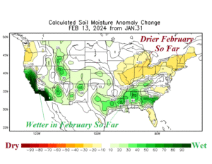
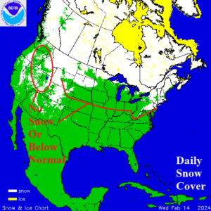
Fig. 2-5: Daily U.S. soil moisture anomalies, the seasonal and February (so far) change, and North America snow cover.
As meteorological winter winds down, drought is officially ongoing in New Mexico and vicinity, Iowa plus nearby locales, and northwestern Mississippi. The Canadian Prairies remain mostly dry. The 2023-24 El Nino climate is peaking now, while oceanic El Nino is past peak. The equatorial subsurface Pacific Ocean is cooling steadily (Fig. 6) signaling an end to El Nino during Q2/2024 (Fig. 7). ENSO is likely to shift into La Nina during the second half of 2024.
Meanwhile, typical of late winter, the dominant warmer than normal North Pacific and North Atlantic surface temperatures of the past decade have cooled. However, vigorous warming of each basin fueled by restrengthening marine heatwaves (MHW) occurs mid-year (Fig. 8). The warmer-than-normal mid-latitude oceans have contributed to prevailing climate patterns across North America during the past decade (Fig. 9).
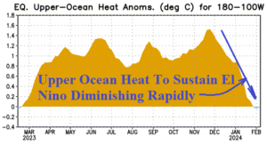

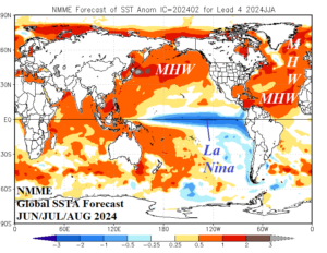
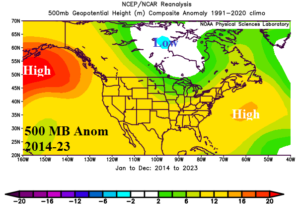
Fig. 6-9: The equatorial upper ocean heat anomalies east of the Dateline, collection of dynamic models ENSO forecast for June 2024, NMME global SSTA forecast for JUN/JUL/AUG 2024 and prevailing upper air pattern for 2014-23.
The precipitation climate outlook for the next 6 months to determine where drought develops in the U.S. during late summer is based on a constructed analog (CA) that indicates a transition from El Nino to La Nina and accounts for the warming of the mid-latitude oceans and influence on climate of the past 10 years.
The precipitation projections for both MAR/APR/MAY and JUN/JUL/AUG 2024 yield significant amount of rain (Fig. 10-11). The CA forecast implies a wet climate during meteorological spring due to the latent heat release of warm El Nino waters in-place now poleward into the prevailing jet stream pattern to generate the above normal rainfall result.
The summertime wet signature across the Midwest U.S. is mostly related to the mid-latitude ocean anomalies rather than ENSO. In-between upper-level high-pressure ridge areas located across the vast warmer than normal ocean waters of the northeast Pacific and western North Atlantic, a compensating upper trough rests over the Midwest States to cause a wet climate. The northwest Gulf of Mexico heavy rainfall pattern is related to tropical cyclones.
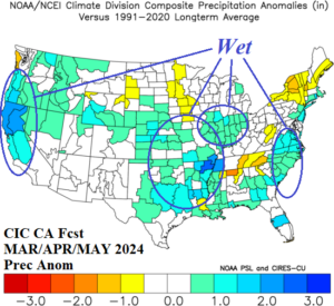

Fig. 10-11: Based on a constructed analog considering ENSO phase change from El Nino toward and into La Nina from the climate change era (past 30 years) and the tendency of robust warming of the mid-latitude oceans of the past 10 years (minus strong ENSO signatures during mid-year) a projection of the most likely U.S. precipitation anomalies for MAR/APR/MAY and JUN/JUL/AUG are indicated.
The second half of summer drought risk areas, based on the CIC-CA forecast, are located across the Northwest U.S., southwest Great Plains and western Texas, the Southeast States plus Florica, and the northern Great Lakes region (Fig. 12). The CIC-CA forecast annotates onto the NCEP-CAS soil moisture anomaly forecast for the end of June. There is general agreement between the two forecasts on drought risk in Texas and the Southeast U.S. The CIC-CA JUN/JUL/AUG 2024 forecast is dry and given expected hotter than normal temperatures, drought could emerge during late summer on the East Coast.
Fig. 12: Climate Impact Company projected drought areas for the second half of summer compared to the end of June NOAA/CAS soil moisture anomaly outlook.